
Laboratory Borehole Inclinometer Measurement Experiment - For More Accurate Understanding of Landslide Movement
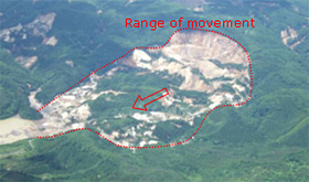 Landslide, at Aratozawa, Kurikoma, Kurihara city, Iwate prefecture, that occurred following the Iwate-Miyagi Nairiku Earthquake in 2008 (photo taken on June 15). |
 Slip surface measurement |
 Experiment to reproduce incomprehensible measurement results |
A landslide is a phenomenon where the side of a mountain slides downward as a large soil mass. Although this movement is too slow to see, a wide area can suddenly move many meters as the result of heavy rain, melting snow or an earthquake, as shown in the photograph on the right, causing devastating damage to houses, farmland, roads and railroad as it accelerates downward. The photograph on the right shows a landslide caused by an earthquake.
One way to prevent landslide damage is to stop the movement of the soil mass on the slope. To develop appropriate measures for this, we must know the depth of the soil mass as it moves in a landslide. The movement is not sudden as with that caused by an earthquake or heavy rain, but so slow that it cannot be observed with the naked eye. It is also important to have measures in place before the occurrence of a large landslide.
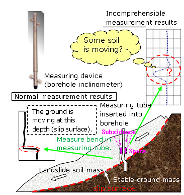
To understand landslide movement, a hole about 9 cm in diameter is drilled vertically into the landslide soil mass with a boring machine, and a measurement tube about 5 cm in diameter is inserted into the drilled borehole. Then a measuring device called a borehole inclinometer is inserted into the tube to measure any bending that occurs in the tube. The position of the bend then tells us the depth of the soil mass that is moving (slip surface). But some of these measurements reveal kinds of movement that do not appear to be related to a landslide. Incorrect measurement results can lead to misjudgment of the sliding depth and result in the adoption of inappropriate landslide countermeasures.
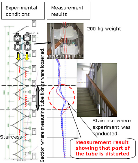
The Landslide Research Team is currently conducting joint research with three private corporations to clarify the causes of such incomprehensible measurement results. One of the joint projects is an ongoing experiment to understand changes related to the measurement tube, such as changes in the level of force imposed on the tube or the effect of rough handling of the tube on the measurement results. This experiment uses a measurement tube approximately 30 m long that is fixed vertically in the void space of our building´s staircase from the first basement floor to the 8th floor.
In July, part of the measurement tube was loosened from its fixings, and a maximum weight of about 200 kg was applied to the top of the tube to reproduce the ground subsidence conditions that would induce the gap to appear between the tube and a landslide soil mass. The measurement result we obtained showed that the tube seemed to be distorted vertically in the section where the fixings were loosened. This suggests that unless the measurement tube is firmly fixed to the ground, incomprehensible measurement results may occur as a result of the distortion of the tube unconnected with the movement of the landslide.
In the future, we intend to develop an appropriate measurement tube installation method that will not result in a gap between the tube and the ground, and then conduct experiments to clarify other factors that appear to generate incomprehensible measurement results.
(Contact: Landslide Research Team)
Provision of borehole data via the Internet - For Sharing Borehole data
 Search and review of borehole data using electronic national land web system |
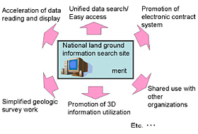 Advantages of ground information search website 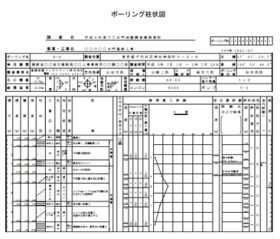 Borehole columnar section showing thelithology and strength of the subsurface, groundwater level and other information. |
Before construction work is undertaken, a drilling survey is generally conducted to collect data on, for example, the lithology and strength of the subsurface, and the location of groundwater. Such borehole data obtained from construction work is also useful when developing measures against ground settlement or ground contamination or predicting the motion of earthquakes. The Geology Team conducted research on the sharing of borehole data.
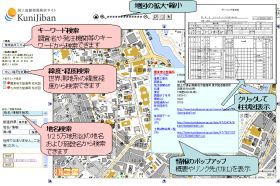
PWRI maintains a website dedicated to national land borehole data, KuniJiban, (http://www.kunijiban.pwri.go.jp) jointly with the Ministry of Land, Infrastructure, Transport and Tourism (MLIT) and the Port and Airport Research Institute, and provides free borehole data including boring logs and lists of rock property test results. Such borehole data is obtained from geologic and soil surveys related to road and river projects conducted by MLIT. PWRI has developed a system for displaying boring positions on electronic maps using an Cyberjapan web system that makes it easy to search for and access borehole data. These efforts promote the easy and efficient exchange of borehole data between the national government and local governments. In addition, this work is expected to further improve the efficiency of social capital development by preventing unnecessary ground surveys and facilitate environmental preservation and disaster prevention efforts.
Since March 28, 2008, the system has been in the trial demonstration stage, providing boring logs for some 27,000 boreholes and lists of geologic test results in the jurisdictions of the Kanto Regional Development Bureau and Kyushu Regional Development Bureau. Borehole data in the jurisdictions of other regional development bureaus will be disclosed sequentially after FY 2008.
This research is conducted as part of the National Land Traffic Geographic Space Information Platform under the Outline of Innovation Promotion in the National Land Traffic Field (May 2007), which started in response to the proposal "Toward Advanced Utilization of Borehole data" of the Review Committee on Accumulation and Utilization of Borehole data, MLIT, headed by chairman Kazuo Konagai, Prof. of Tokyo University, in March 2007, and the MLIT CALS/EC Action Program 2005. For our research we also use some of the results available in the "Establishment of Integrated Geophysical and Geological Information Database," an "Important Problem-solving Research" program under the science and technology promotion and adjustment budget of the Ministry of Education, Culture, Sports, Science and Technology.
(Contact: Geology Team)