
Micro-organisms strengthen soil!?
- Using micro-organisms to improve soil -
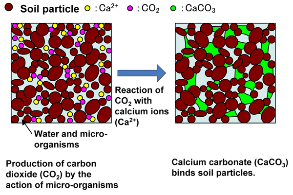 Figure 1. Soil Improvement by Micro-organisms |
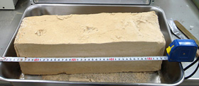 Photo 1. Improved Soil Using Micro-organisms |
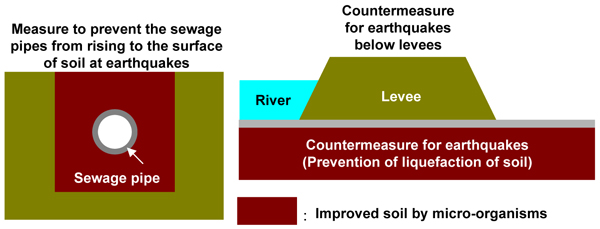 Figure 2. Application of Soil Improvement |
Soil Improvement
Soil supports the roads and bridges we daily pass, the buildings we inhabit, and sewage pipes buried underground.
But in its natural state, soil often cannot sufficiently fill such roles,
and in these cases, we improve the soil. For example, there may be cases
in which soil lacks sufficient strength to support a building, or may be
changed into liquid state by earthquakes.
Development of technology using micro-organisms to improve soil
Using the action of micro-organisms is expected as a promising method of
improving soil. Calcium carbonate (CaCO3) is produced by the reaction of carbon dioxide (CO2) micro-organisms in the soil emit with calcium (Ca2+) in the void between soil particles. Calcium carbonate is a hard substance
which is made by natural reaction such as speleothems. Calcium carbonate
strengthens soil by acting as an adhesive which binds soil particles (Fig.
1).
It is important to stimulate the action of micro-organisms and to produce
large quantities of calcium carbonate. So nutrients are added to ground.
In short, invigorating foods are given to the micro-organisms.
Differences in the degree of strength of soil (quantity of calcium carbonate created) appear according to the environment the micro-organisms inhabit (types and quantity of micro-organisms, soil types, etc.), and the way they are given food (nutrient injection conditions etc.). So testing is carried out to learn those conditions which promote strengthening of the soil (Photo 1).
Future expectations as a soil improvement technology
Soil improvement methods like this are expected as a technology that is
applicable to the soil under roads or buildings. They are also expected
to be widely applied, for example, as material to bury sewage pipes, to
prevent the pipes from rising to the surface of soil and the soil around
the pipes being liquefied by earthquakes (Fig. 2).
(Contact: Soil Mechanics and Dynamics Research Team)
To Support Safe Driving during Snowstorms
- A study on poor visibility during snowstorms -
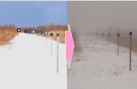 Visibility target plates - Nine plates were placed at distances of 10 to 255 m. |
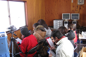 Visibility assessment by test subjects - The number of visible target plates and the values measured by a visibility meter were compared. |
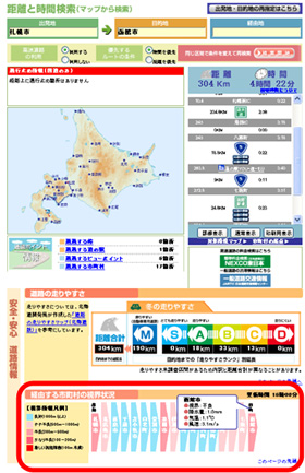 Provision of information on visibility in each municipality en-route in the "distance and time search" result (http://northern-road.jp/navi/eng/) |
Visibility assessment during snowstorms
In cold, snowy regions like Hokkaido, driving environments on winter roads vary greatly due to extremely slippery road surfaces covered with snow and ice, and poor visibility caused by snowstorms. Occasionally, roads are closed or multiple-collision accidents occur, and drivers are forced to drive under very harsh conditions.
When taking measures, such as the establishment of snow fences, snowbreak forests and visual guidances facilities, the provision of information via camera images and weather data, and the closure of roads, road administrators study and monitor visibility during snowstorms.
However, visibility value that is currently used for road management is
based on the meteorological definition, and its measurement or assessment
is not necessarily appropriate for road traffic.
Snow and Ice Research Team of CERI is conducting studies on visibility perceived by drivers during snowstorms for the purpose of presenting visibility measurement and assessment methods more suitable for road traffic during snowstorms.
Supply of visibility information during snowstorms
Since major cities are dispersed over an extensive area in Hokkaido, it often takes many hours to move between cities. Especially in winter, road surface and visibility conditions vary greatly depending on weather conditions, roadside environments and road structures.
To enable drivers to drive more safely under such varying winter driving conditions, research has been conducted on the influences winter driving environments and supply of such information may have on the driving speed, safety and comfort of drivers, and methods of providing information on winter driving environments have been examined.
The provision of information on visibility in each municipality en-route during snowstorms began on a trial basis this winter, as part of the distance and time search, which is the main content of the Northern Road Navi general road information site of Hokkaido.
This system, based on research results concerning poor visibility during snowstorms, estimates visibility during snowstorms using temperature, wind velocity, precipitation and other weather data, and provides the average visibility level of each municipality en-route on a scale of one to five.
We are planning to further improve the system through questionnaire surveys for users and verification of the visibility estimation accuracy.
(Contact: Contact: Snow and Ice Research Team, CERI)
Research on Sediment Flow in Mountain Rivers
- Effects of large gravels scattered on river beds -
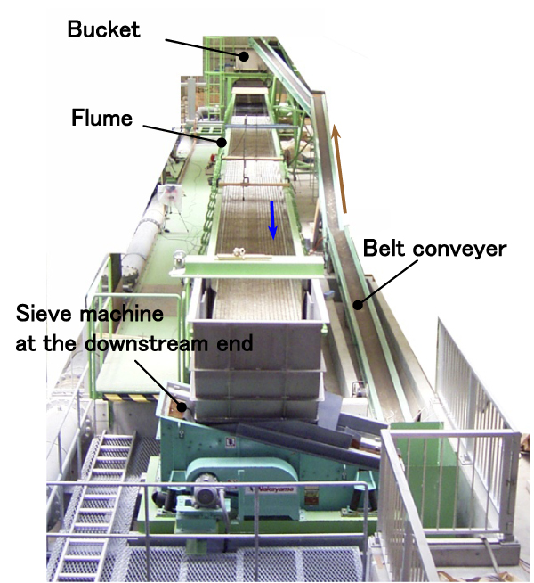 Figure 1. Variable slope flume with Sediment circulation System |
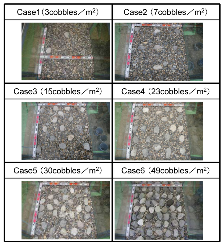 Figure 2. Placing of Large Gravels (Case 0 (0 cobbles/m2) |
Dams store silt, sand and gravel along with water. When a dam stores them,
its capacity to store water falls, preventing it from filling its water
storage function. To restore or maintain a dam's water storage capacity,
the River and Dam Hydraulic Engineering Research Team is researching technologies
to make silt and sand stored by a dam flow downstream, and in the future,
it will also be necessary to make gravels to flow downstream along with
sand. There remained some technical problems on sedimentation in mountain
rive. When gravels, and in particular large gravels, stopped by a dam are
supplied to a downstream river; specifically how will this change the shape
of the river channel or how will it change the grain size distribution.
Rivers flowing through mountains, where dams are constructed, are called mountain rivers. Characteristics of such rivers are bedrock protruding from and large gravels scattered on the riverbeds. Many of the large scattered gravels collapsed from mountainsides or riverbanks and were then supplied directly to river channel, with the result that the diameters of the gravels vary greatly from place to place. As stated above, there are many unclear aspects of the flow of sediment in such mountain rivers, and field observations are now being carried out at various places to develop a model which represents the sediment discharge where large gravels are scattered and to clarify the actual state of sediment flow. And model bed of mountain river was set up in a flume and flume tests have been performed, confirming the impact on sediment flow of scattered large gravels.
The tests were performing using the 30m long, 1m wide, and 0.8m high variable
slope flume with sediment circulation system shown in Figure 1. The sediment
circulation system includes a belt conveyor which returns sediment carried
down to the downstream end of the flume to the upstream end, making it
a channel which can be used for long-term stable tests. In the channel,
gravel with average diameter of 15mm was laid to a depth of 0.2m, and as
shown in Figure 2, the percentage of large gravels was gradually increased,
and the quantity of sediment discharge when water was supplied at a channel
gradient of 1/100 and depth of 0.3m was measured. In cases 5 and 6, the
material is not scattered, but these were set as extreme cases. The diameter
of the large gravels (cobbles) was 100mm, and these are not transported
under the above water flow conditions. As a result, placing only 3 cobbles
per 1m2 of the riverbed surface reduced the sediment discharge by 25% from that
when cobbles were not placed. In the future, the correctness of the evaluation
results and the impact on river channel shape will be studied further.
(Contact: River and Dam Hydraulic Engineering Research Team)