
FY2010 PWRI Symposium Held
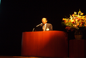 Opening remark by Dr. Uomoto, Chief Executive of PWRI |
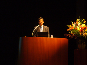 Special lecture by Dr. Futoshi Takiguchi |
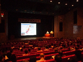 The Symposium venue |
.jpg) Program |
The FY2010 PWRI Symposium was held on Oct. 14th, 2010, at the Nippon Shobo Kaikan (Nissho Hall) in Toranomon, Tokyo.
The symposium was held to present the result of PWRI survey and research
as well as topic and trend concerning recent public works technologies
to engineers and researchers.
Some 460 people from private enterprises as well as public-service corporations
and local governments participated in the symposium of this year.
General lectures presented by PWRI’s researchers included disaster study
reports. These reports concerned a study on bridges affected by an earthquake
in Chile; landslides caused by torrential rains in Shobara City, Hiroshima
Prefecture; and flood of the Indus River in Pakistan. Other lectures addressed
technical standards and manuals in various fields and the technical backgrounds
behind them.
In addition, Dr. Futoshi Takiguchi, head of the Disaster Management Support Systems Office of the Japan Aerospace Exploration Agency, was invited to give a special lecture titled "Development and Utilization of Satellites: Viewing the Earth from Space."
A questionnaire survey conducted after the lecture harvested a variety
of comments from participants. Examples included, "I gained a much
better understanding of the sophistication, density, and global contribution
of Japan’s research," "I find the lecture to be useful in getting
an overall picture of PWRI’s research achievements each year," and
"The lecture presented an excellent opportunity to contemplate important
achievements." Among the themes participants said they would like
to see addressed in future symposium were, "Japan’s public works standards
on the global stage, and the excellent civil engineering technologies of
other countries," "examples of runoff analysis, flood analysis,
and flood prediction using satellite data," and "disaster reports
and the content of similar countermeasures in other countries." And
examples of comments participants submitted regarding PWRI included, "There
are undoubtedly topics that can be addressed in various other fields, and
I would like to hear PWRI discuss them at other opportunities," and
"I expect to see moves to promote the penetration of Japanese specifications
into other countries."
PWRI will intensify its effort to host even better symposium in the future. By doing so, PWRI will ensure that the symposium adequately serve as platforms for reporting on the superior research results achieved at its facilities.
(Contact: Planning and Management Division)
The Governor of Yamagata Prefecture presents PWRI with a certificate of appreciation for its response to a landslide in the Shimekake district
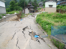 Photo 1: A village damaged by the landslide |
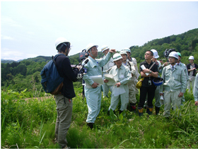 Photo 2: Mr. Fujisawa giving onsite guidance |
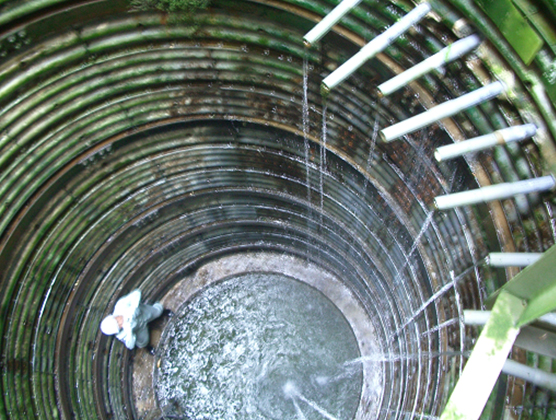 Photo 3: Groundwater being collected from catchment borings in a well (The photo is looking down from the top of the well. Catchment borings collecting groundwater can be seen on the right-hand side of the photo.) |
1. Presentation of a certificate of appreciation
In 2009, a major landslide struck the Shimekake district of Tsuruoka City,
Yamagata Prefecture. This landslide caused considerable damage to houses
and paddy fields (Photo 1). On May 29th, 2009, Mr. Fujisawa, Leader of
Landslide Research Team, PWRI (currently head of department in charge of
erosion research in the Nippon Expressway Research Institute Co., Ltd.)
was asked by the governor of Yamagata Prefecture to serve as an advisor
for landslide countermeasures in the Shimekake district. Mr. Fujisawa accepted
this appointment and endeavored to provide onsite guidance and advice concerning
landslide countermeasures. In recognition of Mr. Fujisawa’s activities,
the governor presented PWRI with a certificate of appreciation.
2. The Shimekake landslide
The formation and expansion of cracks thought to be behind the landslide were found within a residential area in February of 2009. By mid-April, landslide activity here began to gain momentum. The result was a large landslide measuring some 700 meters in length and 400 meters in width. It ultimately moved 7.8 meters horizontally and reached up to 1.6 meters in height1.
A look at the topography in the district reveals that its gradual slopes were formed by major landslides in the past, and that some degree of landslide activity had recommenced. The results of an onsite investigation showed that the district has a high groundwater level, evidenced in part by the existence of surface spring water, and suggested that this groundwater was a contributing factor behind the landslide. Consequently, PWRI determined that preventing rain and other surface water from penetrating into the ground as well as draining groundwater would be effective countermeasures. PWRI recommended that urgent action should be taken to construct surface water drainage channels together with water catchment wells and collecting borings (Photo 3) to collect groundwater.
3. Conclusion
PWRI’s Landslide Research Team intends to continue conducting research
to prevent landslides, and will work to support quick and appropriate measures
whenever landslide-related disasters occur.
1http://www.thr.mlit.go.jp/shinjyou/03_sabou/jisuberi/jisuberi.html#a (Shinjo Office of River website)
(Contact: Landslide Research Team)
We Are "Home Doctors" of Civil Engineering!
- "Bridge Inspection Workshop in Kamoenai" -
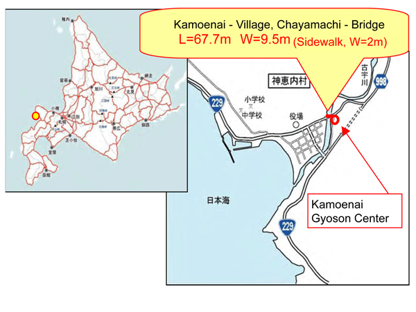 Fig. 1 Venue of the "Bridge Inspection Workshop in Kamoenai" |
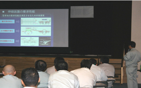 Photo 1 Basic course |
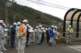 Photo 2 Participants listening to an explanation on the inspection points of the bridge |
CERI conducts technical consultation, technical guidance, dispatch of lecturers
and other activities for the Hokkaido government and municipality in the
prefecture as Home Doctors of civil engineering.
One such activity, the "Bridge Inspection Workshop in Kamoenai"
was held jointly with the Otaru Development and Construction Department
of the Hokkaido Regional Development Bureau on Oct. 13th. The workshop,
consisting of a basic course and on-site practical training concerning
bridge inspection, was held for those in charge of bridge inspection and
repair at the Otaru Development and Construction Department, Kamoenai and
other municipality in Shiribeshi Subprefecture.
That day, 42 participants attended the basic course on bridge inspection at the Kamoenai Gyoson Center in the morning, and practical on-site bridge inspection at the Chayamachi Bridge (Chayamachi village road) over the Kou River in the village in the afternoon (Fig. 1).
During the basic course, Senior Researcher Hiroshi Mitamura of the Structure
Research Team gave a lecture entitled "Basic Knowledge for Bridge
Inspection," in which he presented basic knowledge, such as forms
and structures of bridges, and described the importance of inspection according
to the types of bridges, and the dangers that may occur if bridges are
left untouched, while giving recent examples of damaged and collapsed bridges
(Photo 1).
During the on-site practical, the participants were asked to fill in the
inspection forms distributed in advance, while conducting simulated inspection
of the Chayamachi Bridge (Photo 2), and received an explanation from Researcher
Takashi Sato on the repair policy for damaged bridge parts and repair measures
depending on conditions.
The number of obsolete road bridges is expected to increase dramatically
in the future. To address this problem, a shift from conventional ex-post
measures to preventive repairs is imperative to ensure the safety and reliability
of road networks while promoting prolongation of service life and reduction
of costs.
In cooperation with the Hokkaido Regional Development Bureau, CERI (home doctors of civil engineering) intends to continue its support for the solution of civil engineering issues faced by municipalities in Hokkaido. Please feel free to consult us.
(Contact: Structures Research Team, CERI)
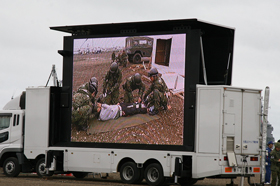
Flood in Pakistan’s Indus River basin in 2010
- ICHARM researcher joined an International investigation team -
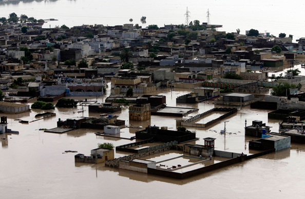 An aerial view shows Nowsheracity submerged in flooding caused by heavy monsoon rains in Pakistan on Friday, Jul. 30th, 2010. (AP Photo/Mohammad Sajjad) |
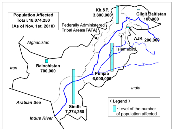 Flood affected districts (2010-11-1) Source: NDMA, PDMAs, GBDMA |
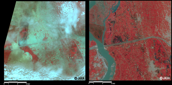 Enlarged images of the swollen rivers at Shadan Lund (324 square km, left: Aug. 6th, 2010; right: Oct. 2nd, 2009) provided by JAXA |
From the late July to August in 2010, Pakistan suffered a severe flood
caused by the worst monsoon on record. Even after that, the affected area
has continued expanding downstream over the lower Indus basin. Pakistan’s
National Disaster Management Authority (NDMA) reported that, as of Nov.
1st 1,984 people have been killed, about 1.74 million houses have been
either destroyed or damaged, and over 18 million people have been affected
in total.
According to Pakistan’ s Meteorological Agency (PMA), heavy rains continued
for four days during the last week of July over Khyber Pakhtunkhwa State
with a daily rainfall of 274 mm recorded in Peshawar on Jul. 29th. Extremely
severe rainfalls also hit Gilgit-Baltistan State located in Pakistan Kashmir,
causing widespread damage over the area. The flooding originating in those
areas then started spreading over the lower Indus River basin.
International organizations and aid agencies such as the United Nations
started emergency response efforts. UNESCO decided to send an investigation
team to Pakistan. ICHARM sent Chief Researcher Minoru Kamoto to join the
investigation team. The team discussed necessary future measures with the
Pakistani government in Islamabad and agreed that UNESCO would assist the
nation in flood forecasting and warning, ground water investigation for
drinking water, sediment-related disaster prevention measures for Indus’s
upper reaches in mountains, and understanding of the situation and causes
of the flood along with some other issues.
The Office for the Coordination of Humanitarian Affairs (OCHA) reported
that as of Nov. 4th several thousands of people are still stranded due
to the flooding and desperately in need of emergency supplies in Sindh
State, located at the lowest of the Indus River basin. The emergency projects
are also having difficulty in financial terms; only 40% of the project
cost has been raised even after three months since the flooding started.
To help these situations, review of the project plans and fair distribution
of emergency supplies are indispensible.
Since the late July, the discharge volume has increased in the Indus River immediately upstream of Tarbela Dam and in the Kabul River, a right tributary of the Indus River. The upper reach of the Kabul River is located in Afghanistan but no inflow has been confirmed from the territory, which leads to a conclusion that the discharge of the Kabul River increased in Peshawar because its swelled tributaries including the Swat River merged into Kabul at once.
We met at length in Islamabad with leading scientific figures and heads of institutions. As a result of this mission, an integrated nationally owned scientific plan has been developed for short and long term enhancement of the country’s capacity to manage floods and related geo-hazards. These actions include integrated flood and watershed management; groundwater resources for emergency situations, landslides and ground instability; and education and capacity building. Four priority early action areas have already been identified:
1) A study of the current floods to explain scientific reasons why they
became the worst and to identify ways in which such a disaster may averted
or minimized in the future.
2) Restoring degraded early warning systems especially for forecasting
flash floods.
3) Identifying locations for safe groundwater extraction in flood affected
regions.
4) Identification of landslide risks in relief camp areas to guide community
recovery.
(Contact: ICHARM)
We participated in the 2010 large-scale tsunami disaster drill
 Evacuation/rescue of a victim from a collapsed house |
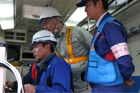 Team Leader Yoshihiko Ito (center) confirming the collapsed section |
 The River Engineering Research Team giving explanations of the panels Deputy Team Reader Okushi (second from the left) |
The 2010 large-scale tsunami disaster drill was held in Kushiro, Hokkaido,
on Saturday Oct. 16th, 2010.
This drill began after the tsunami disaster caused by the earthquake in the Indian Ocean off Sumatra on Dec. 26th, 2004, and has been held each year since 2005. This year, the training was held in the Kushiro region, where earthquakes occur frequently, with participants from many disaster-control organizations (10,000 from 65 related organizations). Participants from CERI included the Geological Hazards Research Team, the River Engineering Research Team and members of the Eastern Hokkaido Branch Office.
The scenario of the drill assumed a large-scale tsunami disaster caused
by an ocean-trench earthquake around the Japan and Kuril trenches. The
purpose of the drill was to ensure speedy and smooth emergency measures
at the time of a disaster by means of mutual cooperation among participating
organizations, and to reduce damage caused by earthquakes and tsunamis
by promoting dissemination of knowledge and education on tsunami disaster
control in local communities through practical training in cooperation
with residents.
Specifically, a variety of measures were taken on the assumption that the Pacific coast was struck by a large tsunami over 10 meters in height, generated by a massive 8.2-magnitude earthquake that occurred off the Tokachi coast.
The scenario of the secondary disaster drill assumed a vehicle to have
been involved in a large landslide that occurred on a national highway,
and that the Hokkaido Regional Development Bureau discovered it and made
a rescue request to the disaster headquarters. The Kushiro Fire Bureau
immediately dispatched a rescue party in response to the request, and the
Technical Emergency Control Force (TEC-FORCE) of MLIT monitored the rescue
by means of a small unmanned helicopter to make sure that the workers were
not struck by another landslide. From CERI, Team Reader Yoshihiko Ito,
who is a specialist in slope disasters, participated in the training, in
which he checked the collapsed section and surrounding slopes via the images
from the helicopter, and delivered his views to the TEC-FORCE concerning
sections with a high risk of rockfalls and further collapses. Expertise
acquired through our Institute’s past monitoring of damage conditions caused
by landslides and results of surveys on causes of collapse was also used
effectively in the drill.
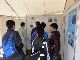
A display booth was established at the venue to exhibit panels about research on earthquakes and tsunamis conducted by our Institute.
(Contact: Planning Division, CERI)
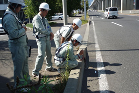
We accepted interns (work experience students) from Sapporo Technical High School
 Asphalt survey and road noise measurement |
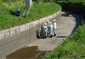 Frost deterioration survey on a side wall of an open concrete channel |
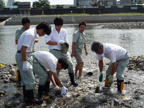 First-hand experience of rock bed girdle work |
We accepted three second-grade students from the Civil Engineering Course of Sapporo Technical High School again this year, for a 3-day internship (work experience) from Sep. 14th to 16th. The internship program is provided by the high school in cooperation with the local community, companies, government offices and the like, for the purpose of cultivating a desirable view of work and careers among high school students and to foster the abilities and attitudes required to make career choices on their own initiative.
September 14
On the morning of the first day, under the guidance of Senior Researcher
Abe and Researcher Mitamura, the students examined the condition of asphalt
and measured the road traffic noise on National Route 5 in Nishi Ward,
Sapporo, where there is a test construction section of low-noise pavement
using different types of asphalt mixtures. In the afternoon, they conducted
an experiment in which they measured/checked the corrosion condition of
reinforcing bars in ferroconcrete by means of the self-potential method,
under the guidance of Researcher Shitaya of the Materials Research Team.
The interns managed to cope with the work by cooperating with each other,
although they were puzzled by the measuring instruments that they were
using for the first time.
September 15
On the second day, the interns experienced the gathering of temperature data recorded in a data logger, and observed frost damage conditions using a variety of instruments, at the Kenwa main irrigation channel in Wassamu in northern Hokkaido, under the guidance of Senior Researcher Sato and Researcher Kaneda of the Irrigation and Drainage Facilities Research Team, which has been investigating frost deterioration on the side walls of an open concrete channel constructed in 1974.
September 16
In the morning, the students received a one-hour classroom lecture and
then experienced rock bed girdle work for two hours in a river as part
of nature-oriented river work under the guidance of Senior Researcher Ishiya
and Researcher Momonoe of the Central Hokkaido Branch Office of the Cold
Region Technology Promotion Division. The key to this work is combining
the load-bearing, arch and base stones properly by thinking from the viewpoint
of fish. The interns were fast learners and succeeded in completing a solid
girdle.
In the afternoon, the interns studied the difference in growth conditions of different types of trees in a riverside forest by the Toyohira River, together with Deputy Team Leader Researcher Yabe of the Watershed Environmental Engineering Research Team. All three interns struggled to identify the target trees in the survey, examining a picture book closely before actually examining the growth conditions.
Although it was a short program of only three days, hopefully it gave the students some ideas for making future career choices, by experiencing actual surveys and tests conducted by our Institute, as well as working in an organization in the society.
(Contact: Cold Region Technology Promotion Division, CERI)
Civil Engineering Day 2010 Opening to the Public
 A member of removed bridge on display at a research facility |
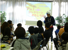 Hands-on experiment "Wow! Interesting Stories about Concrete" |
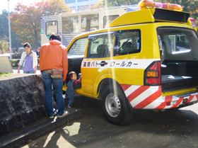 A work vehicle (patrol car) of the Kanto Regional Development Bureau on display |
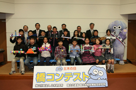 Award ceremony for the bridge contest |
 Science cafe Science cafe"Learning about landslide-related disasters" |
On Nov. 6th, the Civil Engineering Day 2010 Opening to the public was held jointly by PWRI and the National Institute for Land and Infrastructure Management (NILIM). This annual event is thrown to help a wide variety of people understand civil engineering projects. This year’s event was the 17th held thus far. A total of 782 people visited under clear blue skies.
Continuing with tradition, a number of annual attractions were presented,
including the opening of experiment facilities to the public and the holding
of a hands-on civil engineering experiment. Experiment facilities that
were opened this year were the pavement test field, the dam hydraulics
laboratory, the debris flow generator, and the test track. At each of these
facilities, experiments and demonstrations were conducted with detailed
explanations.
At the variety of hands-on experiments, an activity called "Wow! Interesting Stories about Concrete" were held. These events gave all visitors, both young and old, an opportunity to learn about civil engineering in a fun environment.
Other fun events for visitors of all ages included an display of work vehicles
held with the cooperation of four offices of the Kanto Regional Development
Bureau in Ibaraki Prefecture, an exhibition of excellent works entered
in a Cardboard Bridge Contest by fifth graders of elementary schools in
Tsukuba City, and a "science cafe" in which visitors learned
about landslide-related disasters while enjoying cups of coffee.
A questionnaire survey conducted as part of the event produced many opinions and impressions from visitors. As examples, some visitors said they liked the detailed explanations that were provided, while others expressed hope that PWRI would continue the event in the future. Undoubtedly, by explaining familiar topics at experiment facilities that aren’t ordinarily opened to the public, Civil Engineering Day 2010 helped people gain a greater affinity for and deeper understanding of civil engineering.
Civil Engineering Day is a rare opportunity for PWRI to highlight the importance
of its research and civil engineering projects. Knowing this, PWRI will
make every effort to further enhance the event’s quality in the future.
(Contact: Planning and Management Division)
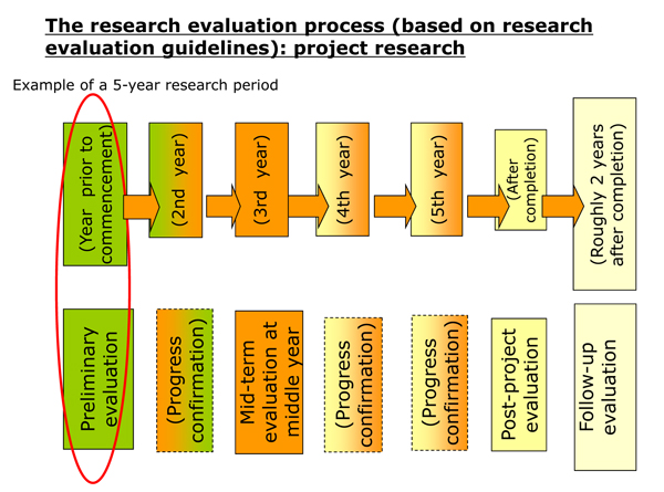
Meeting of the FY2010 PWRI Internal Evaluation Committee for the New Mid-Term Goals
 |
 |
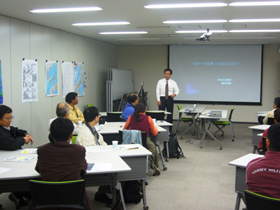
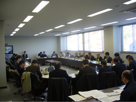 Meeting of the Internal Evaluation Committee |
The PWRI Internal Evaluation Committee met from Nov. 16th to 18th.
Medium-term goals that PWRI should attain are set by the Minister in charge
(MLIT, MAFF) and entrusted to PWRI. Medium-term plans are those for attaining
the goals, which were prepared by PWRI and approved by the Minister in
charge. This year marks the final fiscal year of the period for achieving
the goals. A new mid-term goals period will begin next fiscal year.
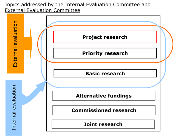
PWRI’s research framework was recently rearranged within the new mid-term
goals, and as a result, PWRI will implement research along three lines-namely,
"project research," "priority research," and "basic
research." Based on this new research framework, the PWRI Internal
Evaluation Committee met to hold deliberations on preliminary evaluation
for project research, which is the most important of the three research
lines. A total of 26 committee members took part in the deliberations.
The results of these deliberations by the Internal Evaluation Committee will be subjected to further deliberation by individual subcommittees of the External Evaluation Committee until mid-January of next year, and then undergo deliberations by the External Evaluation Committee when it meets at the end of January.
It should be noted that the Internal Evaluation Committee will hold deliberations concerning priority research and basic research over the course of four days; specifically, Dec. 7th, 8th, 14th, and 15th.
(Contact: Evaluation and Coordination Section)
Exhibit report: The Tokyo Industry Exhibition
The largest Japanese trade show for small to mid-sized businesses
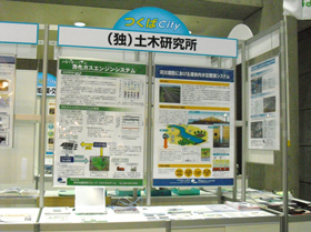 Exhibit booth (From the left-hand panel: Digestion gas engine system, driving-type water level gauging device, the lease system of facility) |
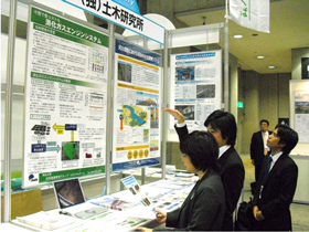 Visitors to the PWRI booth |
The Tokyo Industry Exhibition 2010 was held for three days beginning on
Nov. 3rd at Tokyo Big Sight. PWRI participated by exhibiting more than
10 PWRI’s new technologies and presenting its lease system of the facilities.
The exhibition was held for the purposes of displaying superior technologies and products, expanding distribution channels, developing corporate partnerships, and promoting information gathering and exchange. It attracted more than 50,000 visitors.
PWRI was trying to inform the visitors about the new technologies and the
lease system in order to promote their use in more fields outside of civil
engineering. Because the exhibition focused on the themes of "information,"
"environment," "machines/metal," and "medical
treatment and welfare," many of the people stopping by the PWRI booth
had no connection with civil engineering. And, even among those who did,
many did not know of the PWRI’s new technologies or lease system of the
facilities. Thus, the booth proved valuable in promoting greater awareness
of PWRI and its activities.
During the exhibition, some representatives of companies planning to enter
the civil engineering field indicated that they would consider business
that utilizes the new technologies. And there were many visitors who showed
interest in applying the PWRI’s new technologies and using PWRI facilities.
All in all, PWRI’s participation in the Tokyo Industry Exhibition proved
to be a significant opportunity to present its activities to people from
a broad range of fields.
(Contact: Facilities Management and Research Information Division)