
Publication of “The Estimation Method of the Sliding-surface Shape in a Landslide”

Fig. 1 Published book
(The Estimation Method of the Sliding
-surface Shape in a Landslide)


Fig. 2 Schematic diagram of
landslide line shape estimation
(click to enlarge)
What is a “landslide line”?
A landslide is a phenomenon involving the slope of a mountain or hill sliding down as soil mass. A landslide is considered to begin moving when a slip surface occurs in the slope. Since both the manner in which a landslide moves and the scale of the landslide vary depending on the shape of the slip surface, it is crucial to understand the nature of the slip surface in advance, in order to develop landslide control or response measures.
The length or width of a landslide is generally determined based on the distribution of cracks appearing on the ground surface. A slip surface, which occurs beneath the ground, cannot be visually examined directly from the ground. Therefore, the position of a slip surface must be determined, by means of a boring survey for example, prior to reviewing potential measures of address; and the shape of the slip surface is, in this case, estimated based on such survey results. A boring survey is a sure way of determining the shape of a slip surface, but takes many days to conduct. The implementation of emergency measures, however, requires swift estimation of the slip surface.
Under these circumstances, PWRI and six private companies have jointly worked on R&D of a method to safely and rapidly estimate the shape of a slip surface, based on the displacement measurement data on the ground surface. The outcome of our collaboration is a method for estimating the slip surface of a landslide by measuring deformation of the ground surface at several locations. Since this method involves two-dimensional calculations, the term “landslide line” is used instead of “slip surface.”
Features of the Book
The book summarizes the results of our joint work. It explains the landslide line calculation method and the landslide line estimation program, as well as how to measure ground surface displacement, using case examples.
Landslide line estimation program
The program for estimating landslide lines is available on the following website:
http://www.pwri.go.jp/team/landslide/kanrisya/slideline/suberisen_suitei.htm (in Japanese )
(Contact: Landslide Research Team)
Development of a Rockfall Retaining Wall Connected to a Pile Foundation

Fig. 1 Typical rockfall protection
structures (click to enlarge)

Fig. 2 Construction method for
gravity type retaining walls
(click to enlarge)

Fig. 3 Conceptual diagram of a rockfall
retaining wall with steel piles
(click to enlarge)
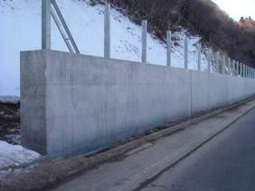
Photo 1 Construction site
Background of Technology Development
In the past ten years (2002 — 2011), an annual average of more than 1,000 slope disasters occurred in Japan. These disasters include mudflows, landslides and cliff failures caused by localized downpours or earthquakes, and they have resulted in tremendous suffering and damage. (Source: White Paper on Land, Infrastructure, Transport and Tourism in Japan, 2012)
Rock-fall protection structures (e.g., rock sheds and rockfall retaining walls) are built for protection from rockfalls on slopes (Fig.1). Rockfall retaining walls are built at the bottom or middle of slopes to stop falling rocks.
When the bearing ground is adequate for a rockfall retaining wall but its depth below the surface is not sufficient (Fig.2 (a)), a gravity type retaining wall is usually adopted from the viewpoint of economic efficiency. In building a gravity type retaining wall, replacement of soil in the bearing ground with appropriate material may be necessary when the bearing ground is too soft to support the wall securely.
Regarding soft bearing ground that extends very deep below the surface, a significant amount of soil replacement is necessary. Additionally, large-scale temporary works are needed to allow for traffic on the existing road, and excavation at the slope bottom is likely to induce slope failures. In this regard, research has been conducted toward developing techniques for reducing the scale of necessary works.
Outline of technology development
For the purpose of addressing the above-mentioned issues, a rockfall retaining wall that is connected to steel piles was developed. This retaining wall consists of 1)steel piles, 2)a reinforced concrete (RC) retaining wall that connects pile heads together, and 3)a two-layered absorbing system that is composed of RC slab and expanded polystyrene (EPS). The impact resistance of the rockfall retaining wall was verified through full-scale experiments at a CERI test site and through impact response analysis. Based on the results, a method of design and construction has been proposed.
This design and construction method brings three benefits:
1) Reduction in the earthwork volume
2) Shortening of work periods and savings in construction costs through reduction in the scale of temporary works that are built to ensure the safety of the construction work and the trafficability of the existing road
3) Maintenance of construction safety by reductions in the scale of excavation at the slope bottom
The construction method has been confirmed to have an advantage over conventional construction methods when the depth of the adequate bearing layer is 3m or greater.
(Contact: Structures Research Team, CERI)