
Regarding effects on river structures caused by river run-up tsunami

The structure in the center of this image
is a model based on a weir.

river run-up tsunami in curved part.
The breaking wave of the outer bank
can be confirmed.

using OpenFOAM. Reproduction of wave diffusion
and breaking wave are possible.
The tsunami that occurred in the Great East Japan Earthquake Disaster not only damaged coastal regions, but it also caused enormous damage even to river regions. With this great earthquake as a turning point, not only floods and surges, but also tsunami were established as being subject to systematic safeguards in river management going forwards. A tsunami that has penetrated a river will run upstream while changing the form due to interaction with the riverbed terrain, such as through a undular bore (a form where the end of the bore splits into small waves and the wave height increases) or breaking bore (a form in which the bore goes upstream while collapsing). Therefore, in order to calculate tsunami wave power, hydraulic characteristics must be ascertained according to difference in tsunami form. The River and Dam Hydraulic Engineering Research Team carries out research into calculation of the force of a river run-up tsunami acting on structures such as weirs and flood gates, etc. through two different approaches: a hydraulic model experiment and numerical calculation.
The hydraulic model experiment is based on the assumption of a tsunami, using a large-scale two-dimensional waterway (around 50m in length) to cause a bore by instantly pulling up a moveable gate installed in the waterway downstream (Fig. 1, Fig. 2). A gate model was installed in this waterway, measuring wave pressure (pressure from waves) acting on the gate, and examining the relationship between river run-up tsunami hydraulic characteristics and wave pressure as well as how the gate floated. Results of the experiment showed that within the scope of the wave pressure calculation method proposed for coastal regions, this could also be used for river structures. It was also found that there is a need to keep in mind the distribution form of the wave pressure water depth direction.
In fluid mechanics, a phenomenon like a river run-up tsunami, which drastically changes the form of the water surface, is known as a free surface problem. In order to deal with this problem, the team performs numerical calculation using OpenFOAM, an open source numerical fluid toolbox (Fig. 3). The InterFoam solver (which is packaged with OpenFOAM) deals with free surface problems, and this solver verifies the validity of numerical calculation by setting the conditions of the hydraulic model experiment and clarifies the fluid movement of the tsunami's internal structure, etc., which is otherwise difficult to measure in a hydraulic experiment. With verified data obtained from the experiment, temporal changes to the form of the water surface as well as the position of the breaking wave, etc. could be roughly reproduced, showing that this is a valuable tool in examining the effects on structures caused by river run-up tsunami.
(Contact: River and Dam Hydraulic Engineering Research Team, Hydraulic Engineering Research Group)
Clarifying the mechanisms of earthquake-triggered landslides
1. Introduction
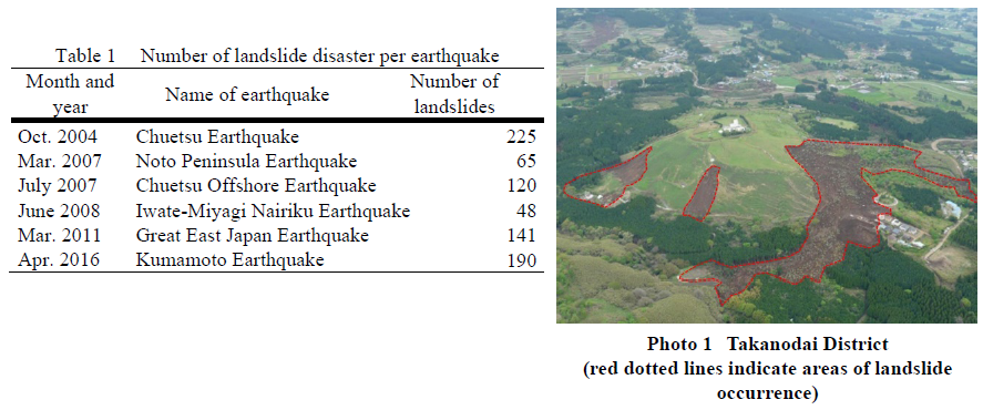
As shown in Table 1, in Japan major earthquakes of around magnitude 7 have frequently been occurring since the 2004 Niigata Prefecture Chuetsu Earthquake, and many earthquake-induced landslide disasters have been occurring. It is thought to be highly probable that at some point in the next 30 years, an earthquake will occur around the Nankai Trough, which will induce many landslide disasters widely. For reducing landslide disaster damage caused by earthquakes, there is currently demand for research that will help to reduce the damage.
In order to take precautions against landslide disasters, the Erosion and Sediment Control Research Group's Landslide Research Team is clarifying the mechanisms of landslide, carrying out research into appropriate monitoring-techniques and preventive countermeasures, and performing field surveys and cause analysis regarding landslides due to earthquake.
2. Survey contents
Landslides triggered by earthquakes are generally thought to be caused by unstability of the slope. Since there are still many unknown effects of seismic motion on the inside of the ground, it is important to survey and analyze landslides triggered by earthquakes.
Given the fact that multiple large-scale landslides occurred in Takanodai District, Kawayou, Minamiaso, Kumamaoto Prefecture due to the 2016 Kumamoto Earthquake (as shown in Photo 1), we conducted a field survey in the district. The Kyushu region, including Kumamoto Prefecture, has always been lively with volcanic activity, and the areas have a distribution of many geological features that were formed by volcanic product. Volcano sediment varies in color and hardness depending on factors such as the form of downward flow at the time of eruption.
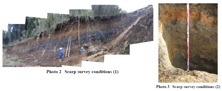
As shown in Photos 2 and 3, we surveyed sedimentation conditions of volcanic product in a vertical direction around the landslide scarp, and measured the hardness of the sediment. Through such surveys, it is possible to know which layer formed the boundary of the landslide as well as the age and physical characteristics of that layer. By using the survey results we are carrying out surveys and research to clarify the mechanisms of landslide.
3. Conclusion
We have also conducted a survey into the effects of countermeasure construction for landslides caused by the 2011 Great East Japan Earthquake as well as a survey of landslides caused by the 2014 Nagano Kamishiro Fault Earthquake, and are examining danger assessment techniques through seismic motion analysis, etc. Going forwards, we will proceed to clarify the mechanisms of earthquake-triggered landslides.
(Contact: Landslide Research Team, Erosion and Sediment Control Research Group)
Earthquake Resistant Performance of Embankment Structures Constructed on Peaty Ground
on the Tokachi River
after the Kushiro-Oki Earthquake

on peaty ground

for embankments on peaty ground
1. What is peaty soft ground?
The cold regions of Japan, such as Hokkaido and Tohoku, are widely distributed with peaty ground. Peat forms when dead, fallen phragmites and sedges accumulate without being decomposed in the low-temperature environments of northern lakes and bogs. Peat layers are generally 3m to 5m thick and are often underlain by thick layers of soft clay. Ground with such a structure is called peaty soft ground (hereinafter: peaty ground). Peaty ground is too low in bearing capacity to support structures. It subsides even under very small loads, and the subsidence of such ground is known to persist.
2. The mechanism of damage to embankments on peaty ground at times of earthquake
One cause of geotechnical disasters is liquefaction. In ordinary cases of liquefaction damage, structures on or under the ground are damaged when the sandy soil below the groundwater level liquefies. In recent years, there have been reports of significant liquefaction damage to embankment structures such as roads and river levees constructed on peaty ground at times of severe earthquakes.
The main cause of these liquefaction cases was identified: Embankments constructed with sandy material on peaty ground gradually subsided and sank into the peaty ground over time, and eventually the bottom of the embankment was below the groundwater level. Such embankments underwent liquefaction during earthquakes (Fig. 1).
Examinations on the mechanism such disasters have gradually come to reveal that the damage results from the combined action of embankment liquefaction, strength decrease in the area near the slope toe of the embankments, and lateral deformation of the peaty ground.
3. On the seismic reinforcement of embankments
Many embankments have been constructed on peaty ground, and techniques for improving the seismic performance of these embankments and mitigating damage have been called for. An example of such a technique that was examined in this study is the installation of gabions (baskets made of steel wire and filled with crushed stone and gravel) at the slope toe of embankments (Fig. 2). These gabions are expected to stabilize the structure by serving as weights, replacing part of low-strength portions, and allowing the water level to quickly subside. In examining these effects, the authors used centrifugal force loading tests in which results equivalent to those of field-scale experiments can be obtained. In the tests, a centrifugal force is generated that is n-times the gravity on a small model of 1/n of the actual structure.
The authors have also been making examinations to select appropriate parameters for a numerical analysis model or even to develop a new model that will be most appropriate for accurately predicting the damage to an embankment (i.e., deformation of the embankment).
(Contact: Geotechnical Research Team, Civil Engineering Research Institute for Cold Region)
Toward Restoration of Function of Creating Seaweed Beds of Coastal Structures
on coastal structure

at Suttsu Fishing Port
after the height-raising improvement
Coastal structures such as ports and fishing ports that have been developed with the aim of providing calm water areas are known to promote the creation of seaweed beds because that act similarly to natural reefs. In Hokkaido, coastal structures with the added function of creating seaweed beds have been constructed for more than 20 years. To give a coastal structure the function of creation seaweed beds, steps are constructed to make the water depth over them shallow. However, Isoyake, which means decrease or disappearance of seaweed beds, has become serious in recent years in Hokkaido, particularly on coast of the Japan Sea, where the water temperature in winter has been relatively high. It is necessary to take measures for Isoyake quickly.
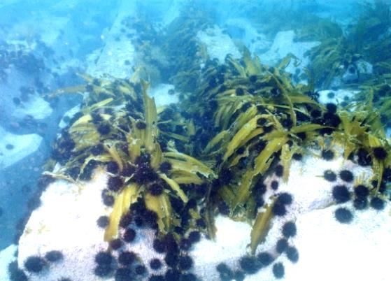
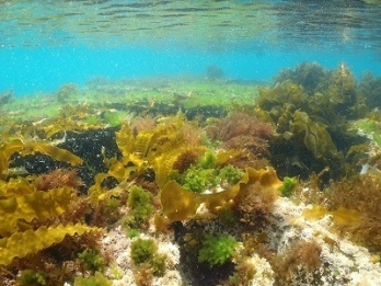
The main factor in Isoyake in Hokkaido is thought to be a overgrazing by sea urchins (Photo 1). High water temperatures in winter promote such overgrazing by sea urchins, because the amount of seaweed grazed by sea urchins exceeds the amount of seaweed that grows during the germination stage. By the way, grazing by sea urchins is suppressed when the water flow exceeds a certain velocity. Therefore,we proposed a height-raising improvement of a shallow step following the breakwater to controll overgrazing by sea urchins by altering the fast water flow and verified the effectiveness of this technique in an onsite demonstration experiment.
In 1997, the breakwater with the shallow-water area (a rear step) to be able to form seaweed beds was constructed at the Suttsu Fishing Port on the coast of the Japan Sea , Hokkaido. Seaweed beds were formed on the rear step in those days. However, it is necessary to take recovery measures for the formation of seaweed beds quickly, because the seaweed beds on the rear step has disappeared in recent years. In the onsite demonstration experiment, concrete blocks were installed on part of the rear step to alter to fast water flow and the influence of this alteration on the growth of the seaweed beds was investigated. In the the installed concrete blocks, faborable seaweed beds were formed after the water flow environment was altered by raising the height of the rear step. After this experiment, the rear step was improved by raising its height (D.L.-1.0m) along its total length (105m) (Photo 2, Fig. 1).
This improvement controlled seaweed damage from grazing by sea urchins, particularly during the seaweed germination period in winter. The favorable growth of seaweed was observed (Photo 3).
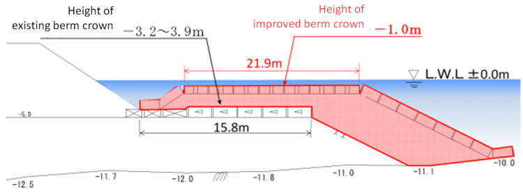
Fig. 1 The cross-section of the rear step following breakwater after the height-raising improvement
(Contact: Fisheries Engineering Research Team, Civil Engineering Research Institute for Cold Region)