In the early morning of January 17, 1995, the Hyogo-ken Nanbu earthquake occurred in the Hanshin area. The magnitude of the earthquake was 7.2 on the JMA scale. Extensive damage was developed to various engineering structures and others by intense ground motions. Damages to highway bridges, buildings and port facilities were summarized as follows.
The Hyogo-ken Nanbu Earthquake of 1995, with magnitude of 7.2, occurred at 0546 on January 17, local time (2046 Jan. 16, UTC). The hypocenter, determined by JMA, is located at 34B35.6'N, 135B02.1'E, in the northern part of Awaji-shima island, with a depth of 17.9Km. The focal mechanism of the main shock is a right-lateral strike slip, and the seismic rupture zone extended about 50Km in the SW-NE direction. This solution is fairly compatible with the tectonic stress in the southwestern part of Japan. A large number of aftershocks have occurred in a long narrow area along the seismic fault from the central part of Awaji-shima through Amagasaki city via Kobe city, the largest having a magnitude of 5.4. Seismic intensities of 6 (JMA scale) were observed at Kobe Marine Observatory and Sumoto Weather Station, near the epicenter. The maximum acceleration of ground motion was 818 gal, recorded at Kobe Marine Observatory. The most damaged areas, in which the intensity had the extreme value of 7, are several kilometers away from the fault system in Kobe and adjacent cities. Waveform analysis revealed that the largest moment release was in the shallower part on the Awaji-shima side and in the deeper part on the Kobe side. It is also estimated that the total moment was 2.7x10¹⁹Nm and the rupture propagated bilaterally and stopped in about 10 seconds.
The Geographical Survey Institute (GSI) investigated on the relation between geomorphic conditions and earthquake disasters in Hanshin area where remarkable damage had occurred parallel to piedmont of Rokko mountains. The investigation was conducted by using the 1:25,000 land condition map "Kobe" which had already been surveyed and compiled by GSI in 1995.
The Hanshin area consists of the hill ground and the low grounds where the urban area in the Kobe City and the Ashiya City is long and slenderly positioned between the Rokko mountains and the Osaka bay in the south. These mountains and low grounds are in contact with active faults. An alluvial fan and a minor terrace, etc. are consecutive and the coastal low ground and innings line up on the sea side parallel to the foot of the mountains. Most of all rivers becomes a raised bed river which flow from the mountains, and minute upland in the banks of river, continues to the out of river.
The result is as follows:
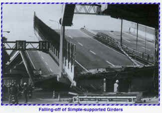
The Hanshin/Awaji Earthquake was the first earthquake that hit an urban area in recent years, and destructive damage occurred in highway bridges. Based on the information available at this moment, the following reasons may be tentatively pointed out:
Structures of quaywall at Kobe port are mostly gravity type such as concrete caisson and block with a few steel structured jetties. Clear differences were observed in damage according to seismic coefficient adopted in design and direction of quaywall face line. Quaywalls designed for small seismic coefficient of 0.10 to 0.15 were mostly damaged seriously while the high-resistant quaywall against earthquakes with the seismic coefficient of 0.25 at Maya wharf were not subjected to any significant damages. It was also observed that the damage of the quaywall directed to east-west is larger than that directed to northsouth. Gravity type quaywall slid offshore side reaching 1 m to 5 m and subsided 1 m to 2 m at the back site due to lateral deformation of quaywall. Buckling and derailing caused by crotch-tear generated by sliding of the quaywall were also observed for gantry cranes.
Liquefaction took place at most and limited parts of Port-Island and Rokko-Island, respectively, which were reclaimed by well traded Masa soil, Decomposed granite. Since Masa soil possesses a relatively high strength for liquefaction, catastrophic failure observed for structures in niigata earthquake did not take place. But settlement reaching 0.5 m in maximum was entirely observed and traficability was seriously damaged by liquefied sand covering the ground surface.
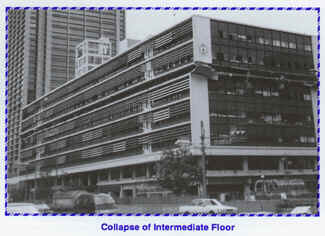
Reinforced concrete buildings and steel buildings are classified into three groups depending on their construction year. The first pending on their construction year. The first group is composed by the buildings designed before 1971 in accordance with the older code the second group include the buildings designed in accordance with the former code which was revised in 1971 after the great lesson of the severe damage of reinforced concrete buildings due to the 1968 Tokachi-oki earthquake. In this revision, some demands such as the shear design requirement in reinforced concrete buildings were drastically reinforced. The last group is composed by the buildings designed in accordance with the current building code, revised in 1981, in which the ultimate strength of the structure and member ductility's are considered as well as allowable stress design. The damage to buildings belonging to the second group is slight. Only some particular structures suffered damage in the buildings belonging to the third group. The damage of buildings by the Hyogo-ken Nanbu Earthquake is described in the following:
Japanese and U.S. members performed two joint damage investigations of the 17 January 1995 Hyogo-ken Nanbu Earthquake. The first investigation was performed during 23-28 January by 2 Japanese researchers headed by Dr. Yokoyama (PWRI), and 3 U.S. researchers headed by Dr. H.S. Lew (NIST). The second investigation was performed during 13-17 February by 13 Japanese researchers headed by Mr. Nakaoka (PWRI), and 18 U.S. researchers headed by Dr. R. Chung (NIST). These investigations were performed in response to a request from Dr. Wright, Chairman of the U.S.- Side Panel, to Dr. Iijima, his counterpart of the Japan-Side.
The first investigation was initiated immediately after the earthquake. At the site, the team grasped the extent of huge damage during the four-day field investigation. After that the team moved to Tsukuba. The outlines of the extensive damages were informed and discussed on January 27 and 28 at the Public Works Research Institute, Building Research Institute and Geographical Survey Institute.
The second full-scale investigation was conducted after the initial shock and confusion subsided. On February 13, a plenary meeting was held at a hotel in Osaka. At the meeting, the earthquakes characteristics and the damage it caused were explained to the U.S. researchers, and related topics were discussed. This was followed by a field investigation in Kobe separated into five small groups.
The Panel recognizes the importance of the need to continue to perform future joint post-disaster investigations to improve engineering and construction practices. The Panel also recognizes the importance of using the findings from these investigations in its ongoing work.
Finally, we would like to express our condolence to the victims of this natural disaster.
The 27th Joint Meeting of the Panel on Wind and Seismic Effects was held from May 16 to May 19, 1995, at the Public Works Research Institute, Tsukuba, Japan. The Panel on Wind and Seismic Effects is one of the 16 Panels in the U.S.-Japan Conference of Development and U.S.-Japan Natural Resources Program (UJNR). The principal objective of the Panel is to provide opportunities for exchanging research results related to revision of design criteria and for developing comprehensive measures and technical efforts to mitigate loss of lives and properties of extreme wind, earthquake, storm surge and tsunami.
The Panel has been established jointly in each country. The U.S. Panel consists of 54 members from 17 organizations including the National Institute of Standards and Technology, who serves as the U.S.-Side Chair. The Japan Panel consists of 69 members from the 7 organizations including Public Works Research Institute, who serves as the Japan-Side Chair.
The Joint Panel Meeting has been organized every year alternately in USA and Japan since the 1st Joint Meeting in 1969. The 27th Joint Meeting started with the Opening Ceremony in the morning of May 16. Addresses were received form three guests: Mr. Yasuo Kashima, Deputy Director-General for Engineering Affairs of the Economic Affairs Bureau of the Ministry of Construction (on behalf of Vice-Minister of Construction for Engineering Affairs), Mr. M. A. G. Michaud, Minister-Counselor for Environmental, Scientific and Technological Affairs of the Embassy of the United States of America, and Mr. Toshiaki Abe, Director for Office of International Affairs Division of the Science and Technology Agency (on behalf of Director of International Affairs Division of the Science and Technology Agency). Dr. R. N. Wright, Director of the Building and Fire Research Laboratory, and Dr. Takashi Iijima, Director-General of PWRI, then made addresses of behalf of the U.S.-side and Japan-side panels. Fifteen U.S. delegates and more than 70 Japanese participants took part in the meeting.
After the opening ceremony, technical presentations were initiated. Presentations and discussions were made in the five technical themes consisting of 1) Earthquake Engineering, 2) Wind Engineering, 3) Hyogo-ken Nanbu Earthquake, 4) Technology Needs for Emergency Response and Recovery Following Natural Disasters and, 5) Storm Surge and Tsunamis. Sixteen American and Eighteen Japanese papers were presented. These covered a wide range of technical fields including the damage caused by recent earthquakes, structural response and seismic design of building, bridges and dams, soil liquefaction and wind effects on bridges and structures.
The activities of the Two Task Committee Workshops, which were conducted after the 26th Joint Meeting (May 1994) under the auspices of the Panel, were reported. The Panel approved eight workshops for the coming year. After adopting the resolutions, the 27th Joint Meeting was closed in the afternoon of May 19.
During the week following the 27th Joint Meeting, U.S. and Japanese members of the Panel visited the following 12 technical sites: 1) Trans-Tokyo Bay Highway, 2) Kangawa Bridge, 3) Nagano Olympic Stadium, 4) Abo Tunnel, 5) Historic Post Towns and Temples, 6) Awaji Island - Epicenter of Hyogo-ken Nanbu Earthquake, 7) Akashi Kaikyo Bridge, 8) Matsumura-gumi Corporation Technical Research Institute, 9) Port of Kobe, 10) Kobe City Damage, 11) Hanshin Expressway Damage and 12) Kansai Airport.
The 11th Japan-U.S. Bridge Engineering Workshop was held at the PWRI on May 30 and 31, 1995. This workshop forms a part of activities in Task Committee (J), "Wind and Earthquake Engineering for Transportation Systems," of UJNR. The objectives of this Task Committee are to: 1) plan, promote, and foster research on the behavior of highway bridges when subjected to wind and seismic forces and 2) disseminate research results and provide specifications and guidelines based on the Task Committee's findings. Surface transportation systems play a vital role in the movement of goods and people. Highway bridges are specially influenced by the forces of wind and earthquakes because of their open exposure to those forces.
The scope of work includes:
The first Workshop was held at PWRI in 1984. After that, the workshop was held in Japan and U.S. alternately every year.
Seventeen U.S. bridge engineers, and 57 Japanese engineers participated in the 11th Workshop. Mr. James D. Cooper, Chief of Structures Division, Federal Highway Administration, was the Chairman for U.S. side and Dr. Koichi Yokoyama, Director of Structure and Bridge Department, PWRI, was the chairman for Japan side. The 11th Japan-U.S. bridge Engineering Workshop provided valuable exchange of technical information.
Seventy-four participants representing government, academia, industry, and private practice presented 32 papers in technical sessions. Main themes focused on research for seismic design, maintenance, wind resistant design, and new design. Especially, the damages caused by Hyogo-ken Nanbu Earthquake were shown, and had a extensive discussion on it.
The program coordinators concurred that the 11th Workshop was very fruitful for both sides, and that further cooperation is profitable. The program coordinators agreed that the 12th Japan-U.S. Bridge Engineering Workshop will be held in the United States in 1995.
The Port and Harbour Research Institute (PHRI) is a national research organization under the Ministry of Transport and is continuing its efforts to meet research demands related to ports and airports. The PHRI was established with four divisions in 1962. The PHRI present organization includes 7 engineering divisions, a computer center and an administration division. Those engineering divisions are Administrative Planning Division, Hydraulic Engineering Division, Marine Environment Division, Geotechnical Engineering Division, Structural Engineering Division, Planning and Design Standard Division, Machinery Division. The number of personnel is 204. The budget in 1994 was about 3,000 million yen.
Research Subjects in the Hydraulic Engineering Division are 1) Wave action upon structures, 2) Function and stability of maritime structures, 3) Coastal observation, 4) Protection from high waves, storm surges and tsunami, 5) Development of ocean energy utilization technology. In Marine Environment Division 1) Harbour hydrodynamics, 2) Utilization of coasts and littoral drift, 3) Environmental hydraulics and 4) Water quality improvement are studied. In the Geotechnical Engineering Division, various aspects of the engineering properties of soils have been studied by means of both laboratory soil tests and model tests. The main test apparatus is a Geotechnical centrifuge which was installed in 1980. Major research topics of Planning and Design Standard Division are 1) Design methods for port and airport facilities 2) Automating design works and execution control or facilities 3) System designs of ports and waterways and 4) Port and Airport development. The Machinery Division carries out research on development of craft and machinery used for various works such as port construction, marine surveying, environmental protection, and cargo handling.
In the Structural Engineering Division, studies on the behavior and stability of foundation soils and structures during earthquakes and waves and durability of materials are carried out. The development of new types of structures is also made. Major research topics are 1) Observation of strong earthquake ground motion in ports, 2) Stability of foundation soil during earthquakes (Liquefaction), 3) Earthquake resistance of port and Harbour structures, 4) Earthquake disaster prevention, 5) Structural mechanics of port and Harbour facilities, 6) Design of structures in deep water areas, 7) Materials and construction methods for port and Harbour structures and 8) Maintenance and repair of port and Harbour structures. In order to investigate the earthquake resistance of port structures model tests using the underwater shaking table are carried out.
Among the 17 U.S.-side Agencies, CDC is the newest agency and FHWA is one of the oldest agencies.
The Centers for Disease Control and Prevention (CDC), an agency of the U.S. Public Health Service based in Atlanta, Georgia, is responsible for promoting health and quality of life by preventing and controlling disease, injury, and disability. Within CDC, the National Center for Environmental Health (NCEH) is responsible for studying and recommending ways of controlling or preventing health problems associated with human exposure to environmental hazards. Within NCEH, the Disaster Assessment and Epidemiology Section is the scientific arm that responds to natural and technological disasters and their effects on people and the environment; the Emergency Response Coordination Group coordinates the overall CDC response to natural and technological disasters. CDC's response includes monitoring health conditions; detecting and investigating disaster-related mortality and morbidity; evaluating emergency preparedness programs and the effectiveness of various responses to disasters; and providing leadership and training for other domestic and international organizations concerned with limiting the adverse effects of disasters. CDC's ultimate aim is to develop and implement strategies to prevent or reduce illness, injury, or death related to natural and technological disasters.
One of the missions of the Federal Highway Administration (FHWA) is to identify new and improved ways to build and maintain the transportation infrastructure. Conduct of research and development in areas of structural, material, and pavement engineering are an important part of this mission. Within this part of the mission, FHWA has sponsored and conducted research on wind and seismic effects on bridges and other highway structures which has led to the development of the current earthquake design specifications for bridges used by all states. This research has been enriched by the FHWA participation in the UJNR Panel on Wind and Seismic Effects. Exchanges of information with Japanese colleagues over the 27-year history of the panel has provided an important avenue to share technology development in earthquake and wind engineering and gain from past disaster reconnaissance surveys.
1996 Calendar of Events |
|
| January | Workshop on Strong-Motion Data/Local Site Effects, Task Committee A, Yokosuka, Japan |
| April | A Tsunami Symposium, Task Committee I, Hawaii, USA |
| May | 28th Joint Meeting of the Panel on Wind and Seismic Effects, Gaithersburg, USA |
| September | Workshop on State-of-the-Art Reveiw of U.S.-Japan Research on Earthquake Engineering for Dams, Task Committee D, USA |
| 1996 | 2nd Workshop on Structural Control and Intelligent Material System, Task Committees C&G, USA |
EDITOR: Michio Okahara