| In
our periodical newsletter, we continue our focus on providing our national and
international partners and colleagues with up-to-date information on the progress
of our activities at ICHARM. | ||||||||||||||
| Issue No.6 | ||||||||||||||
| ||||||||||||||
| 1. Message from the Director | ||||||||||||||
| October 10, 2007 marked International Disaster Reduction Day. Twenty years ago, the General Assembly of the United Nations designated the 1990s as the International Decade for Natural Disaster Reduction (IDNDR), and the second Wednesday of each October as International Disaster Reduction Day. Since then even after IDNDR, the tradition is respectfully kept by its successor program International Strategy for Disaster Reduction (ISDR). While countries and organizations celebrated the day all over the world, it became a particularly special one for ICHARM to remember, because a new Master's program on water-related disasters was finally launched, closely coinciding with this internationally celebrated day. This new Master's program, entitled the "Water-related Risk Management Course of Disaster Management Policy Program," was jointly prepared by ICHARM/PWRI and the National Graduate Institute for Policy Program (GRIPS) with the support of the Japan International Cooperation Agency (JICA). On October 4 the program held an entrance ceremony at GRIPS in Tokyo, followed by an opening ceremony at ICHARM in Tsukuba. The first class in this program consists of 11 students from several Asian countries; three each from China and Japan, two from Bangladesh, and one each from Nepal, India and the Philippines. All the students participated in the ceremonies with strong determination to become experts in water-related disasters, except the one from India, who, unfortunately, will miss classes in October because of his involvement in restoration activity after a major flood his country suffered this summer. The program was designed to produce experts who are practical, problem-solving oriented and equipped with abilities to take the initiative in different situations, from planning flood management at the national level to building mutually assisting communities. Without much time to rest after a long journey from their home countries, the students began their classes. This program provides a total of 52 faculty members consisting of experienced professors, innovative-minded postdoctoral researchers, and experts in river management, water resources planning and other relevant fields. I believe it is fair to say that this is a dream Master's program in which to study disaster reduction. An ambitious curriculum is developed around four main pillars - fundamentals, exercises, field surveys and individual study for the Master's thesis. I truly hope that after experiencing hard working days together at ICHARM, young strong-willed students will take leadership roles to reduce water-related disasters in various parts of the world, while networking and sharing information and experiences with each other. This year the Nobel Peace Prize was awarded to former US vice president Albert F. Gore and the International Panel on Climate Change (IPCC). ICHARM, too, would like to give heartfelt compliments to those prize winners. Mr. Gore's movie "An Inconvenient Truth" has strongly impacted the progress of the global response to climate change. Subsequently addressed in Sir. Stern's report, the fourth IPCC report and the G8 Heiligendamm summit, mitigation and adaptation strategies for climate change have been commonly recognized as the most urgent issues in the 21st century. Now countries and organizations have started to globally undertake such issues. The mitigation/adaptation movement suddenly gained momentum. On September 6 the High-level Panel on Water-related Disasters, under the UN Secretary-General's Advisory Board on Water and Sanitation, held its first meeting in Tokyo. The panel was chaired by Mr. Han Seung-Soo, president of the Korea Water Resources Cooperation, with his vice chairs, Mr. Salvano Briceno, director of ISDR, and Mr. Loic Fauchon, president of the World Water Council. The members agreed on the importance of water-related disaster prevention for adapting to climate change. After discussing a range of issues, including indices for water-related disasters, promotion of flood forecasting/warning systems, and governance, the panel scheduled its second meeting next January in Korea. Besides regular research and educational work, ICHARM staff members are busily preparing for upcoming events: the "Flood Hazard Mapping" training course from October 29, the "ICHARM Quick Report on Floods 2007" on November 6 commemorating the completion of the ICHARM auditorium, and the Asia-Pacific Water Summit on December 3-4 in Beppu, Kyusyu. As the autumn season steadily deepens, ICHARM is ever busy preparing for meetings and managing ongoing activities. | ||||||||||||||
 Dr. Kuniyoshi Takeuchi Director of ICHARM
| ||||||||||||||
| 2. Recent Reports | ||||||||||||||
| i. Tsunami countermeasures in Kii Peninsula | ||||||||||||||
| In the coastal areas of the Kii Peninsula and San-riku district, tsunamis have caused severe damage. Two earthquakes, in particular, on December 7th 1944 (M7.9) and on December 21st 1946 (M8.0) caused many casualties and much financial damage. Major earthquakes are predicted to hit these areas in the near future. Local municipalities along these coasts have been constructing structural measures, formulating local disaster management plans and providing disaster prevention education. In addition, many neighborhood groups have been |
acting proactively for tsunami disaster mitigation. ICHARM plans to conduct the "Comprehensive Tsunami Disaster Prevention (CTDP) Training Course" in June or July 2008. ICHARM staff members in charge of the training course visited the Kii Peninsula to learn about the latest situations of tsunami countermeasures and to have interviews in local municipalities, so that a practical as well as effective training program can be developed. This article introduces some of the structural measures in the Kii Peninsula. | |||||||||||||
| | ||||||||||||||
|
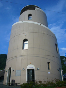
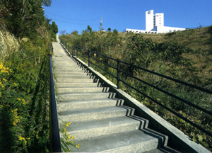
1. "Nishiki Tower" in Taiki Town, Mie Prefecture | ||||||||||||||
| The Nishiki district,
Taiki Town, Mie Prefecture has 1000 households with a population of 2500 and is
surrounded by sea and mountains. After the tsunami damage on Okushiri Island, the Nishiki residents started to prepare evacuation routes and evacuation sites, by which they can evacuate to higher grounds within five minutes. Because it is hard to evacuate to higher grounds in the area surrounded by the Oku River, the municipality constructed an evacuation tower called |
the "Nishiki Tower" in 1998. In the next year it was awarded by the Institute for Fire Safety and Disaster Preparedness. The tower is round and was built with consideration of tsunami power as well as collapse power of ships. The tower can accommodate 250 people, and there are three entrances. It is a four-story building and has an evacuation space on the rooftop, which is usually used for recreation. | |||||||||||||
 |
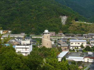 | |||||||||||||
| Nishiki
Tower | Nishiki
Tower area | |||||||||||||
|
| ||||||||||||||
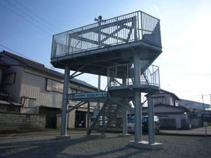
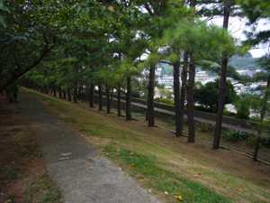
| 2.
"Tsunami Evacuation Tower" and evacuation route in Kushimoto Town, Wakayama
Prefecture | ||||||||||||||
| Wakayama Prefecture has prospected that in an event in which two major predicted earthquakes occur simultaneously, the first tsunami will hit Kushimoto Town within 6-14 minutes, and the height of tsunami may reach up to 4-8 meters at its highest. Considering these possibilities, the prefecture has identified areas in which it is hard for the residents to evacuate in time, and constructed four tsunami evacuation towers in those areas. The tower in the |
Kushimoto district, 6 meters high with a rooftop capacity of 70 people, is one of those towers. In 2001, the Omisaki neighborhood association constructed an evacuation route, using their own budget of 500,000 yen. The route shortened the evacuation time from 15 minutes to 6 minutes. This effort was awarded by the prime minister. | |||||||||||||
 |
 | |||||||||||||
| Tsunami
Evacuation Tower |
Evacuation route | |||||||||||||
|
| ||||||||||||||
| 3.
"Hiromura Levee" in Hirokawa Town, Wakayama Prefecture | ||||||||||||||
| Hirokawa Town, Wakayama Prefecture, suffered severe damage from two earthquakes on December 23rd and 24th of 1854. After the earthquakes, Mr. Goryo Hamaguchi, who is well known for the "Fire of Inamura (Inamura-no-Hi)," invested his own fortune to construct a tsunami dike, not only as tsunami prevention but also as a measure to counter unemployment. The dike, 5 meters high, 20 meters wide, and 600 meters long, was completed in four years and protected the town from the tsunami in 1946. Every November, "Tsunami Festival" is held near the dike. It has been held for over a hundred years and students of the 3rd grade in junior high school and the 6th grade in elementary school join the festival and remember the contribution of Mr. Hamaguchi. This festival has been a great opportunity to teach the importance of tsunami disaster mitigation from generation to generation. |
 Hiromura Leeve | |||||||||||||
|
| ||||||||||||||
| These
structural measures are just a few examples visited by ICHARM staff for the investigation.
More details will be introduced in our
website in the near future. | ||||||||||||||
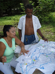
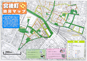
| ii. Community Based Hazard Maps in Ise City | ||||||||||||||
| At present, not only Flood Hazard Maps are published in 571 municipalities, but also several other kinds of Hazard Maps, e.g. land slide, earthquake and so on, are published in many municipalities. Those activities are mainly conducted by governmental and municipal organizations in almost all cases. However, there are some examples in which residents have made Hazard Maps and prepared for disasters by themselves. In this article, examples from the towns of Miyajiri, Ominato and Higashioizu in Ise City, Mie Prefecture are introduced. In these towns, residents conducted Town Watching, investigating the places of extinguishers, evacuation routes, evacuation centers, dangerous spots, etc. based on their plans, and made their own Hazard Maps. They can be called "Community based Hazard Map," as shown on the right hand side. Target areas are smaller and the information on the maps is more detailed; residents can easily recognize each house and wide and narrow streets. |
Community based Hazard Maps are made by residents to complement Hazard Maps by the government and municipalities and are a worthwhile attempt as a part of community based disaster prevention.
| |||||||||||||
| iii. The Preparatory Study
of the "Project for Strengthening of Flood Risk Management in Lai Nullah Basin" (Islamic Republic of Pakistan; August 19th-September 1st, 2007) | ||||||||||||||
|
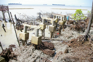
This past August, Mr. Sugiura, researcher of Hydrological Research Team, participated in the preparatory study team of the "Project for Strengthening of Flood Risk Management in Lai Nullah Basin" of the Islamic Republic of Pakistan. The Lai Nulla River flows downstream through the capital Islamabad with a basin area of 234.8 km2. A flood in July 2001 caused the worst damage, accounting for the death of 74 people. Japan has helped Pakistan install a flood forecasting and waning system consisting of a set of equipment for |
hydrological observation, runoff-analysis, and alarm announcement. Utilizing this flood forecasting and warning system, Pakistan is expected to take next steps to mitigate flood disasters in the future by making an evacuation plan based on its own local needs and conditions, establishing a cooperative system among related organizations and agencies, and educating residents about the danger of floods, flood warnings and evacuation through various opportunities, such as evacuation drills. | |||||||||||||
 |
 | |||||||||||||
| Downstream
view from Katarian Bridge |
Downstream view from Ratta Bridge | |||||||||||||
| ||||||||||||||
| 3. Research | ||||||||||||||
| i.
The 62nd Annual Academic Lecture Meeting of the Japan Society of Civil Engineers (Hiroshima; September 12nd-14th, 2007) | ||||||||||||||
| ||||||||||||||
| ii. International Seminar on Wetlands
and Sustainability 2007 (Johor Bahru, Malysia; September 4th-6th, 2007) | ||||||||||||||
| ||||||||||||||
|
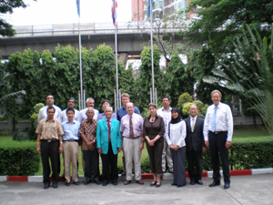
iii. The International Symposium on 2007 Basin Water Management Policy for Chao Phray River (Thailand) and Changjiang River (China). (Tokyo; September 6, 2007) | ||||||||||||||
|
The International Symposium on Basin Water Management Policy for Chao Phraya River, Thailand and Changjiang River, China hosted by the Public Works Research Institute (RWRI) was held in Tokyo on September 6. The symposium was part of the Japan Science and Technology Agency's project on water policy scenarios for the Chanjiang River in China. Nihon University, studying water policy scenario for the Chao Phraya River in Thailand, co-hosted the symposium. |
The purpose of the symposium was to discuss the latest policy issues and to advance scenario analysis to solve those issues such as land management on retarding basins. Three experts from China, Mr. Zhang Jinhua of the Chanjiang River Commission, Prof. Fu Xiang of Wuhan University, and Prof. Wang Yicheng of the China Institute of Water Resources and Hydropower Research, delivered presentations about two specific issues regarding the Chanjiang River; levee construction and management, and land use policy of retarding basins and its operation. | |||||||||||||
| ||||||||||||||
| 4. Training | ||||||||||||||
| i. ICHARM Launches a New Master's Program | ||||||||||||||
| ||||||||||||||
| ii. Flood Hazard Mapping Training Course, 2007 | ||||||||||||||
| ||||||||||||||
| iii. Introduction of "Comprehensive Tsunami Disaster Prevention Training Course" | ||||||||||||||
| ||||||||||||||
| ||||||||||||||
| 5. Attended International Conferences. | ||||||||||||||
| i.
Workshop of the ESCAP/WMO Typhoon Committee (Bangkok, Thailand; September 10th-13th, 2007) | ||||||||||||||
| ||||||||||||||
| ||||||||||||||
| ||||||||||||||
| 6. Report from Costa
Rica. (Ms.Tsuruta, former coordinator of FHM training course) | ||||||||||||||
|
It's a pleasure to write for the ICHARM news letter. My name is Toyomi TSURUTA, who is working as a rural development extensionist of the Japan Overseas Cooperation Volunteers (JOCV), in Ca?as, Guanacaste Province in Costa Rica. Before joining the JOCV program, I had worked as a training course coordinator of JICA Tsukuba, and was in charge of the Flood Hazard Mapping (FHM) course at ICHARM in October 2006. The FHM course left me great impression, as it put emphasis on participatory disaster-preparedness such as conducting two times town watching. While I was working for the FHM course, JICA was recruiting the overseas cooperation volunteers, among which I found a position in Costa Rica to work for the enhancement of disaster prevention at the community level. It attracted my attention, so I applied and got the position. Leaving for Costa Rica at the end of June, I have had 6-week language training in the capital, San Jose, and another month's training at disaster |
prevention agencies. After those trainings, finally I moved to my city Canas on Sept 4th. It is a relatively large city with a population of about 20,000. Many rivers and tributaries run around the city, and high precipitation in upstream area often causes inundation in the communities in downstream area. In order to comprehend the current situation, I and my colleague are visiting those communities everyday. Also we are planning for the activities at our municipality and schools for October 9th to 12th, which is the designated national week of education of disaster prevention in Costa Rica. As I have just moved in to Canas, it will take a while more to draw up my activity plan for 2 years. I will continue the investigation of the area in this year to find priority issues, and from the year 2008, will start working on the issues. Costa Rica is a beautiful country with abundant nature. I would love you to visit this country. | |||||||||||||
 |
 | |||||||||||||
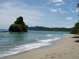
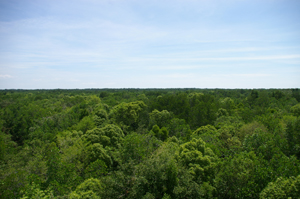
| Beaches
in Manuel Antonio National Park |
The photo was taken at a district of hotels, a community where its safety committee is the most active around Canas. In the past, the committee organized a workshop using a disaster imagination game with help from the National Committee for Urgent Disasters. | |||||||||||||
| ||||||||||||||
| 7. Coming Events | ||||||||||||||
|
ICHARM will hold a symposium entitled "ICHARM Quick Report on Floods 2007" at the ICHARM auditorium on November 6. In this symposium, a collection of quick reports on the most serious floods occurring so far this year will be presented by top local experts responsible for national flood research and management in China, and U.K. The reports will be followed by a panel discussion on global climate change and countermeasures each country is taking to mitigate flood disasters. | ||||||||||||||
|
The Asia-Pacific Water Summit will be held in Beppu, Oita, Japan, on 3rd -4th December 2007. The grand theme of the summit meeting is "Water Security: Leadership and Commitment." ICHARM is designated as the lead organization of Theme B "Disaster Management." | ||||||||||||||
| "East & Southeast Asia Regional Seminar on Flood Hazard Mapping 2008" will be held early February in China. Seminar period will be 3 days. | ||||||||||||||
|
Information | ||||||||||||||
Copyright (c) 2008 Public Works Research Institute
|