By Long Saravuth / Department Hydrology and River Works/MOWRAM
The source of Mekong River is located on the Tibetan Plateau of China, at an elevation of over 5,000 m. The Mekong flows through or forms the border of six countries: Southern China, Myanmar, Laos, Thailand, Cambodia and Vietnam.
The lower reaches of the Mekong (below Kratie) have a quite different hydrologic and hydraulic character. The flow patterns in this portion of the basin are primarily determined by hydraulic conditions, particularly tidal influences and water levels.
At Phnom Penh, the Mekong divides into the Bassac, the Lower Mekong, and the Tonle Sap River connect to Tonle Sap Lake. The Lake is the main feature in the Cambodian plain, of exceptional ecological, cultural and economic importance to Cambodia, the Mekong Basin and globally.
The Lake is the biggest fresh water lake in Southeast Asia with a mean dynamic surface area of 8,200 km2, from about 2,500 km2 at the dry season to over 15,000 km2 in some wet years. A unique phenomenon occurs annually. That is, the water flows into the Lake during May/June and the stored water flows back into the Lower Mekong and Bassac rivers in September/October. Water level in the Lake fluctuates by 7 to 9 meters.
Tonle Sap Lake and its vicinities include: the Lake catchments, the Tonle Sap river, the Chaktomuk area, the Cambodian Mekong delta, the TRANS-BASSAC and the CIS-BASSAC The function of this area in terms of flood management and mitigation, irrigation, fisheries, fostering of water resources and so on are complex and closely interrelated and not yet well understood to provide sufficient scientific background to support sound decision on resources management and development options.
People live along the river levees which are the highest ground dominating the flood plain. Often roads are built on those levees and they act also as flood protection dikes, Directly behind the levees. Floodwater brings sediment to fertilize the soil and nutrients to sustain the flood plain eco- system and the richness of the region biodiversities. At the end of the dry season, the immense flood plain shrinks into some deep ponds and mainstream of the Mekong, Tonle Sap and Bassac river system and starts expanding again as the Mekong flood water reaches the flood plain. .
In Cambodia, the traditional way of using floodwater for agriculture was the Colmatage canal systems, which divert water from major streams across the levees into the flood plain, those canals are man made or the improvement of the natural remnant of the river branches. Modern Colmatage canal are gated up and downstream and designed in such a way to provide maximum spreading of silt into the area. The gates provide water control for flood protection (early flood to allow proper maturation and harvesting) and keep water from receding (when water in the mainstream starts to recede) for dry season cropping. Dike systems were used to protect cities, town, and agricultural land from flooding, sometimes to create shallow reservoirs for dry season cropping and access road.
Pressure on land use is alarming, more and more flooded forest has been cleared for fire woods, and agricultural land as well as other required infrastructures such as roads, dikes, navigation and irrigation canals etc.
2. FLOOD ANALYSIS IN CAMBODIA DELTA
Estimate the amount of flooded water by dividing the area as follows.
Each zone should be divided more detail depend on the topography and water
flow, dike roads, canals etc.
l Zone 1: Tonle Sap Lake and its flooded area
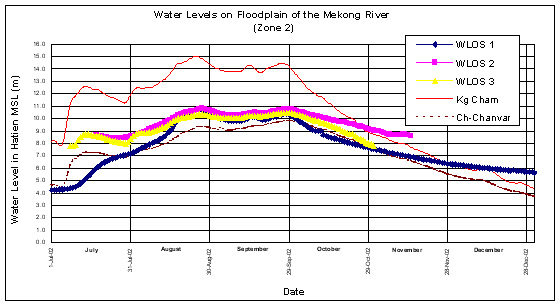
l Zone 2: Flooded area of the Mekong mainstream from Kampong Cham to Chaktomuk.
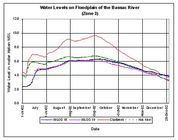
l Zone 3: Flooded area of the Bassac river from Chaktomuk to Chau Doc)
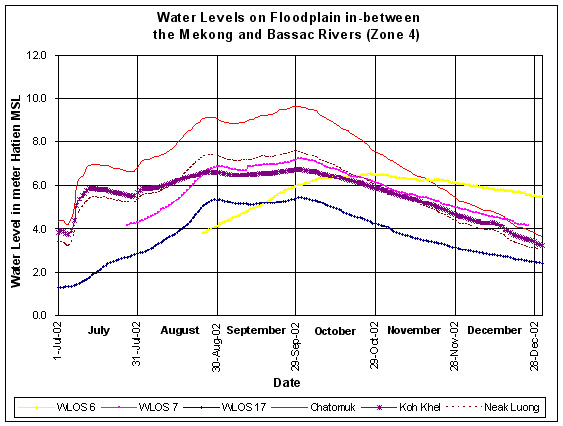
l Zone 4: Flooded area of the Mekong mainstream from Chaktomuk to Tan
Chau
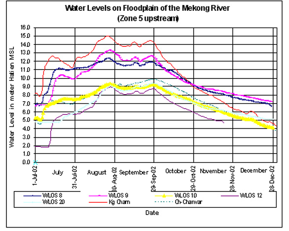
l Zone 5: Flooded Area of the left bank of Mekong mainstream from Kompong
Cham to Neak Luong
Cumulative Flow Volume for the period 10 July-17 November 2002
・ Kampong Cham Flow volum =364.941 MCM
・ NR70 Flow volume=4.906 MCM
・ Croy Chang Var Flow volume=304.937 MCM
・ Koh Norea Flow volume =266.548 MCM
・ Bassac Monivong Flow volume=51.268 MCM
・ Neak Loung Flow volume=284.329 MCM
Zone 2 Flow volume Sub area.1=5.073 MCM
Flow to Mekong=202 MCM
Flow volume Sub area.2=14.905 MCM
Flow to Mekong=636 MCM
Flow to Tonle Sap=19.837 MCM
Flow volume Sub area.3=6.987 MCM
Flow to Mekong=32.966 MCM
Flow to Tonle Sap=42.098 MCM
Flow volume Sub area.4=1.541 MCM
Flow to Tonle Sap=14.933 MCM
Flow volume Sub area.5
Flow to Mekong=37.299 MCM
Flow to Tonle Sap=34.299 MCM
Zone 3= 51.268 MCM
Zone4=7.214 MCM
Zone 5 Flow volume to zone 5=73.927MCM
Flow to Reverse=9.254 MCM
Flow to Mekong=365.066 MCM
Cumulative Flow Volume for the period 17 November-18 Jan 2003
・ Kampong Cham Flow volum =37.383 MCM
・ NR70 Flow volume=0 MCM
・ Croy Chang Var Flow volume=38.260 MCM
・ Koh Norea Flow volume =66.147 MCM
・ Bassac Monivong Flow volume=6.713 MCM
・ Neak Loung Flow volume=67.178 MCM
Zone 2 Flow volume Sub area.1=0 MCM
Flow to Mekong =34.059 MCM
Flow volume Sub area.2=4 MCM
Flow to Mekong=154 MCM
Flow volume Sub area.3=356+145 MCM
Flow to Tonle Sap=380 MCM
Flow volume Sub area.4=0 MCM
Flow volume Sub area.5
Flow to Mekong=4 MCM
Flow to Tonle Sap=119 MCM
Zone 3 Flow to Mekong 34.410 MCM
Zone 4=0 MCM
Zone 5 Flow volume to zone 5=3.087 MCM
Flow to Reverse=282 MCM
Flow to Mekong=2.324 MCM
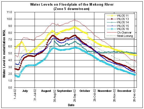
3. FLOOD HYDROGRAPH
4. FLOOD AND DROUGHT
The hydro-meteorological causes of floods in Cambodia are prolonged, heavy
rains on saturated soils. This leads to an increase in surface run-off
that can only slowly be discharged through the river system. Climate change
and global warming are likely to be contributing factors to increased
frequency and intensity of severe flooding and drought. Warmer water temperature
in the South China Sea may increase the number and intensity of typhoon.
Same estimates indicate that in the floodplain and the north part of Cambodia
could be threatened. However if there is lower rainfall in Cambodia as
a result of climate change, which is possible under some modeling scenario,
there may be decreased flooding and drought in some part of Cambodia.
As measured by the number of people killed by flood, history data suggest
that the frequency of serious floods is increasing in Cambodia. The impacts
of flooding on the poor are particularly significant. For example, rural
households generally have one hectare of rice land. The loss of 350,000
ha of paddy during the 2000 floods meant that a very large number of households
lost their primary asset for assuring their own food security, as well
as for generating cash income.
5. CONCLUSION
Floods have always been a part of life in Cambodia, exceptionally severe
flooding in the year 2000 and 2001 caused millions of riels worth and
claimed over 100 lives in Cambodia. Some of the causes could be ascribed
to unusual hydro-meteorological condition, but man-made factors such as
changes in land use were also implicated. Highlighting anew the need for
the floodplain approach to managing the problem of floods and drought
is :
・ Need Collecting data for estimated extent and duration of a major flood
event, river network and water bodies in the floodplain.
・ Need Collecting data for estimated extent and depth of a major flood
event, river network and water bodies in the floodplain.
・ Need Collecting data for study sub-catchments river networks and water
bodies.
・ Need technologies supporting flood mitigation efforts, through to establish
a new IHP centre in PWRI to undertake professional researches, practical,
training and information networking on Water Hazard and Risk Management.
・ To strengthen by the sharing of knowledge about flood through awareness-raising
activities.
・ To develop and promote in flood-prone areas.