
A Study on Suspended Sediment and Sand Transportation from Rivers to the Sea
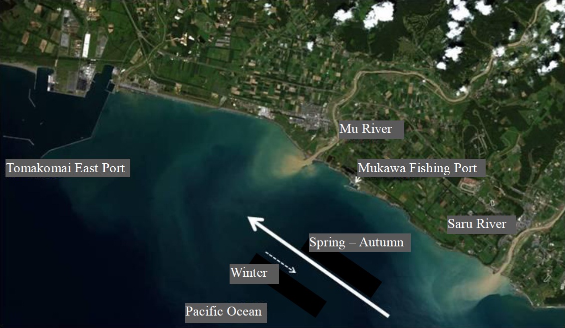
Suspended sediment flowing
from the Mu and Saru rivers
ALOS: Aug. 26 (photo courtesy of JAXA)
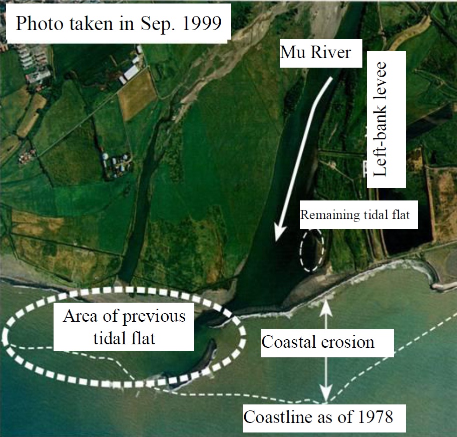
Tidal flat disappearance and coastal erosion
at the Mu River estuary
(Otsuka et al., 2008)
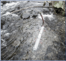
Suspended sediment sampler
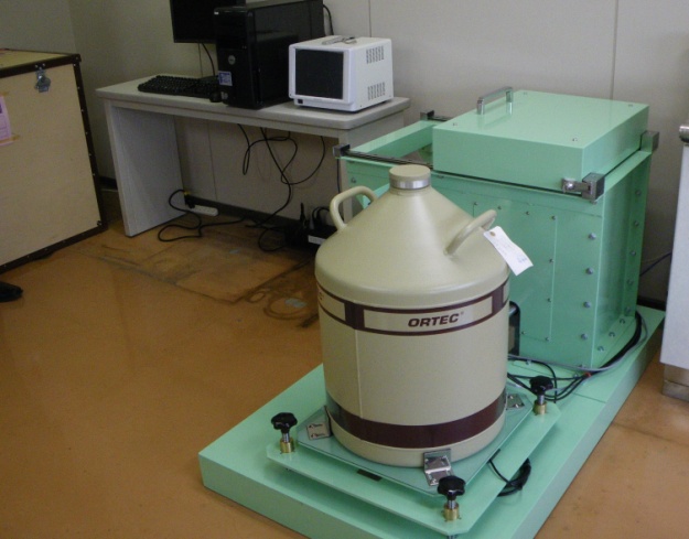
Gamma-ray spectrometer
Recently, a rising trend has been seen in the frequency with which localized
torrential rainfall occurs. Short periods of heavy rain cause an increase
in the production of suspended sediment made up of very fine soil particles
measuring several micrometers in diameter, and raise concerns about the
impacts of turbid water on rivers and the sea (as seen with the Mu and
Saru rivers in the photo shown here).
A decrease in the amount of suspended sand and other soil particles larger
than those of suspended sediment also causes problems such as tidal flat
disappearance and coastal erosion, as shown in the photo of the Mu River
estuary. The disappearance of tidal flats results in a significant loss
of habitat for migratory birds, while coastal erosion results in land loss.
Against this background, it is difficult to make judgments based solely
on the quantity of sediment transported in river water. Maintaining a balance
between the amount of fine suspended sediment and the amount of suspended
sand is important for the conservation of ideal basin and ocean environments.
Conventionally, sediment with a particle size of 0.1 mm or more has been
used in studies to address this problem. However, fine soil particles as
small as those of suspended sediment are predominant in the field. Once
the ground surface is eroded and fine particle sediment is picked up by
rivers, it is carried directly to the sea and discharged into the ocean.
For this reason, the movement of fine sediment should be observed based
on the implementation of appropriate measures. To this end, research is
under way to determine where sediment is generated, how it is transported
and how it accumulates on the seabed. Consideration of these factors is
based on the types and quantities of radioactive substances contained in
fine sediment, which vary with the location of production.
In this field, tubular instruments known as suspended sediment samplers
(as shown in the photo) are installed parallel to the direction of river
flow to collect suspended sediment and sand. A Gamma-ray spectrometer is
also used to determine the types and quantities of radioactive substances
contained in the samples collected.
(Contact: Watershed Environmental Engineering Research Team, CERI)
Development of hydraulic/water quality models and evaluation of the function of forest buffer zones
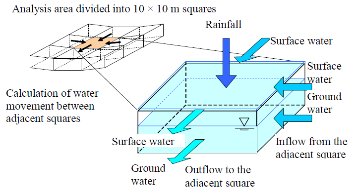
Fig. 1 Conceptual diagram
of the hydraulic (water flow) model
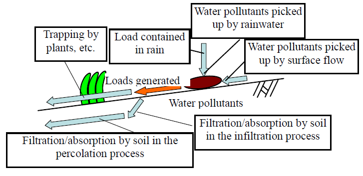
Fig. 2 Conceptual diagram of the water quality model
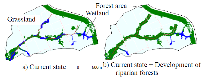
Fig. 3 Method for evaluating
the effects of riparian forest buffer zones
(Creation of basin simulation data)
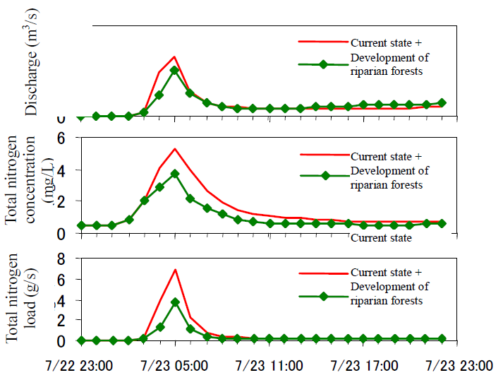
Fig. 4 Results of simulation for
the effects of riparian forest buffer zones
(Discharge, total nitrogen concentration
and load at the basin end)
Compaction of grassland soils using large-scale farm equipment causes a
reduction in infiltration capacity. This results in increased surface runoff
from rainfall, which carries fertilizers and other substances that impact
water quality into rivers. To combat this problem, forest buffer zones
(known as riparian forests) characterized by high infiltration capacity
are established along rivers to minimize the transport of water pollutants.
Our research team has developed hydraulic and water quality models that
enable calculation of rainfall-induced flow from grassland via riparian
forests to rivers to support evaluation for the effects of riparian forests.
The models and the results they produce showing effects on water quality
improvement are outlined here.
First, a hydraulic model to enable calculation of water flow in rainfall
events (Fig. 1) was designed. To support analysis, the model was divided
into a grid of 10 × 10 m squares to allow calculation for each step of
the process of water flow (surface water and groundwater) between each
square. Changing the parameter settings allows the representation of grassland
soils with low infiltration capacity, forests with high infiltration capacity
and other land characteristics. A water quality model to enable calculation
of water pollutant movement in the process of rainwater flow on and under
the ground (Fig. 2) was also designed. Such substances on the ground surface
are picked up by rainwater and washed away as the flow runs over the ground
surface. Rain itself also contains low levels of these substances. They
are regarded as generated loads in the model, and their levels are considered
to be reduced through filtration by plants and filtration/absorption by
soil. In this study, nitrogen was selected as the target water quality
parameter for analysis. Although ecosystems need adequate amounts of nitrogen,
excessive amounts have adverse effects on aquatic environments, such as
increased growth of water bloom.
These models were used to estimate the potential water purification effects
of riparian forests to be developed in a grassland basin. Based on current
information, data for simulation of the basin with the riparian forests
were created (Fig. 3). The forest zone width was set to 30 m on each side
in line with the dimensions of riparian forests developed in actual projects.
Analysis of data for rainfall events with and without these forests enables
comparison of the amounts of water pollutants (referred to as the load)
that flow from the end of the basin, and the difference can be attributed
to the effects of the riparian forests. Analysis showed that the peak values
of discharge and nitrogen concentration were lower for the basin with riparian
forests than for that without, and that the load was also significantly
reduced (Fig. 4). Based on studies relating to several basins, it was estimated
that riparian forests placed in a basin would reduce the amount of nitrogen
runoff from it in a rainfall event by 30% to 50% depending on the basin
size and rainfall amount.
(Contact: Irrigation and Drainage Facilities Research Team)