
Development of a Ground Improvement Method Featuring a Low Improvement Ratio for Purposes of Cost Reduction and Shorter Construction Period - ALiCC (Arch action Low Improvement ratio Cement Column) Method -

(a)Conventional ground
improvement method
(click to enlarge)

(b)Conventional method improved
to realize cost reductions
(click to enlarge)

(c)ALiCC method
(click to enlarge)
Fig.1 Comparison between the
conventional solidification method
and ALiCC method
1.Improvement of Soft Ground
Recently, the number of cases in Japan where structures including roads have been planned on very soft ground has increased. Therefore, when roads are built, they have to be constructed on soft ground.
When roads are built on soft ground, the soft ground may settle or slide sideways because of the load of the embankment and there are also cases where the load of the embankment may affect the buildings surrounding the road construction site. In order to prevent such problems, the ground is improved by solidifying the soft ground.
2.The Conventional Solidification Method and the ALiCC Method
One of ground improvement methods is to mix the soil with solidification materials like cement and allow the load of the structure to be transferred to the underlying bearing layer. With this method, holes are drilled vertically into the ground to pour cement into the holes and columnar cement piles are formed.
When an embankment is built on soft ground using the solidification method, the conventional procedure is to form columnar cement piles entirely in the ground under the embankment as shown in Fig. 1(a). Under this full improvement approach, all of the soil under the embankment is solidified, which makes it very unlikely to cause any settlement or sliding of the ground. However, it does require a lot of cement and work. Research has therefore been conducted to develop a new technique that supports the embankment with the least possible improvement. One possible solution is to form columnar cement piles only along the edges of the embankment as shown in Fig. 1(b). This option is cheaper, but it can cause serious settlement around the center of the embankment.
Consequently, we considered the method of laying out columnar cement piles sparsely in the ground under the embankment to realize a cost reduction and prevent the concentrated occurrence of settlement as shown in Fig. 1(c). The calculation method developed for this arrangement is called the ALiCC method. One of the features of this method is the formation of soil arches between the columnar cement piles laid out sparsely in the ground under the embankment. It reduces construction costs because it requires less work and materials than the full improvement method. When compared to the full improvement method, settlement may occur because this method still maintains soft soil in the ground. It does not mean, however, that settlement will occur intensively at certain limited locations. Therefore no major surface irregularities will occur on the road, and problems that may disturb traveling on the embankment will decrease.
The ALiCC method was awarded the 15th Infrastructure Technology
Development Award in 2013. It has a track record of use in 83 projects
by the MLIT and local governments to the end of FY 2013. The method is
also planned for use in various projects this year, including one run
by the Nagasaki River and National Highway Office under the Kyushu Regional
Development Bureau of MLIT. We plan to hold a briefing session for the
ALiCC method and a field tour with the cooperation of the Nagasaki River
and National Highway Office, thereby promoting the further diffusion
of the method.
(Contact: Construction Technology Research Team)
Forecast of Snowstorm-induced Poor Visibility and Provision of Snowstorm Visibility Information
Computer version:
http://www.northern-road.jp/navi/touge/fubuki.htm
Smartphone version:
http://www.northern-road.jp/navi/touge/sp/fubuki.htm
Mobile phone :
http://time-n-rd.jp/
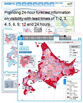
Figure 1 : Provision of snowstorm
visibility information, Hokkaido version
(Japanese only)
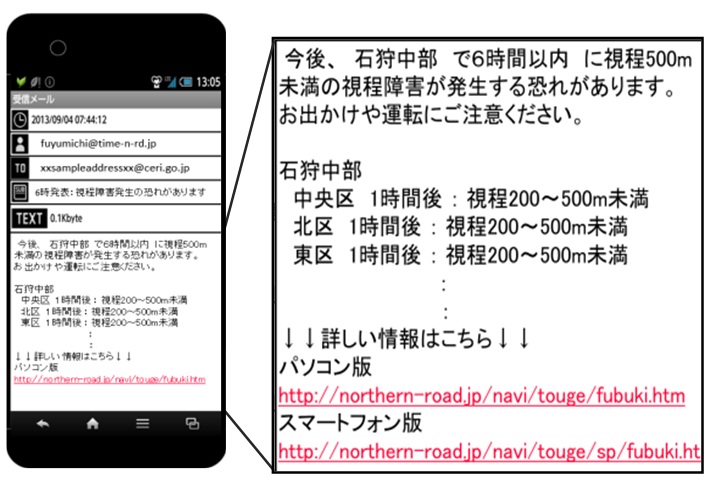
Figure 2 : Automatic delivery of e-mail
warnings in advance.
(Click here to register.)
(Japanese only)

Figure 3 : Hits on the snowstorm
visibility information system website
(click to enlarge)
Reducing the Risk of Blowing-snow Disasters
In Hokkaido, as in other snowy cold regions, drivers are exposed to very severe road environments, such as poor visibility caused by snowstorm. In response, snowbreak woods and snow fences have been developed. In recent years, however, blowing-snow-induced traffic hindrances have been occurring at locations that had been free of snowstorms, because of rapidly developing low-pressure systems. In some cases, existing facilities and methods are no longer effective in preventing blowing snow.
In light of this, it is thought critical to provide updated information on snowstorms toward helping road administrators and users to make sound decisions.
What is the snowstorm visibility information system?
The Civil Engineering Research Institute for Cold Region’s Snow and Ice Research Team has developed a method for estimating from climatic data the severity of poor visibility in snowstorms. In 2008/09 winter, the team began to provide information on road visibility levels on the website of the snowstorm visibility information system. Since February 2013, visibility forecasts have appeared on the website. The latest version of the system provides updates about road visibility in Hokkaido’s 203 municipalities, with basically one figure per municipality. Visibility levels are updated every 30 minutes, and visibility forecasts are updated every 3 hours between 6 a.m. and 9 p.m. The system provides lead times of 1, 2, 3, 4, 5, 6, 9, 12 and 24 hours. Visibility is classified into the five levels of “excellent” (visibility>1,000m), “slightly poor” (500-1,000m), “poor” (200-500m), “very poor” (100-200m) and “extremely poor” (less than 100m). The visibility levels are depicted in five colors (Figure 1).
An e-mail delivery service began in December 2013, aiming to warn users of expected poor visibility in advance. To use this service, users are asked to register their e-mail address, as well as the areas and visibility levels that they hope to be informed of. When poor visibility of the level and area specified by the user occurs, an e-mail alert is automatically delivered to their address (Figure 2).
Assisting Drivers in Decision-making under Snowstorms
Daily hits on the website of the snowstorm visibility information system are increasing yearly. There were 1,119 hits in 2012/13 winter, when the forecast information service was launched, and 2,416 hits in 2013/14 winter (December to March). The increase was partly because the service was covered by the media. Figure 3 shows daily hits in 2013/14 winter. On February 17, 2014, when road closures frequently occurred during snowstorms that occurred mainly in eastern Hokkaido, there were about 11,000 hits in total, a record high since the beginning of the service. From the soaring number of hits under worsening weather, it was understood that users rely on the visibility information to decide how to respond to adverse winter weather.
It is discouraging for drivers to drive on snowy roads with poor visibility. If they are able to know beforehand when, where and how severe blowing snow will cause poor visibility, then they will have a greater sense of security. The service is also available on recently popular Smartphones. We invite you to take advantage of this visibility information system when you plan to drive on snowy roads.
Consequently, we considered the method of laying out columnar cement piles sparsely in the ground under the embankment to realize a cost reduction and prevent the concentrated occurrence of settlement as shown in Fig. 1(c). The calculation method developed for this arrangement is called the ALiCC method. One of the features of this method is the formation of soil arches between the columnar cement piles laid out sparsely in the ground under the embankment. It reduces construction costs because it requires less work and materials than the full improvement method. When compared to the full improvement method, settlement may occur because this method still maintains soft soil in the ground. It does not mean, however, that settlement will occur intensively at certain limited locations. Therefore no major surface irregularities will occur on the road, and problems that may disturb traveling on the embankment will decrease.
(Contact: Snow and Ice Research Team, Civil Engineering Research Institute for Cold Region(CERI))