
Characteristics of Removal of Unregulated Chemical Substances in Sewage Treatment

Photo 1: Sewage treatment
experiment plant
(click to enlarge)

Photo 2: Survey at a sewage
treatment plant
(click to enlarge)

Fig. 1: Ratio of treatment effluent and
sludge with the amount of influent
set to 100%
(*: calculated in NP-converted
concentration)
(click to enlarge)

Fig. 2: LAS concentration of
influent and effluent water
at sewage treatment plant
by treatment method
(click to enlarge)
The Water Quality Research Team of the Public Works Research Institute conducts survey and research on the characteristics of removal of unregulated chemical substances in sewage treatment.
Two substances, or nonylphenol (NP) and linear alkylbenzene sulfonate (LAS), were added to the list of substances subject to control under the environmental standards for the purpose of preservation of aquatic life. NP and LAS are widely used in our everyday life; NP is applied to industrial surface-active agents, insecticides, bactericides, and mildewcides; and LAS to domestic synthetic detergents, agricultural emulsifiers, and cleaners' detergents. The effluent regulation is expected to be established for application to NP and LAS. Since sewage treatment plants are subject to effluent regulation, it is important to understand the removal characteristics of these substances in general sewage treatment. In this respect, the Water Quality Research Team conducts experiments to understand behavior at an experimental plant (Photo 1) and surveys the status of treatment at sewage treatment plants (Photo 2). The sewage treatment experiment plant is established at an actual sewage treatment plant and can provide useful data since experiments using actual sewage are readily conducted.
NP is known to be generated as surfactant nonylphenol polyethoxylates (NPnEO) are biodegraded under aerobic conditions into nonylphenol ethoxylates with short ethoxychain (NP1EO and NP2EO) and nonylphenol ethoxyacetic acid with short ethoxychain (NP1EC and NP2EC) to turn into NP by sewage treatment under anaerobic conditions. It is therefore important to also study NPEO and NPEC when NP is surveyed. The Water Quality Research Team conducted the behavior survey of NPs (NP, NPEO and NPEC) in the treatment process using the sewage treatment experiment equipment (see Fig. 1). While no removal of NPs occurs in the primary sedimentation basin, the ratio of NPs is reduced to about 32% in the secondary effluent, which revealed that about 68% of NPs are removed by activated sludge treatment.
A survey was also conducted on the LAS removal characteristics at 16 sewage treatment plants using various treatment methods in Japan (see Fig. 2). The LAS removal ratio is over 99% by the conventional activated sludge process and over 87% by other methods based on sewage treatment by contact of the sewage with biofilm under aerobic conditions (rotating, gravel contact, aerobic, contact, and trickling). High removal ratios were confirmed at plants that treat sewage using aerobic microbes including the conventional activated sludge process. The removal ratio of the type of treatment referred to as biological anaerobic-aerobic filter (anaerobic) tends to be somewhat smaller, or 81%, than that of the other methods.
The Team focuses on other substances expected to be newly subject to effluent regulation, and on pharmaceuticals that are currently indicated to possibly affect aquatic life and is conducting similar survey and research on those substances.
(Contact: Water Quality Research Team)
Field Survey using Unmanned Aerial Vehicle (UAV) for Clarification of Turbid Water Generation Phenomenon in Dam Reservoirs
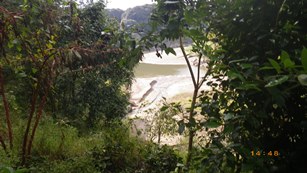
Fig.1 Field survey (visual inspection)
of turbid water of Tsuruta Dam

Fig.2 Small unmanned aerial
vehicle (UAV)
(click to enlarge)

Fig.3 Status of turbid water
generation during the field
survey of Tsuruta Dam
(UAV survey)
(click to enlarge)
1.Introduction
At a dam reservoir, there is a concern about generation and a release of turbid water, due to such phenomena as flood, movement of deposited sediments, or drawdown in water level.
The River and Dam Hydraulic Engineering Research Team is engaged in research for clarification and solution of phenomena related to generation of turbid water in dam reservoirs, in terms of environmental impact of dams
2.UAV-based Survey on the Status of Turbid Water Generation
The River and Dam Hydraulic Engineering Research Team has so far conducted field survey of turbid water in dam reservoirs with a visual inspection from around reservoir in order to clarify the phenomena related to turbid water (Fig.1). Some locations of dam reservoirs defy access of people for topographical reasons, which has thus prevented us from clarifying the phenomena in dam reservoirs in detail. Therefore, the Team decided to use an unmanned aerial vehicle (UAV) to make a field survey of a dam reservoir at the Tsuruta Dam in Kagoshima prefecture (Fig.2).
It is necessary to reduce the water level of the reservoir of the Tsuruta Dam when redevelopment work is conducted. The Tsuruta Dam operators reduce the water level of the reservoir by about 1 meter per day around Oct. every year and confirm that turbid water is generated by stir-up of deposited sediments and re-erosion such time of drawdown the water level. The Team took photographs of various parts of the reservoir with UAV and studied the status of turbid water generation when drawdown the water level. The survey revealed that turbid water occurred at a place that cannot be checked by visual inspection and successfully provided information instrumental to clarification of the mechanism of turbid water generation (Fig.3).
3.Field Survey with UAV
UAV has some drawbacks. For example, there are places where GPS cannot capture a satellite in some steep terrain near a dam, and the posture of the vehicle is unstable depending on the meteorological conditions. However, the use of UAV for aerial photography costs less than use of aircraft or a helicopter and when you have equipment at hand you can immediately obtain aerial photos. Use of UAV is highly appropriate for surveys like this when you wish to examine hydraulic phenomena that change conditions minute by minute.
In addition, UAV allows you to make a field survey of the conditions of the river channel upstream and downstream of the dam site relatively easily made. Therefore, it is applicable to surveys of various conditions, including the changes in an entire river channel before and after construction of a dam or the status of sedimentation in a limited area. We intend to make active use of UAV in the future while taking every possible action to ensure its safe use.
(Contact: River and Dam Hydraulic Engineering Research Team)
Surface Earthquake Fault Survey near the Kamishiro Fault
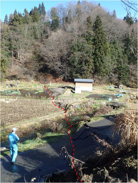
Photo 1: Surface earthquake fault
that displaced a road or a paddy
surface (red dotted line) at Shiojima,
Hakuba village
(click to enlarge)
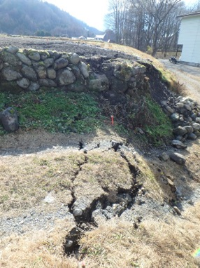
Photo 2: Fault displacement that occurred
at the same place of a small cliff at Oide,
Hakuba village
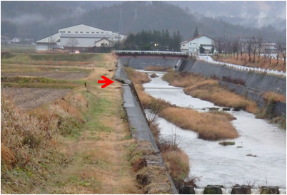
Photo 3: Surface earthquake fault that
crosses the revetment of a river
(red arrow) at Iida, Hakuba village
(The distance between both banks was
shortened as the surface earthquake fault
occurred at the river bed part in
the area toward the foreground of the
revetment crossing part.)
(click to enlarge)
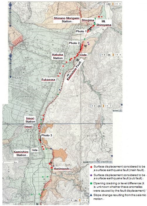
Fig. 1: Locations confirmed by the survey
to have caused surface displacement
(shown on the Geospatial Information
Authority of Japan Map (Active Fault Map
in Urban Area))
(click to enlarge)
Strain is accumulated in the superficial layer (earth crust) because of various factors including the collision of the plates. When strain is released, if a very deep fault moves, an earthquake immediately occurs. When the scale of that earthquake is large, the fault reaches the surface.
There are two ways an earthquake is supposed to influence a civil engineering structure: destruction by seismic motion and destruction by fault displacement. It is generally specified that destruction by seismic motion be handled by the seismic design of a structure. Destruction by fault displacement is generally coped with by avoiding an active fault, which is one that is confirmed to have repeatedly moved in the past and that is likely to move in the future, identified by survey prior to construction of an important structure such as a dam.
The Geology Research Team is planning to analyze the relationship between a fault that has apparently been confirmed to cause displacement upon the occurrence of an earthquake (surface earthquake fault) and the estimated result of the location of an active fault based on the judgment of the aerial photo and summarize points to note about estimation of the position of an active fault by aerial photos in order to improve precision of survey of the locations of active faults.
An earthquake with a magnitude of 6.7 occurred in the northern part of Nagano prefecture and shook the area at a seismic intensity of 6 lower on Nov. 22, 2014. According to the survey by Shinshu University and others, a surface earthquake fault was found near the Kamishiro Fault, which is a known active fault. Based on this information, a field survey was conducted from Nov. 26 to 28 and on Dec. 4 to confirm the relationship between the location of the surface earthquake fault and the topography.
The survey result confirmed that the surface active fault intermittently continued for about 7 km from a point about 300 m east of Mt. Shiroyama located east of Shiojima hamlet, Hakuba village, Nagano prefecture, to a point about 100 m west of Horinouchi hamlet (Fig. 1). This fault generally faces north-northeast to south-southwest, is a reverse fault with the eastern side upthrow (generated by compression of the ground), and has a maximum vertical displacement of about 90 cm (near Shiojima in Photo 1).
This fault occurred almost at the same place of a small cliff that existed before the earthquake near Oide (Photo 2) and Horinouchi. On the other hand, the surface earthquake fault occurred in a flat topography or in the river (for example, Photo 3) in the area near Shiojima and in the area between the southern point of Oide and the northern point of Horinouchi, in which it is presumed that the sedimentation or erosion of the river prevented precise estimation of the location of the Kamishiro Fault.
The survey results are planned to be fed back to research on improvement of estimation precision of the location of an active fault.
(Contact: Geology Research Team)
Toward the Introduction of Safe, Secure Roundabouts in Snowy Cold Regions
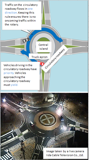
Figure 1 Diagram of RAB,
and a RAB introduced in Japan
(Iida city, Nagano Prefecture)
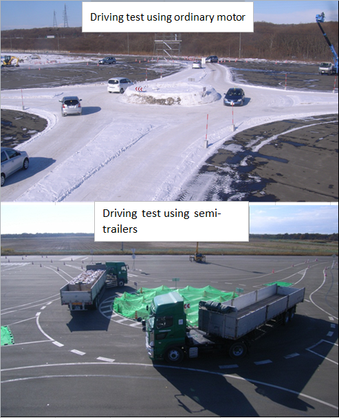
Photo 1 Driving tests at a RAB
(Tomakomai Winter Test Track)
1. Purpose of study on roundabout
A roundabout (RAB) is a circular intersection at which vehicles in the rotary part, called "the circulatory roadway", have priority over vehicles approaching that part (Figure 1: upper diagram). A RAB requires no traffic signals; therefore, it continues to function even when the power supply is cut off by disaster. A RAB suppresses entry speed to the rotary. Since the flow of the circulatory roadway is in only one direction, frontal impact accidents can never occur. For these reasons, RABs are said to be safer and have better trafficability than traditional at-grade intersections. Above all, RABs are very effective in mitigating serious traffic accidents such as fatal accidents, and they have been aggressively introduced since around 30 years ago, mainly in Western countries.
RABs have begun to be installed in Japan in relatively warm areas of Honshu (lower diagram in Figure-1). However no RABs have been installed in cold regions with heavy snowfall (snowy cold regions), and there are few case studies on installation in such regions. Therefore, at the Civil Engineering Research Institute for Cold Region, the Traffic Engineering Research Team, in collaboration with the Machinery Technology Research Team, is conducting studies on the development of structural standards for RABs, the assessment of trafficability and safety of RABs in winter, and management methods to maintain the functionality of RABs.
2. Assessment of trafficability and safety of RABs in winter
A portion of the studies conducted by the Traffic Engineering Research Team will be presented here. For RABs to be introduced to cold, snowy regions, it is essential to verify their trafficability and safety when winter road surfaces develop. Therefore, the Traffic Engineering Research Team installed an experimental RAB at the Tomakomai Winter Test Track and has been conducting driving tests using common passenger cars and heavy vehicles such as semi-trailer trucks. The test track is owned by our institute (Photo-1). Driving tests were conducted at this simulated RAB and at cross intersections using test vehicles (passenger cars) driven by subject drivers under dry conditions and compacted-snow conditions, for comparison. Data on various driving behaviors of the subject drivers and vehicles during driving indicate that it is easier for the driver to confirm the safety of entering the crossing at a RAB than at cross intersections, even under compacted-snow conditions. The data also show that, owing to the structure of the RAB, drivers tend to drive slower at RABs than at cross intersections. These findings demonstrate that RABs are intersections with a high safety level.
The Traffic Engineering Research Team is also doing research on RABs abroad, where RABs have been introduced earlier than in Japan, and in collaboration with other research institutes, the team is conducting studies to formulate standards for safe, secure roundabouts that are suitable for a disaster-prone country - Japan. In the future, studies will assess the trafficability and safety of RABs through driving tests that consider low-visibility conditions, such as night and snowstorm.
(Contact: Traffic Engineering Research Team, Civil Engineering Research Institute for Cold Region)