
Automatic system for tracking the behavior of wildlife
What does it take to track fish behavior in water?
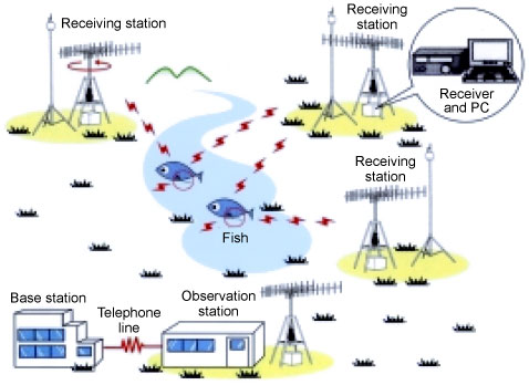 ATS system chart |
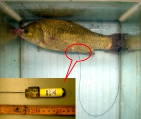 Crucian carp with a radio-wave transmitter attached |
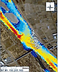 Movement of nigoi during a flood Gathering in an area with slow current (white dots) *Red: Fast current Blue: Slow current |
Have you ever thought that you’d like to understand how wild animals behave clearly and in detail? The Advanced Telemetry System (ATS) is a system that is designed precisely for this purpose.
The ATS attaches a radio-wave transmitter to a wild animal to track its
behavior. A number of receiving stations detect the direction from which
radio waves emitted from the transmitter are coming in order to identify
the animal's location. Currently, the system is capable of tracking a wild
animal's location roughly once every three minutes. While the system looks
simple at first glance, it must be remembered that radio waves emitted
from forests, grasslands, or rivers can repeat or show complex skipping
due to reflection or refraction. By analyzing complex radio-wave skipping,
the ATS makes it possible to automatically track wild animals.
The following presents the results of fish tracking in the Chikuma River as an example. Radio-wave transmitters were attached to fish (nigoi, a member of the carp family). The movements of the fish were then tracked for approximately six months. As a result, it was found that nigoi moved within a range of approximately 4,000 m².
A number of floods occurred during the observation period, providing some interesting data. Among them, it was found that fish avoid being swept large distances downstream by nimbly reacting to changing flow speeds in the river and selecting areas with slower speeds.
In this way, the ATS makes it possible to track in detail the behavior of wild animals—something that had been impossible with conventional wildlife survey methods. ATS technologies are expected to be applied in a number of fields. Examples include assessment of impact that changes in river forms caused by river improvement projects will have on fish behavior, and assessment of impact that changes in the natural environment that are caused by civil engineering projects will have on wildlife behavior (e.g., tracking the movement of fish that travel upstream in fish ladders).
(Contact: River Restoration Research Team)
“Kita-no-michi Navi”: A comprehensive source of information on Hokkaido′s roads
Research on advanced use of road information in Hokkaido
 Kita-no-michi Navi: http://northern-road.jp/navi/eng/index.htm |
 Mountain pass information complete with photographic images |
“Kita-no-michi Navi” (Northern Road Navi) is a comprehensive
website for road-information and guidance in Hokkaido that is operated
by CERI. Supervision of the site is provided by the Hokkaido Regional Development
Bureau, which is the body that manages major roads in Hokkaido; the Hokkaido
Prefectural Government; Sapporo City; the Hokkaido branch of the East Nippon
Expressway Company, Ltd. (NEXCO); and others. It was launched in July 1999.
The site provides roadmaps as well as information on mountain passes, functions for finding travel distances and times, information on “country signs,” and other services by linking road information provided by various road managers. The site supplies a variety of information that supports driving convenience, such as on “Michi-no-Eki” roadside stations and weather conditions, and is designed with consideration for seamless use of useful information when traveling by car in Hokkaido. In particular, the “travel distance and time search”function supports car-based sightseeing by providing distances and travel times from departure to destination as well as information on mountain passes and Michi-no-Eki, municipalities passed along the way, and roadside landscapes
The number of hits the site receives is growing year by year, reaching
a total of approximately 1.44 million (an average of 3,941 per day) for
all of FY2006. And the site is used for an average of 2.54 million travel
distance and time searches (averaging 6,965 per day) each year. It receives
a great number of hits during tourist seasons and times of severe winter
weather. On Oct. 24th, 2007, the total number of site hits on the site
since its inception reached 6 million.
From the very beginning, CERI has implemented surveys and research with an eye to applying Internet technologies in Japan’s road information field.
The results of a recent questionnaire survey that was conducted through
the site made it clear that providing winter-road users with information
using photographic road images can help them avoid hazards. We took this
analysis to launch an actual service that supplies winter-road information
through effective use of such images. Also, for people who are inexperienced
in driving on winter roads, we are providing an easy-to-understand “winter
road driving guide” that uses still and video images to explain important
points to remember when driving on Hokkaido’s winter roads. The results
of our research are used widely and it is also reflected in the Hokkaido
Regional Development Bureau's road-information systems.
Moreover, in June 2005, we responded to the recent increase in overseas visitors to Hokkaido by launching English, Korean, and Chinese (simplified and traditional) versions of the site. These sites have been accessed some 69,000 times as of October 2007.
(Contact: Scenic Landscape Research Unit or Snow and Ice Research Team, CERI)