
Rock-slope collapse test using centrifugal force
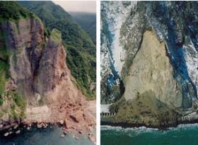 Left: 2nd Shiraito Tunnel Right: Slope collapse in Erimo Town (photo courtesy of the Hokkaido Regional Development Bureau) |
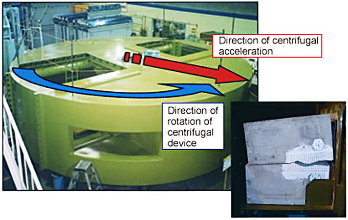 Centrifuge |
 The test involves a model test specimen with notches set at designated locations. The test is conducted until model weight and water pressure cause damage. In this way, the test suggests methods for assessing hazardous rocky slopes. |
In recent years, there has been a spate of rock collapses, among them collapses of Toyohama Tunnel in 1996, the 2nd Shiraito Tunnel in 1997, and a rock slope in Erimo Town in 2004. Such incidents threaten the lives and properties of the nationfs citizens, and result in road closures that cause inconvenience in peoplefs lives. In order to minimize rock collapse-related disasters as much as possible, CERI is advancing research on rocky slopes through model tests that use Centrifuge. The centrifuge is a machine thatloads a model and then spins it in order to generate centrifugal force within the model.
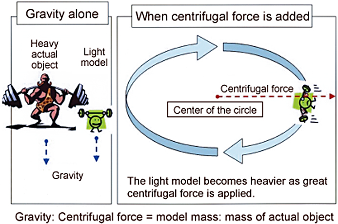
So, why do we go through the effort to conduct tests using the Centrifuge?
The truth is that, even if we build a model using the same material as
an actual slope, the much smaller load on the model slope means that its
degree of hazard cannot match that of an actual slope, and therefore the
model cannot recreate actual phenomena. In order to create a model slope
that matches the degree of hazard of an actual slope, it is necessary to
build the model using materials that are much heavier but have the same
strength, or to build the model at the same size as an actual slope. However,
building an actual-size model is not practical.
By adding centrifugal force, it is possible to increase weight on the model slope. In other words, it is possible to reproduce conditions that are similar to those of an actual slope by using the Centrifuge to centrifugalize the slope so as to simulate gravity. The centrifugal model test is based on this principle.
In the test, we set up a small model slope in the Centrifuge and then added centrifugal acceleration until weight equaled that of an actual slope. The device is capable of adding centrifugal force up to 100 times gravity. When it does so, the device is turning at a rate of 169 times per minute (effective radius of gyration: 3.5 meters). Using this test device, we are conducting tests on rock collapses under various conditions and using the results to analyze phenomena. We are currently creating methods for assessing degrees of safety of rocky slopes using the Centrifuge, and are seeking to make a contribution to the identification of hazardous slopes and measures for dealing with them.
(Contact: Geological Hazards Research Team, CERI)
Measuring accumulated snowfall
Research on snow-melt runoff characteristics in snowy cold regions
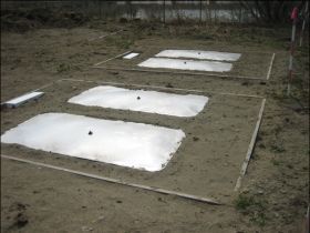 Installation of a snow-cover weight meter (1 meter x 2 meters; stainless steel) |
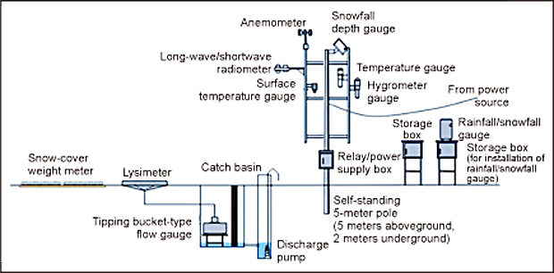 System for measuring snow cover and snowmelt |
 Continuous measurement of snow density |
Hokkaido is Japan’s foremost snowy cold region. Nearly half of all yearly precipitation in Hokkaido becomes accumulated snow, and this snow is an important water resource. However, recent global warming appears to be behind changes in the climate that include an earlier early snow-melt season and heavy rains in early spring. There are concerns that such changes could lead to future water shortages, flood damage, or other phenomena.
These concerns make it necessary to develop methods for safely using and managing snowmelt that take future climate change into consideration.
CERI is analyzing basic snow-cover and snowmelt mechanisms by surveying
snow cover amounts within targeted river basins. Using snow-cover weight
meters that can directly measure snow weight per unit area, the surveys
seek to gain basic information on snow cover.
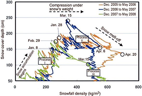
Traditionally, surveys to ascertain snow-cover weight have been conducted in February and March, which are the severest winter months. Such surveys require tremendous amounts of labor, as people must travel directly to the survey sites. And the need to deal with safety issues means that the amount of information that can be gathered is limited. Here, we are studying methods for safely and efficiently conducting surveys using snow-cover weight meters as a means of addressing these problems. Thus far, we have measured snow-cover weight and depth during the snow accumulation seasons from December 2005 to May 2008. The results have allowed us to grasp changes in snowfall density and depth.
We discovered the following series of characteristics:
- Snow accumulation and compaction from snowfall are repeated during the early snow accumulation season, and the amount of accumulated snow gradually increases (Process I).
- After maximum snowfall depth is reached, compaction under the snow’s own weight and changes in temperature cause changes in snow quality (lightly compacted snow → corn snow) that lead to increasing snow density (Process II).
- Toward the end of the snowmelt season, snowfall depth decreases as density remains roughly constant (Process III).
It should be noted that rain falling around April 20, 2006, makes it appear as if density increased. And the warm winter of 2008 resulted in decreased snowfall that shortened Process II.
Looking forward, we plan to ascertain the spatial distribution of the water equivalent of snow cover by introducing survey methods that utilize remote sensing and other such technologies.
*Remote sensing: A means for gathering information on topography, land features, physical features, etc., from a distance. In general, it refers to technologies for observing the earth’s surface from satellites and aircraft.
(Contact: Watershed Environmental Engineering Research Team, CERI)