
The NILIM and PWRI Great East Japan Earthquake Seminar was held in Tokyo and Osaka

Presentation in the debriefing session
Panel display
(provided by the Tohoku
Regional Development Bureau)
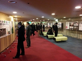
(Tokyo venue)
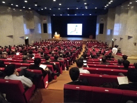
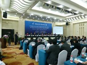
The debriefing session (Tokyo venue)
The seminar was held with the title "NILIM and PWRI Great East Japan Earthquake Seminar - What We See Now, One Year after the Disaster." NILIM and PWRI took action after the outbreak of the Great East Japan Earthquake, sending many researchers out to the affected areas immediately thereafter and continuing to provide various types of support, including the evaluation of the serviceability of road and port facilities indispensable for rescue, restoration, and rehabilitation activities, and technical assistance in the emergency restoration of those infrastructures. Now, one year having after the earthquake occurred, the two organizations held a debriefing session on what they have done and what the conditions have been so far, as well as what should be done in the future.
The seminar was carried out in the order of the genre of research or activities, such as the characteristics of damage to river levees caused by earthquake excitation, the results of verification of the effects of earthquake measures, earthquake resistance measures for river levees and the future direction of such earthquake resistant measures, restoration of sewage plants disabled by the tsunami, review on the functions of sewage treatment, and research and analysis to evaluate the effectiveness of seismic retrofit for bridges and revision of design specification based on lessens leaned from the earthquake.
This year, for the first time, the debriefing session this year was held in Tokyo (at Nissho Hall on Mar. 13th) and in Osaka (at L-Osaka on Mar. 21st). A large number of people (a total of 879, with 520 in Tokyo and 359 in Osaka) from private companies, local government organizations, and academia participated in the sessions. Panels showing the actions responding the disaster taken by the Tohoku Regional Development Bureau were also on display, and there were many people who were deeply interested in looking at them. The materials and data presented on the session days can be seen on PWRI’s website.
(PWRI’s website)
http://www.pwri.go.jp/jpn/news/2012/0328/index.html(Japanese Only)
(Contact: Planning and Management Division)
Technical Assistance Project with ADB
IFAS training in Indonesia
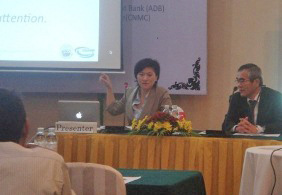
Workshop in Cambodia

Area of activity
(click to enlarge)
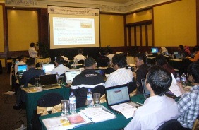
ICHARM of PWRI has been involved in Technical Assistance to enhanse the capacity to take action against floods under the regional technical assistance agreement signed with the Asian Development Bank (ADB) in November of 2009. This agreement stipulates that ICHARM provide human resources with the technical know-how and capabilities for flood management and that ADB bear the costs necessary for such service. It is a challenging task for ICHARM, which needs to show what they can do to fulfill the mission of the agreement. This report outlines this project, which is the first of its kind for PWRI, using overseas funds to provide PWRI’s activities.
(1) Introduction of the flood warning system and coordination with community disaster preparedenss (Indonesia)
With a catchment area of 16,100 km2, the Solo River is one of the major rivers in the eastern part of Java, which enjoys the most advanced economic growth in the country. We helped to introduce the Integrated Flood Analysis System (IFAS) developed by ICHARM and to provide education and training to the staff of the Solo River Office of Indonesia’s Ministry of Public Works. We also conducted activities to enhanse the communities’ flood preparedness systems, and helped them understand not only the importance of advanced technology in mitigating flood damage but also that of anti-flood measures on the community level.
(2) Formulation of a National Road Map through the quantified consensus building methodology (Bangladesh)
The lands of Bangladesh are mostly made up of flatlands that are 5m or less above sea level, and they frequently suffer a lot of damage from floods and storm surges. There are also many difficulties to alleviate in improving the country’s flood preparedness, including poor access to data across borders and inadequate telecommunications systems. An efficient flood early warning system requires practical, priority-based improvement and deployment. ICHARM analyzed the problems that were identified by questionnaire surveys conducted and workshops held for related governmental agencies, applied the quantified consensus forming methodology, and put together a National Road Map on flood early warning systems.
(3) Development of a general-purpose method for flood vulnerability assessment (Lower Mekong Basin)
While the Cambodian plains do benefit from some smaller floods, they also sustain damage to houses and rice paddies when big floods occur. ICHARM developed a method that can provide a rough picture of what damage a flood might cause by integrating readily available information such as rainfall and water level data and satellite topographic information, specifying the affected area and the depth of the flood waters, and estimating the damage to houses and to rice grown in the rainy season, which is a major agricultural product for this region. This is a multi-purpose method that allows changes to individual pieces of data, and it is expected that it will be developed further in the future.
This project is challenging activity whose implementation requires coordination with many organizations different from us in culture, history, and technical level, and which demands innovative results through the combined forces of all those organizations. It is hoped that through our experience with this project, PWRI and ICHARM will grow and become able to make greater contributions to the world. We are pleased to have your support as we intend to continue the project and cover more fields.
(Contact: ICHARM)
Cooperation Agreement Signed with Institute of Industrial Science, the University of Tokyo
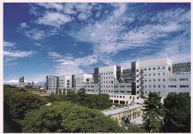
Institute of Industrial Science,
the University of Tokyo
(at Komaba, Meguro-ku)
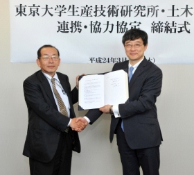
Signing ceremony
(Left: Dr. Uomoto, Chief Executive;
Right: Prof. Yashiro, Director General of IIS)

Lecture meeting at PWRI
(Left: Assoc. Prof. Ohara; Right: Prof. Meguro)
On Mar. 15th, 2012, PWRI signed a cooperation agreement with Institute of Industrial Science, the University of Tokyo (IIS) for the promotion of collaboration and cooperation at the Dai Building in Akihabara, Tokyo.
This agreement was concluded in order to facilitate the promotion of academia and science and technology and to apply research results toward enhancing the social good by utilizing the R&D capabilities and research assets of both institutes and by cooperating and collaborating on advanced and practical R&D and on the exchange and growth of the human resources who support the future.
After the agreement was signed, Prof. Yashiro, Director General of IIS gave a speech saying that he expects that providing IIS’s research results to PWRI will lead to solutions for various problems and that he hopes to promote the exchange of personnel, particularly of young people, to cultivate researchers with a broad mindset. Dr. Uomoto, Chief Executive of PWRI said that PWRI faces a lot of problems that need solving, as it is demanded that the institute quickly achieve results through their civil engineering research, disaster countermeasure expertise, and other fields. He hopes that PWRI will assimilate the viewpoints of IIS on areas that that PWRI does not already cover, such as nanotechnology research, so as to achieve breakthroughs and to be better able to meet the demands of society. The agreement drew a lot of attention as evidenced by the fact that as many as 12 journalists covered the signing ceremony.
Lectures to commemorate the agreement were held on Mar. 22nd (IIS) and Mar. 27th (PWRI). In the lecture at IIS, Dr. Tamura, Research Coordinator for Earthquake Engineering of PWRI, lecture about the damage to civil engineering structures by the Great East Japan Earthquake and the characteristics thereof. Dr. Osanai, Director of Erosion and Sediment Control Research Group of PWRI, lecture about measures against large-scale sediment disasters that have occurred due to recent intense rainstorms or typhoons. In the lecture at PWRI, Associate Prof. Ohara delivered a lecture entitled “The Effective Use of Earthquake Early Warning,” and Prof. Meguro explained what should be done for earthquake disaster prevention in the future from a broad perspective. We intend to continue exchanging research information and holding periodic joint lecture meetings and symposiums.
(Contact: Planning and Management Division)
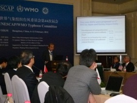
Participated in the 44th Session of the UNESCAP/WMO Typhoon Committee
Debriefing session on the activities of
the Hydrology Group,
facilitated by Chairman Kamoto
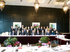
Participants in the Hydrology Group session
A scene at the venue
The Typhoon Committee is an intergovernmental organization established in 1968 under two United Nations organizations ? the Economic and Social Commission for Asia and the Far East (ESCAP) and the World Meteorological Organization (WMO) ? for the purpose of mitigating typhoon damage in the Asia Pacific region. Current committee members include 14 countries and regions (China, Hong Kong, Macau, the Philippines, Japan, South Korea, North Korea, Vietnam, Cambodia, Laos, Thailand, Malaysia, Singapore, and the USA), and the Secretariat is located in Macau (relocated from Manila, the Philippines, in 2007).
The representative of Japan is as follows;
Directorship of National service of Typhoon Committee Members;
Meteorological Component: Director-General Japan Meteorological Agency
Hydrological Component: Director-General, Water and Disaster Management Bureau
Ministry of Land, Infrastructure, Transport and Tourism
Disaster Prevention & Preparedness Component: Director of Disaster Preparedness and International Cooperation the Cabinet Office of Japan
The 44th Session of the Typhoon Committee was held from Feb. 6th to 11th in Hangzhou, China, and about 120 people from 11 of the 14 member countries or regions as well as seven observer organizations participated in the session.
On Feb. 6th, the typhoon damage mitigation activities conducted by the member countries in 2011 were presented. As for Japan’s report on activities in the hydrological field, the Director for Sabo Facilities Evaluation Analysis of the Sabo Department, Water and Disaster Management Bureau of MLIT presented a report on sediment-related disasters in the Kii Peninsula as a result of Typhoon Talas, emergency surveys conducted as per the Revised Sediment Disasters Prevention Act, the large-scale failure of the monitoring and warning system that covers the Kii Peninsula, and MLIT’s dispatch of pump trucks for the flood damages in Thailand. (The meteorological part of the report was delivered by Forecast Department and the disaster prevention part was prepared by the Cabinet Office and read by the Meteorological Agency staff instead.)
A science lecture meeting was held on the 7th, and each WG had its own meeting on the 8th.The Hydrology Group confirmed the progress made in 2011 on the activities of the ongoing typhoon damage mitigation project, and discussed the 2012 action plan under the chairmanship of ICHARM Chief Researcher Kamoto. The meeting was joined by 27 participants from 8 countries, ESCAP, and the Secretariat of TC.
In the Hydrology Group, a hazard mapping project for sediment-related disasters and a project to establish local flood disaster preparedness indices are currently underway under the leadership of Japan. A new project to formulate a common form for reporting sediment disasters is also planned to be conducted.
The results and future activities were discussed at the general meeting on the 9th and 10th. The Hydrology Group also presented a report on the progress of its activities in 2011 and on its 2012 action plan, which was approved. The final report of the Typhoon Committee session was finalized on the 11th. The Kintanar Award, an accolade which as of last year is to be presented to an organization or person for their great contributions, was given to the National Meteorological Center of the China Meteorological Administration and the Korea Meteorological Administration.
(Contact: ICHARM)
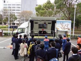
Open Facilities for the 53rd Science and Technology Week
Visitors reliving the great temblor of the 3.11
Earthquake in an earthquake simulation vehicle.

Staff explaining the current status of
bridges and what PWRI does to them.

Staff explaining earthquake-resistance
measures in front of the large 3D shaking table.
Science and Technology Week were established in order to cultivate the public’s understanding of and interest in science and technology and to stimulate science and technology in Japan. Various science and technology events are held all over the country during this period.
The 2012 Science and Technology Week were held from Apr. 16th to 22nd, and a variety of events took place around Japan. In Tsukuba, 40 research institutes participated in the event. On Apr. 20th PWRI and NLIM jointly opened their facilities. Despite the cold weather, 216 people including students visited the facilities.
At the opening of the facilities, visitors were offered the opportunity to experience high-speed driving at the Test track and a bus tour of the experiment facilities. Visitors were also able to see landscape simulation and a display of panels showing damages from the Great East Japan Earthquake. An earthquake simulation vehicle, which was rented from Ibaraki Prefecture and used with the cooperation of the Tsukuba Central Fire Department, was used to allow participants to experience a temblor. This vehicle was donated by the Kanto Regional Postmasters Association to Ibaraki Prefecture on Mar. 30th. It was the first time that this vehicle has been open to the public in such an event. The vehicle simulated the 2011 off the Pacific coast of Tohoku earthquake which was real seismic wave, and some visitors who experienced it cried out.
On the Test track, the staff explained to the visitors the institute’s research on ITS (Intelligent Transport Systems) technologies and noise control as well as other road-related research. The visitors walked up the 28-degree slope of the bank on the track and then got on a large bus to experience a high-speed test run at a velocity of 120 km/hr.
On the bus tour of the experiment facilities, topics such as the paving history, bridge maintenance, the seismic resistance of structures, the other activities of both institutes, and the problems they’re facing were introduced. Students earnestly took notes on the research on roads and bridges, objects they are always using without paying special attention, and general participants also showed great interest, nodding in appreciation while they listened.
PWRI intends to proactively conduct citizen-friendly events, including the opening of facilities to the general public, to help as many people as possible understand our research and activities.
We regularly accept requests for facility visits outside the public opening period, and we welcome many visitors to our facilities. (Please contact our General Affairs Division to request to visit.)
(Contact: General Affairs Division)
Snowmelt and Landslides
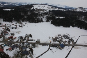
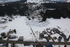
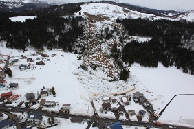
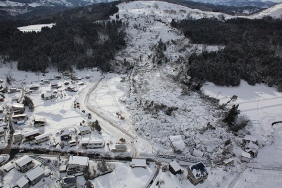
Landslide damage in Itakura-ku,
Joetsu City Photos showing
the status as of Mar.8th to 13th
from top to bottom (Source: Niigata Prefecture)
The landslide that started on Mar. 7th, 2012, in Joetsu City, Niigata Prefecture caused harm to people and houses. Like slope failure, debris flow, and other sediment disasters, landslides are often caused by heavy rainfall, such as long spells of rain in the rainy season or typhoons in summer. In Niigata Prefecture, however, about half of all landslide events that occur in one year are concentrated in the period from March to May. The frequent occurrence of landslides during this period is deeply linked to the fact that Niigata Prefecture is a heavy snowfall region.
A Landslide-Prone Region
Prefectural governments usually have lists and maps at landslide high-risk locations prepared and updated in advance. With 860 out of 11,288 locations all over the country, Niigata ranks third in the number of such locations, after Nagasaki Prefecture (1,169 locations) and Nagano Prefecture (1,241). The Joetsu area, where this landslide occurred, is one of the particularly landslide-prone areas in the prefecture. Such a phenomenon is deeply related to the local geological and meteorological conditions. The Joetsu area, located at the western end of the Fossa Magna, the great rift which geologically divides northern Japan and southwestern Japan, was born as a result of land which had been under the seabed until a few million years before being gradually thrust upwards. Through this tectonic movement, the layers of mud and sand deposited on the seabed were exposed to the air before they were fully petrified, and they inclined and became mountain slopes. When these layers contain a large volume of water, weaker layers separate from the bedrock, causing landslides to occur. This area receives a lot of snowfall, as indicated by the many ski slopes it contains. The accumulated snow gradually starts to thaw in March when the peak of heavy snowfall is over. Since snowmelt seeps into the ground incessantly until the snow disappears from the mountain surface, a large amount of water collects underground (as groundwater), like when there is a long spell of continuous rain. Those two characteristics ? "a geological feature likely to collapse as it contains water" and "a large volume of snowmelt that becomes groundwater" ? combine to make the Joetsu area one of Japan’s most landslide-prone areas.
(Source: Niigata Prefectural Government website)
(http://doboku-bousai.pref.niigata.jp/sabou/main.html?fnm=openMapDosya&no=17&no2=0)Japanese only
Legend of Human Sacrifice
The Itakura area (formerly known as Itakura Town before the merging of municipalities), where the landslide damage occurred, has a legend saying that a traveling Buddhist priest sacrificed himself to stop landslides. In later years, a large urn containing human bones was unearthed. Based on this finding and the results of human bone analysis, this has now been proven to be not just a legend but a real occurrence. Of course, we know now that human sacrifice cannot stop landslides. In ancient times, however, people had none of the civil engineering technology that we do today. This is one of the historical episodes that tells how humans have tried to fight landslides while still making great efforts to coexist with them.
(Source: Joetsu City website)
(http://www.city.joetsu.niigata.jp/soshiki/itakura-ku/itakura-ca-19.html)Japanese only
(Contact: Snow Avalanche and Landslide Research Center)