
Technology to Detect the Occurrence of Large-scale Sediment Transport

Fig. 1: Conceptual diagram of monitoring
the occurrence of large-scale
sediment transport
(click to enlarge)
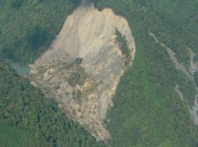
Photo: Landslide dam created
in the Misakubo area

Fig. 2: Results of epicenter
determination and analysis
(The basic map used is a 1:200,000
scale digital map from the
Geospatial Information Authority of Japan.
The data below is rainfall recorded
at the Konota Rainfall Observatory.)
(Click to enlarge)
Introduction
As mentioned in Web Magazine Vol. 26, the rainstorm associated with Typhoon Talas that hit Japan in September 2011 caused many deep-catastrophic landslides and created large landslide dams the Kii Peninsula. Since these landslide dams were occurred deep inside the mountains, it took a lot of time to find them. Once breached, a landslide dam can cause a large-scale debris flow, and this flow can flood communities far downriver from the landslide dam. Therefore it is important to detect landslide dams quickly and take appropriate countermeasures as soon as possible.
The Volcano and Debris Flow Research Team is working on technical development for monitoring such sediment transport phenomena.
Detection of Large-scale Sediment Transport Using Ground Vibration sensor
Once large-scale sediment transport occurs, the failed sediments hit the riverbank or riverbed. This impact causes a ground vibration which is then transmitted to a distant place. This kind of vibration is so small that we humans cannot feel it, but we can observe it using an highly sensitive sensor. It has already been proved that if this vibration can be observed with many sensors, we can estimate where and when a large-scale sediment transport phenomenon has occurred, just like we estimate the epicenter of an earthquake. In other words, developing a network of many highly sensitive sensors will allow us to monitor the occurrence of large-scale sediment transport (Fig. 1).
Application Example of Detection of the Location of Large-scale Sediment Transport (Photo and Fig. 2)
As mentioned earlier, Typhoon Talas brought heavy rainfall not only to the Kii Peninsula but also to the Chubu region. The Japanese Self-Defense Forces report found that a landslide dam had been formed in an area upstream of the Misakubo Storage Dam in Hamamatsu City, Shizuoka Prefecture, by Sep. 7th, 2011. Though we cannot know when the landslide dam was formed, data from the existing earthquake observation network recorded observation of vibrations not attributable to an earthquake at 18:07 on Sep. 4th, 2011. The aforementioned technique was then applied to this data, and the analysis results determined a location about 1 km away from the failure site.
Although a lot of caution is necessary in judging whether this vibration was caused by the landslide dam at Misakubo, we could have detected the occurrence of failure at Misakubo a few days earlier if this technique had been widely applied in practice.
Afterword
Unlike in flat areas, the mountainous areas where large-scale sediment transport mainly occurs do not have a fully established system of power and communication. Therefore, an observation network has not been satisfactorily developed. In order to achieve practical application and promotion of this technology, it is important to install many pieces of equipment that can measure vibration at a high sensitivity in mountainous areas. MLIT is installing vibration sensors at appropriate locations to establish the desired observation network system. PWRI provides the relevant technical support, including the publication of a manual on installing vibration sensors.
Hi-net, the National Research Institute for Earth Science and Disaster Prevention’s high-sensitivity earthquake observation network, was used in the aforementioned analysis of the detection data. The photos used here are provided by the Chubu Regional Development Bureau, MLIT. We acknowledge the cooperation of the relevant organizations for our research project.
(Contact: Volcano and Debris Flow Research Team)
Frost heave at roadside slopes in cold snowy regions
- ground elevation resulting from the presence of ice layers

Photo 1: Ice lenses formed
in an experiment
(click to enlarge)

Photo 2: Slope elevation caused
by frost heave
(click to enlarge)

Fig. 1: Frost heave and thawing of a slope
(click to enlarge)

Photo 3: Frost heave damage to a berm drain
on a cut slope The U-shaped trough
has tilted toward the mountain side due
to frost heave in the ground, and
will not return to its original position.
(click to enlarge)

Fig. 2: Mechanism behind berm
damage on a cut slope
(click to enlarge)
What is frost heave?
Frost heave is a phenomenon seen when soil freezes. Despite being inextricably linked to freezing, the meanings of the two terms are quite different.
Freezing: A phenomenon in which water contained in soil becomes solid due to low ground temperatures. Although the volume of water increases by approximately 9% upon freezing, when it freezes in soil, the increase in the volume of the soil itself is almost negligible.
Frost heave: As soil freezes from the surface downward, soil moisture moves toward the freezing isotherm and forms frozen layers known as ice lenses(Photo 1).Ice created in very shallow parts near the surface is known as needle ice. Ice lenses may form layers in soil, and their overall thickness is approximately the same as the frost heave amount(Photo 2).
Deep frost heave and significant locational fluctuations in its depth can cause road surfaces to crack. In severe cases, pavement damage or potholes may result.
What can be done to prevent frost heave on road slopes?
Although anti-frost heave measures have been established for road pavement surfaces, no preventive measures have been developed for frost heave damage to slopes. The occurrence of the phenomenon on slopes is problematic because slopes do not return to their original positions once elevation has occurred. Frost heave usually acts in the direction perpendicular to the slope surface, but the subsidence seen when ice melts follows the direction of gravitational force (Fig. 1). After several years of this cycle, the soil surface becomes loose and prone to collapse. As a result, protective structural elements and drains commonly installed on slopes may undergo deformation and even collapse in some cases. Photo 3 shows frost heave damage to a berm drain installed on a cut slope. Clarification of the mechanism behind this type of damage showed that berm drains are cooled not only from the slope surface but also from the inner wall of the drain; the resulting uneven forces acting on the drain cause it to tilt toward the mountain side (Fig. 2).
It is extremely difficult to predict the location and extent of such slope damage. In future work, further studies will be conducted with the aim of elucidating the frost heave phenomenon to support the proposal of rational frost heave countermeasures and methods of related diagnosis and risk assessment as part of efforts to control such damage.
(Contact: Geotechnical Research Team ,CERI)
A Study on Enhancing the Appeal of Roadside Rest Facilities
In response to growing demand for pleasant roadside rest areas in association with increased numbers of female drivers (up by a factor of around 1.6 between 1990 and 2010) and senior drivers (up by a factor of around 1.8 between 1990 and 2010), numerous Michi-no-Eki (roadside stations) have been authorized. Around 1,000 such facilities are now found throughout Japan, and are used by upward of 200 million people annually. In a related consideration, private/rental cars are now the mode of transport for approximately 75% of tourists in the country (rising to 80% for Hokkaido), and a rapid increase in the number of international visitors using rental cars has recently been seen in Hokkaido and other parts of the nation. Against this background, Michi-no-Eki have become infrastructural elements contributing to regional development not only as rest facilities but also as tourist information centers that enhance the appeal of driving-based tourism.
According to a Michi-no-Eki usage survey conducted by Japan’s Ministry of Land, Infrastructure, Transport and Tourism, 95% of Michi-no-Eki users stop at such facilities to take a break. However, the current situation is that the administrator that manages Michi-no-Eki overemphasizes product sales and food services and as a result pleasant relaxation areas are not provided sufficiently at Michi-no-Eki.
In this context, the Scenic Landscape Research Unit carries out studies to improve user satisfaction through enhanced appeal of Michi-no-Eki rest areas and to contribute to regional development with the goal of supporting the creation of favored tourist destinations.
The results of research conducted so far indicate that people involved in the running of Michi-no-Eki often fail to recognize that the appeal of rest areas is directly related to the management of these roadside stations, even though users actually favor pleasant rest areas at least as much as food services and shopping opportunities. As a result, insufficient consideration for the function of rest areas has resulted in low evaluation by users.
Research has further shown that people spend more time and money at Michi-no-Eki whose indoor and outdoor rest areas are highly rated (Fig. 1). This indicates that the provision of pleasant rest areas not only improves the user impression but also helps to revitalize roadside stations.
It is also known that appealing and unappealing rest areas each have particular characteristics, and that the relative positioning of outdoor elements such as parkland, trees, views, the design of viewing spots, signs, chairs, tables and shade greatly affect the appeal of such spaces. As seen in Fig. 2, the space between parking lots and buildings, the relative positions of parkland/rest areas and buildings, and the layout and location of parking lots significantly influence the user impression (Fig. 3). Some parkland and rest area layouts are known to be ineffective, as it is difficult for users to recognize or access them(Fig. 4).
Based on the results of this research, effective ways to improve Michi-no-Eki and increase their appeal will be examined.
 |
Fig. 1: Higher evaluations for outdoor rest areas equate to greater user expenditure(figures are average values for the 10 Michi-no-Eki surveyed) |
 |
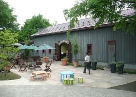 |
Fig. 2: Michi-no-Eki often have no outdoor rest areas(left) |
A private facility with a pleasant free rest area(right) |
 |
Fig. 3: Parkland in front of buildings has a positive influence on visitor ratings |
 |
Fig. 4: Parkland located in front of buildings is easily recognizable/accessible and was highly rated. However, such layouts are found at only around 10% of Michi-no-Eki. |
(Contact: Scenic Landscape Research Unit ,CERI)