
IFAS Ver.2 is available

Importing GIS data
(soil and geological data)
(click to enlarge)

Setting parameters according to
soil and geological features
(click to enlarge)
ICHARM has developed the Integrated Flood Analysis System (IFAS), which can perform flood-runoff analysis using satellite and ground observed rainfall data, and has made it available on its website. Using such satellite-based information, IFAS can perform flood analysis even in the case of basins for which ground observed data is lacking. ICHARM has held IFAS workshops in a number of developing countries, to encourage the use of IFAS.
In June 2014, ICHARM made the newest version of IFAS (IFAS Ver.2) available on our website.
IFAS Ver.2 incorporates significant improvements in ease of use, over the previous version, by changing the programming language. Reduction in operation time is a highly important factor for river administrators making real-time flood forecasting and decisions such as whether to issue an alert.
The number of GIS data types that can be imported into the system has also been increased, allowing soil and geological data to be entered, in addition to conventional altitude and land use data. With using these data, the standard parameters of the runoff analysis model can be set according to soil and geological features, increasing the efficiency of parameter setting.
The display function remains mostly unchanged from the previous version, but the model is not compatible with the previous version. Please note that runoff analysis cannot be performed with IFAS Ver.2 using simulation models created with the previous version.
ICHARM will continue to develop IFAS to improve its functionality, and would be grateful if you could try IFAS Ver.2 and give us feedback.
IFAS can be downloaded from http://www.icharm.pwri.go.jp/research/ifas/index.html.
(Contact: ICHARM (suimon@pwri.go.jp))
Viscoelasticity of asphalt- Hard or soft? Asphalt pavement exploiting the characteristics of asphalt

Figure 1 Crushed stone (left)
and asphalt binder (right)
(click to enlarge)

Figure 2 Change in the shape of
asphalt due to surface inclination
(click to enlarge)

Figure 3 Conception of required
warm mix asphalt performance
(click to enlarge)
Roughly 90% of the roads in Japan are paved with an asphalt mixture consisting of crushed stone and asphalt binder mixed at an appropriate ratio (Figure 1). Asphalt is an oil-based polymeric material which serves as a binder in such mixtures, due to its strong binding force. Although asphalt is typically thought of as a solid, it melts at high temperatures and hardens at room temperature. Exploiting these characteristics, asphalt is mixed at high temperatures with crushed stone in plants, and the resulting asphalt mixture is laid on roads while maintained at a temperature where it remains soft. As it cools, the mixture hardens and forms a durable surface for vehicular traffic.
Thus, such asphalt mixtures are commonly used for road surfacing. However, ruts and cracks develop in asphalt pavement over time due to vehicular use, and specifically due to the viscoelasticity of asphalt, which results in gradual deformation when the asphalt surface is subjected to loads for an extended period of time (Figure 2). The viscoelasticity of asphalt also influences the ease of production and application of the asphalt mixture. By studying the viscoelasticity of asphalt using various methods, the Advanced Materials Research Team develops asphalt quality evaluation in terms of specific performance needs.
In recent years, a technique (warm mix asphalt technique) has been developed to reduce the temperature required for the production and construction of asphalt pavement, and thereby reduces the CO₂ emissions involved in these processes. The technique thus contributes to reduction in CO₂ emissions and mitigation of global warming. The asphalt pavement production temperature is reduced by about 30℃ through the addition of a special additive (warm mix asphalt additive), to produce a warm asphalt mixture. It is necessary, in this process, for the production and construction temperature of the resulting warm mix asphalt mixture to decrease, and for the mixture to harden, in the same manner as conventional asphalt, in the service temperature range (Figure 3). To achieve this, the Advanced Materials Research Team seeks to standardize the quality of warm mix asphalt by studying its viscoelasticity. We also conduct research on warm mix asphalt quality improvement, as well as viscoelasticity-based performance evaluation.
(Contact: the Advanced Materials Research Team)
Study on the Evaluation of Sequential Landscapes Viewed from the Road, and the Optimization of Road Space
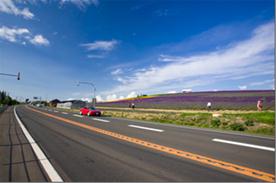
Photo 1 Roadscapes are
local resources
(a section used for the experiment)

Photo 2 How roadscapes are
evaluated by the pressing of a button
(click to enlarge)

Photo 3 Sections evaluated
favorably by many subjects (above)
and few subjects (below)
(The numbers here correspond
to those in Figure 1)
(click to enlarge)
1.Significance of Landscapes Viewed from the Road, and Their Evaluation
Attractive roadscapes are important local tourist resources, contributing to regional development. In light of this, regional development measures are undertaken by harnessing roadscapes, such as in the Scenic Byway Hokkaido and Scenic Byway Japan initiatives.
To promote such beautiful roadscapes, it is essential to ensure that roads allow for safe, pleasant driving, while keeping road spaces free from any hindrances.
This raises the question: What are roadscapes that people regard as pleasant or unpleasant? To answer the question, it is necessary to understand the factors and elements that influence one's impression.
Analyzing what influences people's impressions of roadscapes will be effective for determining the sites that require landscape-sensitive development and for considering methods for improving roadscapes.
2.Driving Test on a National Highway
To answer the questions about what roadscapes impress or don't impress people, we conducted a driving survey. The test road was a road section approximately 10 km long between Biei and Kamifurano, Hokkaido (Photo 1). The test was intended to evaluate the sequential landscape in both directions. Subjects were asked to make a round trip in a car and to press and hold an evaluation button when they found the view from the car to be pleasant (Photo 2). They were also asked to describe what they felt while looking at the view, with their responses being video recorded.
3.Results and Discussion
In Figure 1, the longitudinal axis shows the number of subjects who evaluated the view as pleasant, and the vertical axis shows the travel distance. From the figure, it is cleared that the factors and elements that allow the subjects to appreciate the landscape have some features in common: favorable evaluations of the view concentrate in a few specific sections, and the favorable evaluations increase sharply at the beginning of each section.
However, the favorable evaluations do not last long. In Section A (No.6: roadside trees continue uniformly), the favorable evaluations gradually decrease after sharply peaking. This may be because an unchanging sequence made the subjects feel that the roadscape was too familiar and unstimulating.

Figure 1 Number of driving test subjects who pressed the button to indicate a favorable evaluation of the view, and the driving sections
(click to enlarge)
An analysis of the sections that earned the most favorable and least favorable evaluations reveals the following common features.
(1)Favorably evaluated sections are those with the following.
·The view includes rural landscapes such as paddy fields, as well as mountain ranges in the middle or far distance, but has no physical obstacles.
·Roadside trees (e.g., snowbreak forests) continue such as to give the subject an idea of the road geometry.
·The view changes from a roadscape enclosed by buildings to an open landscape with distant panoramas.
(2) Unfavorably evaluated sections are those with the following.
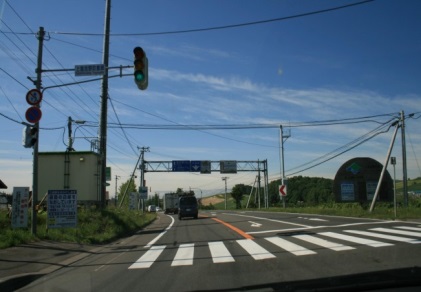
Photo 4 Road accessory structures
that affect the viewer's impression
·There are natural middle-distance and distant views, but there are also nearby signboards, electric poles and wires, and other road accessories.
·Artificial structures with eye-catching colors, such as warning signs and drum-shaped buffering facilities, are easily visible.
·The view changes from open landscapes with surrounding farmland to closed landscapes with deep forests.
·The road changes from straightaways to curves.
·The roadscape changes from that of various views from slopes to that of views from flat roads that lack variety.
4.Toward Future Studies
Based on the results of this roadscape evaluation and our analysis of its factors and elements, we will propose methods for selecting sections for landscaping, and for developing measures that will be designed to combine landscaping with maintenance of appropriate road functionality.
(Contact : Scenic Landscape Research Unit, Civil Engineering Research Institute for Cold Region)