
An Efficient Measurement Technology for Effective Road Width in Winter by Using a 2D Laser Scanner
and the effective road width
1. Purpose of development
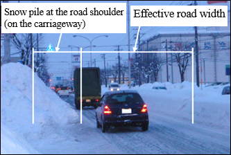
The effective road width decreases in winter because of growing snow piles at the road shoulder, and the reduced road width is a factor that affects winter road traffic by causing traffic congestion (i.e., reduction in travel speed) (Photo-1). By clarifying the relationship between the effective road width and the travel speed, it becomes possible to effectively maintain and manage efficient winter road traffic. Securing the necessary road width is possible by conducting snow hauling before traffic congestion occurs. However, inspection for the effective road width in winter has been mainly done visually by road patrol personnel. Nearly no quantitative inspection has been done. To facilitate efficient maintenance and management of winter roads, we have developed a technology for efficiently and safely measuring the effective road width.
2. Overview of the measurement system
The measurement technology was developed to enable quantitative measurements by considering the economy, efficiency, and safety of measurement. For the measurement equipment, a 2D laser scanner was employed, because it is relatively inexpensive and the structure of the system is simple. The distances of objects are able to be measured only by the emission of laser beams. The shapes of the road surface and snow piles in the transverse direction of the road are continuously measured by a laser scanner mounted on a vehicle (Figure-1). The measurement locations, time and travel speed data are obtained by using a GPS sensor, and photos showing the state of the road being measured are shot by using a USB camera. The measurements are done from a traveling vehicle; therefore, it contributes to the safety of the measurement personnel who need not to work on busy carriageways.
The effective road width is automatically calculated by specialized software using the analyzed road transverse profile. The software determines the boundaries between the road surface and snow piles and road structures (Figure-2).
 |
 |
3. Road measurement experiment
The performance of this technology was tested by conducting an experiment on a national highway in Sapporo City. The road selected for this experiment has urban, suburban, and mountainous districts along it. The test vehicle traveled at an ordinary speed on this highway and tested the developed technology. In this experiment, it was found that there was no considerable data dispersion, and the analysis results of the laser data on the transverse road profile (snow piles, sidewalk, etc.) agreed well with the images taken by the USB camera. It was verified that measurement using this technology can be done on an actual road and from a vehicle traveling at an ordinary speed. We also found that measurement by using this technology was sufficiently accurate. The maximum measurement error was 35mm (i.e., the result of the test done on the premises of the institute).
(Contact:Machinery Technology Research Team, CERI)
2018 Hokkaido Eastern Iburi Earthquake
2018 Hokkaido Eastern Iburi Earthquake
An earthquake with an epicenter in the central-eastern Iburi region of Hokkaido occurred at 3:07 AM on September 6, 2018. Seismic intensities of 7 were observed in Atsuma Town near the epicenter. Seismic intensities of 6+ were observed in Abira Town and Mukawa Town near Atsuma. In Sapporo, seismic intensities of 6- were observed in Higashi Ward. According to the Fire and Disaster Management Agency, 42 died and 762 were injured in this earthquake, which was named by the Japan Meteorological Agency as the 2018 Hokkaido Eastern Iburi Earthquake. All of Hokkaido was left without electrical power supply. This blackout continued for a few days. This disaster remains fresh in our minds.
Immediately after this earthquake, the Geotechnical Research Team launched onsite surveys on geotechnical hazards, and the results are introduced in this document. In cooperation with the National Institute of Land and Infrastructure Management and Tsukuba Central Research Institute, we conducted investigations and provided technical instructions at the request of the Hokkaido Regional Development Bureau and the City of Sapporo. For details, please read the Special Issue for the Eastern Iburi Earthquake of the Monthly Report of the Civil Engineering Research Institute for Cold Region (March 2019)
https://thesis.ceri.go.jp/db/documents/public_geppo_month/2019/3/
in the Satozuka District
Liquefaction damage in Sapporo City
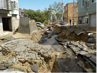
In this earthquake, many houses in the Toyohira and Kiyota wards of Sapporo, which is about 50 km from the epicenter, tilted or subsided. In the Kita and Higashi wards, streets cracked and caved in. The Geotechnical Research Team started surveys on the day of the earthquake and responded to requests from the City of Sapporo. Photo 1 shows a damaged street and houses in the Satozuka District of Kiyota Ward where large-scale damage to houses occurred. A residential area in the Satozuka District had been developed on land that had been used for paddy fields. This area is at the narrow bottom of a valley, and had been filled using volcanic ash cut from the surrounding hilly areas. The survey revealed that the filled part of the land liquefied from earthquake motion. Such liquefaction is rare. In ordinary liquefaction, subsurface liquefied soil blasts out at the surface of the liquefied location. However at Satozuka, the liquefied soil moved horizontally along the slope of the original ground and blasted out at locations where the filled soil layers were thin.
Slope disaster in Abira Town
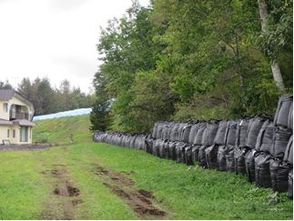
In response to requests for assistance made by the Town Office of Abira through the Hokkaido Regional Development Bureau, the Geotechnical Research Team, together with the Geological Hazards Research Team, conducted surveys on the damage to the ground in residential areas, at natural slopes, and in filled areas of Abira Town. The two teams also provided technical advice on emergency restoration of the area. The areas surrounding Abira Town are hilly land covered with volcanic ash. Our survey revealed that the filled areas and natural slopes in such areas had surface failures. Some houses were near the failed slopes; we advised that emergency measures were necessary, and we advised that houses be protected by covering cracks on the slope with blue tarps and by placing large sandbags as emergency standby retaining structures (Photo 2).
(Contact:Geotechnical Research Team, CERI)