River Disasters Caused by Ice Jams and Mitigation Measures
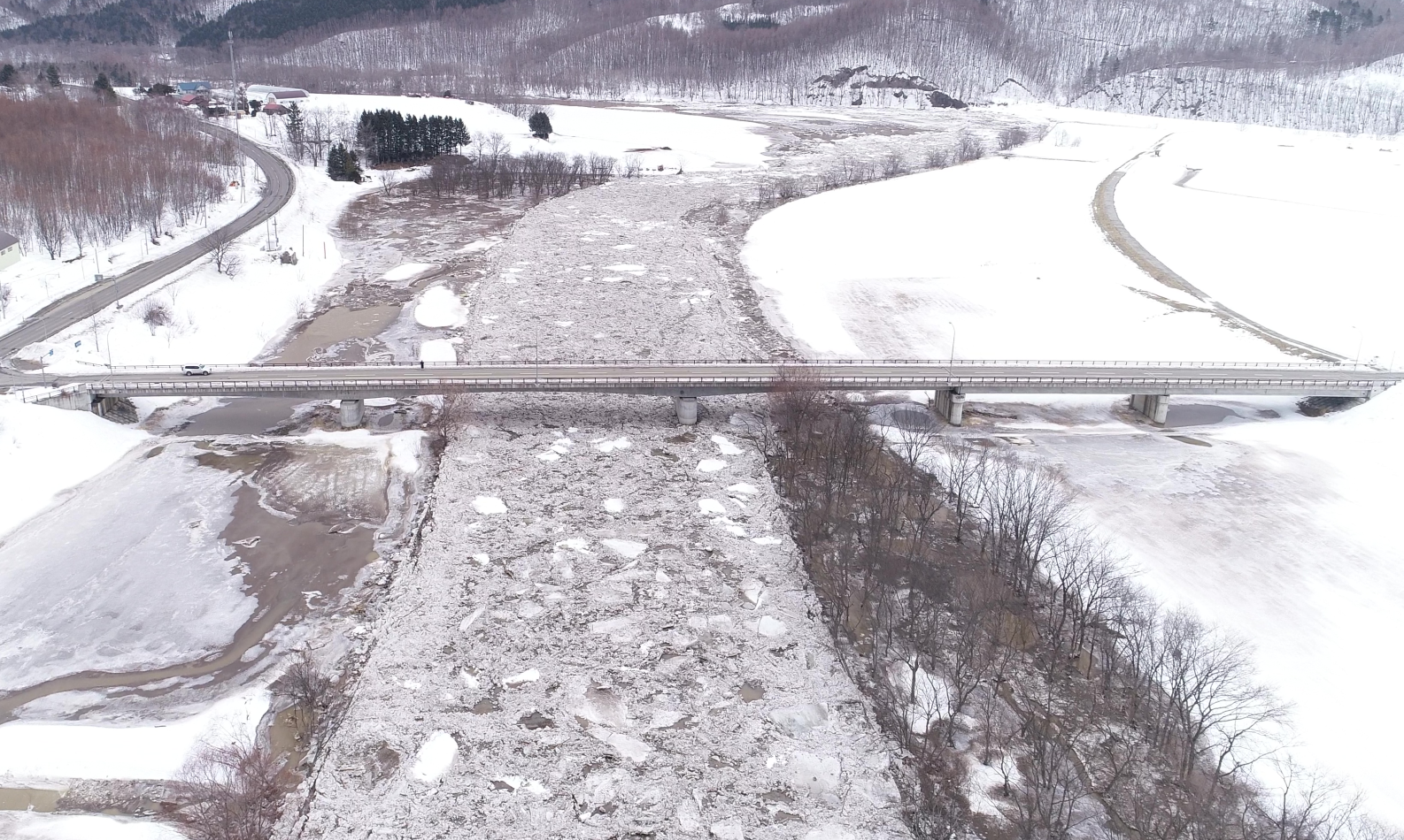
Rivers in cold regions freeze during the mid-winter and thaw in the spring as temperatures rise. The thawed ice flows downstream and sometimes causes an "ice jam," meaning that the blocks of ice clump together to block the river. In March 2018, ice jams were observed simultaneously in many rivers in Hokkaido, which resulted in water level rise, flooding, and personal injury and vehicles damage in ice jams.
To study the mechanism of formation of these ice jams, the Civil Engineering Research Institute for Cold Region (CERI) conducted a joint field survey with the Kitami Institute of Technology in the areas where the ice jams were observed. The findings revealed that the ice jams were simultaneously formed in the following process:
(1) From the day before to the day of the ice jams, a temperate depression passed through Hokkaido while developing, resulting in a sudden rise in temperature and unseasonal rainfall, which caused the thawing of the ice and flood across a wide area simultaneously.
(2) As a result, the thawed river ice flowed down rapidly and accumulated in the slow flowing parts of the rivers, causing the ice jams.
 | 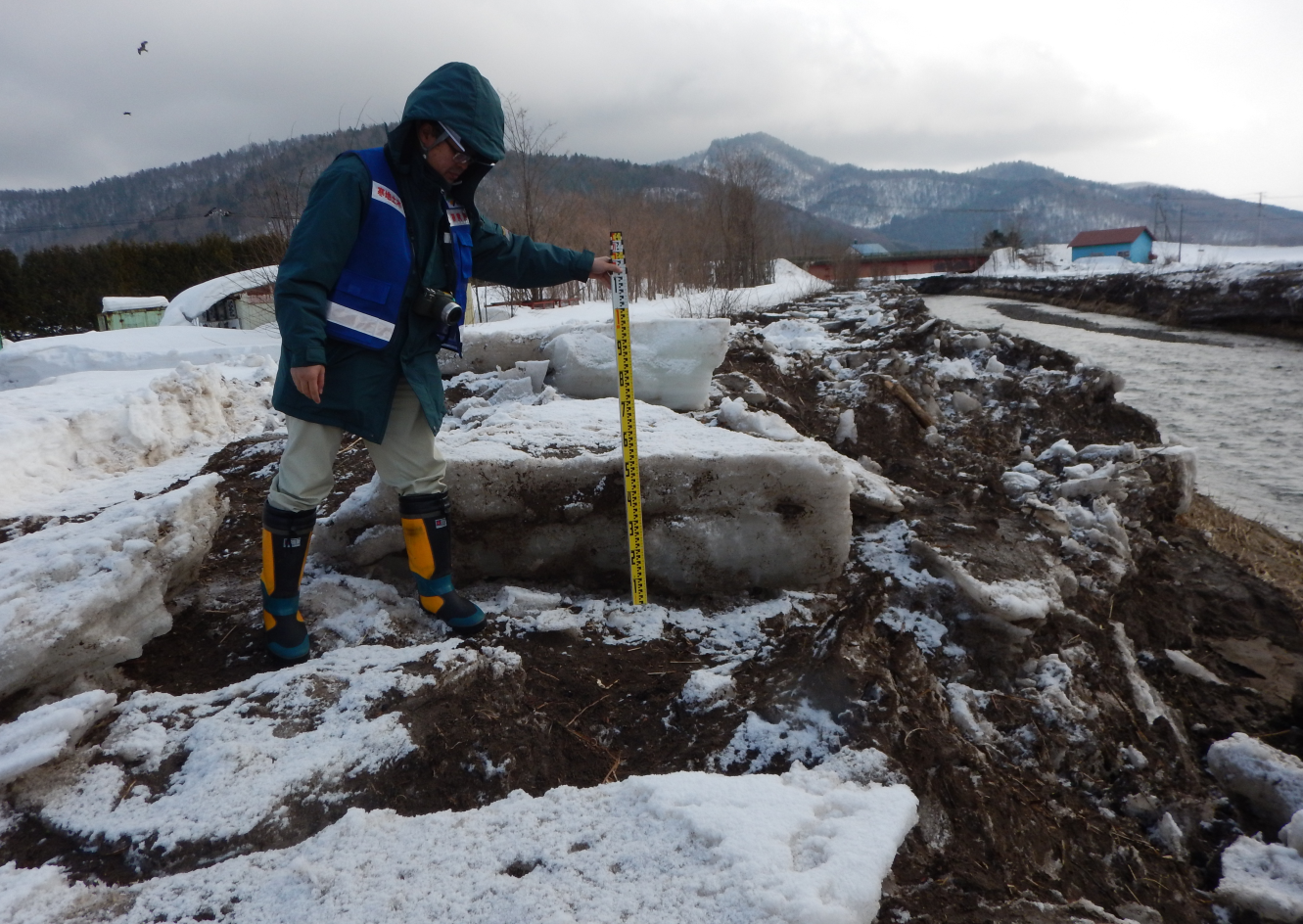 | ❋Source: Hokkaido Regional Development Bureau |
To mitigate and reduce damage from river disasters caused by ice jams, it is useful to have a technique for predicting periods and areas with a high risk of ice jams. As part of the joint study with Kitami Institute of Technology, CERI is developing a practical method for predicting the occurrence of ice jams.
For the prediction of periods, we are developing a program that can calculate and forecast time series of river ice thickness at any point in a river using meteorological and river level data. The program runs on a personal computer and uses meteorological and river level data publicly available online. We are verifying the accuracy of ice thickness predictions and the timing of occurrence of ice jams against data on actual ice jams that occurred in rivers in Hokkaido. We also intend to conduct pilot projects at river control facilities and construction sites during the winter in order to promote the practical use of the program for the purpose of river management and disaster prevention.
 | 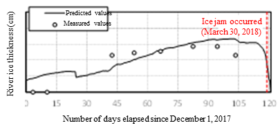 | (Uryu River) |
(Contact: River Engineering Research Team, CERI)
A Study on the Frequency of Avalanches due to Short-Term Heavy Snowfall
Introduction
In implementing avalanche countermeasures, it is important to assess the magnitude and frequency of avalanches in a given area and determine the need for countermeasures by referring to the past avalanche disaster records and conducting surveys on snow cover, topography and vegetation in that area. However, since long-term observations of avalanches have only been conducted in areas where a massive avalanche occurred in the past, it is often difficult to directly assess the frequency of avalanches in other areas. In this study, we examined a method for estimating the frequency of avalanches by identifying past snowfall events with conditions that cause avalanches due to short-term heavy snowfall, using meteorological data. For more information, please refer to the article titled "Frequency Analysis of Snowfall Events Associated with Avalanche Release Conditions" in the CERI Monthly Report (May 2019).
Methods
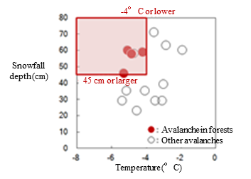
For the analysis of frequency of avalanches based on meteorological data, we focused on the conditions that cause avalanches during short-term heavy snowfall as shown in Fig.1. Fig.1 shows the relationship between air temperature and snowfall amount during the 12-hour period when the snowfall was the most intense. As shown by ● in Fig.1, during short-term heavy snowfall, avalanches can occur also in forest areas where avalanches are normally unlikely to occur. The avalanche release conditions in such a situation include a 12-hour snowfall amount of at least 45 cm and an average air temperature of -4℃ or lower during the snowfall period (Condition 1). Depending on the slope and other factors, a snowfall mount of at least 50 cm may become a requirement. In addition, the presence of a certain amount of snow cover (snow depth of at least 50 cm (Condition 2)) is also important for avalanches to occur. Therefore, we calculated 12-hour snowfall amounts based on past meteorological data and extracted snowfall events that met Conditions 1 and 2.
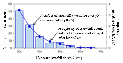
Next, the numbers of extracted snowfall events were counted at intervals of 5 cm of snowfall amount (the bar graph in Fig. 2). Then, , the cumulative numbers of snowfall events from classes of larger snowfall amounts at intervals of 5 cm were calculated and divided by the number of years of observation (the line graph in Fig. 2). The obtained value means the frequency of snowfall events with a 12-hour snowfall amount of at least S cm (shown on the horizontal axis in Fig.2) (number of events per year).
Results
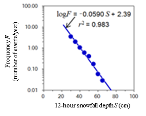
Fig. 3 shows an example of the results of analysis of the logarithmic relationship between 12-hour snowfall amount and the frequency of occurrence of snowfall events. By taking the logarithm of the frequency, its relationship with snowfall amount can be expressed as a straight line. The equation obtained in the analysis shown in the figure corresponds very well to the observed values. Therefore, this equation can be used to accurately estimate the frequency of occurrence of snowfall events with a 12-hour snowfall amount of at least 45 cm or at least 50 cm (i.e., snowfall events associated with the avalanche release conditions in Fig. 1).
Use of Results
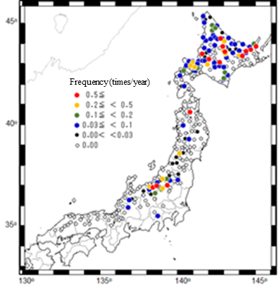
The same analysis was performed concerning 297 locations (the Japan Meteorological Agency´s AMeDAS stations and the Hokkaido Regional Development Bureau´s telemeters) to determine the distribution of frequency of avalanches in forests due to short-term heavy snowfall (avalanche hazard map) (Fig. 4). This study has made it possible to evaluate the risk of avalanches in forests, which were previously considered to be unlikely to occur.
 |
(Contact:Snow and Ice Research Team, CERI)

