
[Flash Report on Field Survey] Landslide Occurred in Harunocho, Tenryu Ward, Hamamatsu City, Shizuoka Prefecture

Photo 1 Condition of the landslide site
(click to enlarge)

Photo 2 Crack in the green tea field
(click to enlarge)
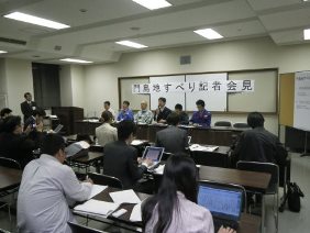
Photo 3 Chief researcher (a person
who has a microphone) from
Landslide Research Team answering
questions at a press conference
A slope failed in the Kadoshima area, Harunocho-sugi, Tenryu Ward, Hamamatsu City, Shizuoka Pref., at around 4:20 in the morning of Apr. 23rd, 2013, and the debris flowed down the slope and into the Sugi River (Photo 1). The Landslide Research Team of the Erosion and Sediment Control Research Group conducted a field survey on Apr. 23rd, 2013, at the request of the Shizuoka prefectural government.
The failed slope had a gradient of about 50 degrees. The size of the landslide, as of the date of the survey, measured about 80m in width, about 90m in length, and about 20 m in depth, with the amount of collapsed debris estimated to be about 50,000㎥. The deposited debris dammed part of the river channel, but the river water continued to flow. Cracks were first found on the green tea field atop the slope on Mar. 22nd. The prefectural government began observation of the expansion condition of the cracking on Mar. 25th, and remained on alert thereafter. As the continuing observation discovered an increasing amount of displacement, Hamamatsu city government issued an evacuation advisory on Apr. 21st; and as a result, 24 citizens from a total of six households were evacuated to a nearby public hall.
The geology of the failed slope is mudstone belonging to the Shimanto Belt. Highly crushed materials were also observed in this area. It is thus considered highly likely that this area is significantly weathered as a whole. Open cracks on the green tea field atop the slope are distributed continuously, (Photo 2), and it was deemed likely that the slope failure would extend farther up the slope.
The Landslide Research Team provided local government with technical advice on the prospects of slope failure expansion and related emergency response measures. We are committed to providing technical assistance to them on an ongoing basis.
(Contact: Landslide Research Team)
Senior Researcher Takahiro Sayama, of ICHARM, Awarded the Young Scientists' Prize of Commendation for Science and Technology by the Minister of Education, Culture, Sports, Science and Technology
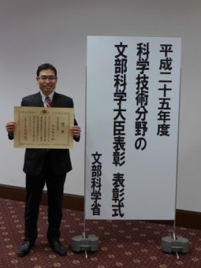
Dr. Takahiro Sayama (photo left), Senior researcher for the Water-related Hazard Research Group, ICHARM, has been awarded the 2013 Young Scientists’ Prize of Commendation for Science and Technology by the Minister of Education, Culture, Sports, Science and Technology (MEXT). The award ceremony was held in a lecture hall on the 3rd floor of MEXT, on April 16th, 2013.
MEXT regularly acknowledges outstanding achievements in R&D, or the promotion of understanding about science and technology, by awarding prizes of Commendation for Science and Technology. Among these awards, the Young Scientists’ Prize is presented to researchers under 40 years of age who have generated remarkable results involving excellent R&D capability, such as epoch-making discoveries or unique research from an original or innovative viewpoint.
Dr. Takahiro Sayama has been awarded the 2013 prize for his "Research on Rainfall-Runoff-Inundation Prediction for Major Floods Worldwide." His specific achievement lies in the development of "the Rainfall-Runoff-Inundation Model (RRI Model)," an integrated technique for predicting a wide range of phenomena affecting entire river basins, including river flow rate and inundation, designed to apply to major flood events occurring throughout the world. Until now, rainfall-runoff phenomena affecting mountainous areas, and inundation phenomena affecting flat areas, were simulated using different models, making it very difficult to swiftly and accurately analyze complex events involving both these phenomena. However, the technique developed by him is designed to analyze a wide range of phenomena affecting an entire river basin, from rainfall and runoff to flood and inundation; and to make swift and reliable predictions concerning inundation, with the input rainfall data obtained on a quasi-real-time basis for the entire extent of the river basin.
An example of its application is shown in this figure, depicting a flood event that occurred in Thailand in 2011. The flood simulation was conducted at an early stage, and the model predicted that the flood conditions would persist in the downriver region for an extended period of time (about a month) thereafter. The results were presented in an animated format, for better understanding of the actual flood conditions (see http://www.icharm.pwri.go.jp/news/news_e/111024_thai_flood_e.html); and various media outlets, including NHK, used the results, in this format, for their news reports on the flood.
A series of such studies were esteemed for their contribution both to social action and to the development of science and technology; and the technique is expected to be further refined, increasing its value in reducing flood disaster risks throughout the world.

Fig. Rainfall-runoff-inundation model (RRI model) applied to a flood event in Thailand
(left: Observed result; right: simulation results)
(click to enlarge)
(Contact: Planning and Management Division)
Observation of the Natural dam on the Way Ela River, Ambon Island, Republic of Indonesia, with Aerial Placeable Floating water stage gauge

Fig.1 Location of Ambon
(click to enlarge)

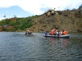
Photo 1 Landslide dam
and the downriver community
(click to enlarge)
In Japan, deep-seated landslides occurred in the Kii Mountains, caused by heavy rain associated with Typhoon No.12 (Talas), in Sep. 2011. Fifteen natural dams were created. The Aerial Placeable Floating water stage gauge (hereafter, APF gauge) developed by Public Works Research Institute (hereafter, PWRI) was installed from helicopters at four sites by the Kinki Regional Development Bureau, MLIT (hereafter, KRDB). The observation data disclosed to the public on the KRDB website was of great use in raising local residents' awareness of the danger of natural dam failure. Those experience has improved the knowledge and technique of countermeasures against natural dam.
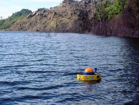
A deep-seated landslide occurred on the valley-wall of the Way Ela River, Ambon Island, Maluku Province, Republic of Indonesia, in July 2012 (Fig. 1). A collapsed sediment formed a large river blockade (natural dam) as high as about 170m. About 5,000 residents nearly lived downstream of the natural dam. If the event of a breach of the dam occurred, severe damage caused by sediment and water flow would be assumed. It was necessary to establish warning and evacuation system based on water-stage observation (Photo 1).
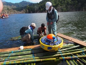
With the collaboration of the Indonesian government, PWRI installed the APF gauge on Feb. 28th , 2013, for the first time outside Japan. Although the APF gauge is possible to be dropped from helicopters, in the case of the Indonesian natural dam a vehicular road was used to transport the APF gauge to the waterfront of the natural dam reservoir. A human-powered boat and bamboo raft were used to install the APF gauge on the water reservoir, even if conventional water stage gauges had already installed by the Indonesian government before 28th Feb. (Photos 2,3 and 4).
The APF gauge is a device composed of a submerged cage fitted with a hydraulic pressure sensor that measures the water depth and a floating buoy fitted with satellite communication equipment that sends the data (Photo 5). The satellite communication equipment of the APF gauge is less vulnerable to sinking, damage, or washout due to floating on the water surface. Thus the APF gause has the better characteristics than conventional water gauges, because the APF gauge is able to be installed far from collapsed valley-wall and natural dam. If installation of a gauge is near a natural dam, the gauge is possible to be damaged because of the re-collapse of valley-wall and natural dam. In addition, as the APF gauge uses satellite communication, it allows for near real-time observation of the water level of a natural dam in a foreign country, and rapid transmission of the observation data to all relevant organizations.
The installed APF gauge allowed PWRI and the Ministry of Public Works, Indonesia, to monitor the risk of water overflow or breaching of the natural dam on a near real-time basis. This monitoring supported the establishment of the natural dam warning and evacuation system for this country.
This undertaking aims to support the reinforcement of Indonesia's monitoring and observation capability, establishment of a better warning and evacuation system, and improvement of the country's risk management capability against natural dam disaster. In addition, we are able to collect the information to improve the functionality of the APF gauge based on an application to the various situation in foreign countries.
 |
 |
|---|
Photo 2 (click to enlarge) Photo 3
 |
 |
|---|
Photo 4 Photo 5
(Contact: Volcano and Debris Flow Research Team)
CAESAR Activities Reported by NHK's Tokuho Shutoken!
Program crew covering the story
Local government staff visiting the facility
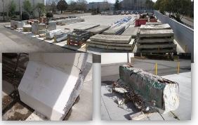
Demolished bridge section storage,
and bridge sections used in the program
NHK's documentary program, Tokuho Shutoken (“Special Report for the Metropolitan Area”), which aired on Friday, Apr. 19th, 2013, with the feature “Can Crisis be Avoided! - The Looming Infrastructure Crisis,” described the activities of CAESAR.
Over the past four years, Tokuho Shutoken has repeatedly focused on aging infrastructure, with titles like “Expressways, The Looming Crisis”, “Shrinking Japan - What Should be Remain and What Should be Relinquished”, “Shrinking Japan - How can a private enterprise take the public works!”, “Shrinking Japan - Restoration through Utilization of Private Initiative”, and “Why! No Water Stored in Dam Reservoirs.”
Focusing on inspection of infrastructure, the latest feature dealt with aging infrastructure, an issue that has emerged as a clear and present danger for all Japanese since the ceiling plate of Sasago Tunnel Collapse.
CAESAR was introduced in the program as one of the organizations engaged in research on diagnosis and maintenance of aging bridges, and in provision of advice to local governments.
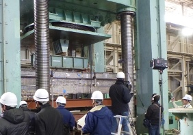
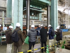
CAESAR collects sections of demolished bridges and conducts research on the use of these sections, as part of its investigative research on the utilization of existing and demolished bridges in Japan.
The program showed a loading test involving the section of a demolished bridge, conducted last Jan.The demolished bridge was provided by a local government. On the day of filming, the staff of the local government that donated the bridge to CAESAR visited the lab, saw the loading test, and visited other laboratories, with great interest.
The program also explained the importance of early detection of aging signs by means of inspection and observation, to prevent infrastructure deterioration, while showing an actual deteriorated bridge in a PWRI storage facility for demolished bridge sections.
The program audience sent many comments and opinions to NHK's website concerning the program; and this reminds us yet again of people's keen interest in the problem of aging infrastructure.(http://www.nhk.or.jp/tokuho/program/130419.html)(in Japanese)
CAESAR intends to continue to provide the general public with research results and the latest information on infrastructure maintenance, and to support people on the front line to prevent accidents involving aging infrastructure.
(Contact: CAESAR)
Follow-up Seminar in Bangladesh
Seminar
Awarding of seminar certificate
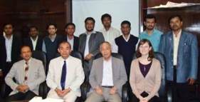
ex-participants and ICHARM staff
ICHARM and the Bangladesh Water Development Board (BWDB) jointly held a follow-up seminar on sediment hydraulics and river management, in Dhaka on Feb. 13th and 14th, 2013. The general purpose of the seminar is to provide follow-up assistance to the ex-participants of JICA/ICHARM training course, to enhance the personal network between them and ICHARM, and to provide them with an opportunity to obtain the latest knowledge and information. The seminar is held annually, in different countries, together with respective local organizations. Those at the Bangladesh seminar included 22 participants from Bangladesh (11 of whom were ex-participants) and 4 from ICHARM: Minoru Kamoto, Chief Researcher; Kelly Kibler, Research Specialist; Muhammad Masood, Research Assistant (also ex-participant); and Shinji Egashira, Adjunct Professor of the National Graduate Institute for Policy Studies.
The seminar focused on the sediment rundown process, its related river morphology, and river management, as major themes in light of the current river conditions in Bangladesh. On the first day of the seminar, staff from ICHARM and BWDB, as well as from local research institutes including the Center for Environmental and Geographic Information Services (GEGIS), the Institute of Water Modeling (IWM), Bangladesh University of Engineering and Technology (BUET), and Dhaka University of Engineering and Technology (DUET), gave guest speaker lectures. The lectures typically focused on the characteristics unique to the rivers in Bangladesh, and problems related to their management. In particular, conventional techniques based on river engineering often do not help us cope with problems arising in differing river environments. Thus, Bangladeshi river managers are searching for new solutions to river-related problems including riverbank erosion, flooding, and channel capacity retention. The lectures emphasized that such innovative solutions are particularly needed for the Jamuna River.
On the second day, a discussion session involving ex-participants was held; and all participants shared their experiences of JICA/ICHARM training course and explained how they took advantage of this experience in their current work. Ex-participants evaluated highly the JICA/ICHARM training course, and demonstrated how they utilized the techniques acquired there in their current job. They also exchanged notes on unconventional ways of applying the knowledge they had obtained in Japan.
ICHARM intends to conduct follow-up activities for ex-participants, and to enhance and reinforce this initiative through the maintenance and enhancement of the personal network between ICHARM and the ex-participants.
(Contact: ICHARM)
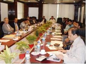
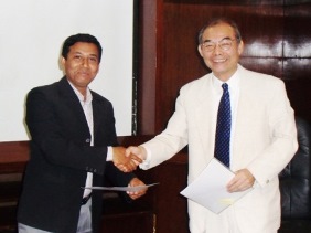
Final Report of ADB's Technical Assistance Project Submitted
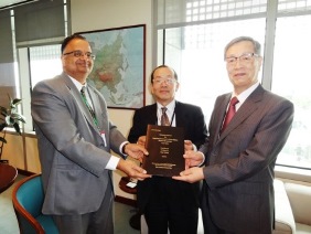
Final report submitted
(Left to right: Regional and
Sustainable Development Department
Director General Chander,
Chief Executive Uomoto,
and Director Takeuchi)
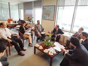
Opinions exchanged among members
On Mar. 12th, 2013, ICHARM submitted a final report to the Asian Development Bank (ADB) on the technical assistance project, “Capacity Development Technical Assistance for Supporting Investments in Water-Related Disaster Management (TA7276-REG)” conducted jointly with the bank since Nov. 2009, to mark the successful completion of this project.
The project was the first of its kind for PWRI, as it involved the joint implementation of a project by PWRI and a foreign organization, based on a partnership agreement, using funds obtained from an external source. Intended for countries and regions prone to frequent flooding, such as Indonesia, Bangladesh, and the Lower Mekong Basin countries, the project conducted various activities aimed at improving response capability to flood disasters. The activities included improvement of a disaster management system through practical training on IFAS (the Integrated Flood Analysis System developed by ICHARM) and evacuation training in the Solo River basin in Indonesia, and implementation of flood vulnerability evaluation based on satellite information and GIS (a geographical information system) in Cambodia.
The submission ceremony for the final report was held at the ADB headquarters in Manila, Philippines. PWRI Chief Executive Taketo Uomoto , ICHARM Director Kuniyoshi Takeuchi, Chief Researcher Toshio Okazumi (TA7276 team leader), Research Specialist Mamoru Miyamoto, and assistant Taeko Akimoto participated in the ceremony.
At the meeting, Chief Executive Uomoto expressed gratitude for the opportunity to implement this project. Director Takeuchi noted with pleasure that ICHARM had learned a great deal through the process, and that the experience will be utilized in future projects and activities. The Director General of the Regional and Sustainable Development Department, Seethapathy Chander, said he was very grateful for the significant achievements of ICHARM. The Director of the Sustainable Infrastructure Division, Gil-Hong Kim, thanked ICHARM for the successful establishment of excellent networks and relationships among ADB's Developing Member Countries. Amy S.P. Leung, Director of the Urban Development and Water Division of the Southeast Asia Department, requested ICHARM's further contribution to urban flood risk management, based on the experience of the project. It was the mutual intention of all present to further enhance the cooperative relationship between ADB and ICHARM. In closing, Chief Executive Uomoto noted the importance of exploiting such activities as foundations upon which to accumulate further knowledge and experience; and Director Takeuchi emphasized that the most important thing in risk management is to reduce flood disaster risks before disasters occur, by clarifying vulnerabilities in advance, and noted that ICHARM will continue to focus on this effort.
(Contact: ICHARM)
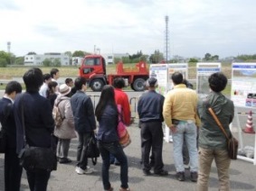
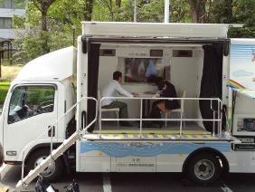
Record Number of Visitors Enjoy the Open House during Science & Technology Week
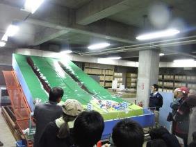
Sediment disaster simulated using
the debris flow generator
A wide range of research on
pavement explained
Seismic Intensity Level 7 motion
experienced in the earthquake
simulation vehicle
PWRI held a joint Open House with the National Institute for Land and Infrastructure Management (NILIM) on Friday, Apr. 19th, 2013, in concert with Science & Technology Week, celebrated annually in the middle of April. Enjoying good weather, the Open House welcomed 282 visitors, a record number. Below are the major programs that were open to the public.
●Bus tour to experiment facilities
This year's bus tour consisted of three courses : River and Sediment Disasters, Pavement and High-speed Experience, and Tsunami and Maintenance. At each course, tour participants visited the respective experiment facilities. Among these, two were unusually popular according to the visitor questionnaire.
The first facility housed the debris flow generator, renovated last March. This machine is designed to simulate the impact of debris flow on a downstream area in the event of a sediment disaster, given the presence or absence of a sediment control dam. When simulated sediments flowed down from the upstream section of the model, visitors were keenly interested in what would ensue, and followed with fascination the explanation of the research staff.
At the pavement test field, the staff discussed a variety of topics relating to road pavement, ranging from basic research to cutting-edge studies. Visitors showed their approval of an unmanned loading vehicle designed to advance pavement durability research, described by the staff.
As in past years, the high-speed bus experience on the test field was much enjoyed by visitors; and participants in all courses of the tour seemed highly satisfied with the experience.
●Earthquake simulation vehicle
Just as last year, we received the cooperation of the Tsukuba Municipal Central Fire Department to operate its earthquake simulation vehicle, allowing visitors to experience various levels of earthquake motion, including that of the Great East Japan Earthquake. This event served as a compelling reminder to visitors of the critical importance of daily disaster prevention awareness and preparedness. Feedback from visitors who experienced the seismic motions included “Terrifying” and “Good opportunity”.
It seemed that this was the first time for many of the visitors to the Open House. PWRI hopes to make as many people as possible aware of our research and activities, now that there is steadily increasing interest among the general public in civil engineering in general, including response measures to aging infrastructure and large-scale disasters.
We listen carefully to the comments and opinions of visitors, and incorporate them into our future Open House planning. Our entire staff is committed to providing to the general public the most valuable Open House events possible.
(Contact: General Affairs Division)