
Malaysia´s Works Minister Zin Visited PWRI
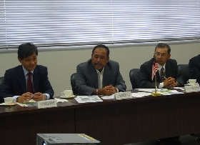 Scene of Questions&Answers |
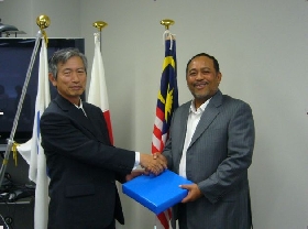 Chief Executive Sakamoto (left) And Minister Zin(right) |
On June 9, 2008, a group of 16 Malaysian visitors including Malaysia´s
Works Minister Zin and Malaysian Ambassador Extraordinary and Plenipotentiary
to Japan visited PWRI and held discussions with PWRI staff. Malaysia is
a country with a land area of some 330,000 km2, about 0.9 times that of
Japan, and a population of 26.64 million. Malaysia is a prosperous country
whose main industries include manufacturing (electronic appliances), agriculture
and forestry (natural rubber, palm oil and lumber) and mining (tin, crude
oil, and LNG).
The origin of this visit was Malaysia´s plan to establish a research institute related to civil engineering techniques, and the Embassy of Malaysia in Japan announced the wish of Malaysia´s Works Minister Zin to visit PWRI to acquire the necessary knowledge. PWRI accepted the request and the result was this visit.
During the discussion, an active questions and answers session was conducted on various themes including the relationship between PWRI and the Japanese government, personnel exchanges, the selection of research themes, and research funding. PWRI staff were informed that Malaysia has an interest in research in a variety of fields related to civil engineering including the environment, traffic issues, ITS, and structures, and wanted the proposed research institute to conduct wide research related to public works.
The Malaysians requested Japanese cooperation with the establishment of their research institute, and PWRI told them they would offer the necessary cooperation including the provision of information.
At the end of the visit, Minister Zin and Chief Executive Sakamoto shook hands warmly thus signalling the warm conclusion to a friendly exchange of opinions.
(Contact: Planning and Management Division)
PWRI Attended the UNESCO-IHP Intergovernmental Council
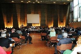 The Council (Meeting room at UNESCO headquarters) |
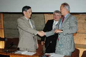 Rector of UNESCO-IHE, the Netherlands, Meganck shaking hands with ICHARM Director Takeuchi after signing the Memorandum of Understanding. Behind them is UNESCO Director of Water Science Division, Szollosi-Nagy. |
The 18th Intergovernmental Council of UNESCO´s International Hydrological
Programme (UNESCO-IHP) was held from June 9 to 13, 2008, at the UNESCO
Headquarters. Thirty-six council member countries including Japan participated
in the meeting along with 41 non-council members and 23 international organizations.
The participants from the International Centre for Water Hazard and Risk
Management (ICHARM) were Kuniyoshi Takeuchi, the ICHARM Director and also
a member of the Japan National Committee for UNESCO, and Akira Terakawa,
ICHARM Deputy Director, who attended the Council as members of the Japanese
delegation.
IHP is a framework that pursues various programmes including scientific research on water circulation, research and proposals related to the sustainable management of water, and the promotion of human resources development in developing countries through cooperation of the governments of the participating nations. The Water Science Division of UNESCO serves as the secretariat of IHP (IHP website: http://typo38.unesco.org/index.php?id=240). The Intergovernmental Council is held biennially for the purposes of passing on information and holding discussions on the activities of IHP, IHP future policies, and arranging coordination and cooperation with other international and non-governmental organizations.
One of the important topics discussed at the Council meeting was the Plan for the 7th Phase for the period 2008 to 2013. Approval was obtained for action under five main headings: (1) Adapting to the changes on river basins and aquifer systems; (2) Strengthening water governance for sustainability; (3) Ecohydrology for sustainability; (4) Life-supporting water management; and (5) Water education for sustainable development. UNESCO water-related centre, which includes ICHARM, is to play a core role in executing the Plan.
Seven nations, Turkey, Brazil, Kazakhstan, Dominica, the USA, Germany and Portugal proposed the establishment of a new UNESCO water-related centre, and it was determined that the preparatory procedures would begin with the support of other participating nations in order to obtain approval at the UNESCO Assembly. In particular, it is hoped that the International Center for Integrated Water Resources Management proposed by the US government (planned for establishment at the Institute for Water Resources, US Army Corps of Engineers) and the International Center for Water Resources and Global Changes proposed by the German government (planned for establishment at the Hydrological Research Institute, Federal Republic of Germany) will be jointly promoted because these institutes are closely related to water disaster risk management, which is the concern of ICHARM. the Institute for Water Resources, the US Army Corps of Engineers and ICHARM had a comprehensive cooperation agreement in June 2006.
During the lunch break on the first day, a ceremony was held in which a comprehensive agreement on cooperation was signed by ICHARM, the Institute for Water Education (IHE), Delft, the Netherlands, and the Regional Centre on Urban Water Management (RCUWM), Tehran, Iran, in front of the participating nations. Various activities will be planned and conducted under the agreement, including the mutual dispatch of training lecturers and the planning and implementation of joint research.
(Contact: ICHARM)
Integrated Exhibition of the Environment 2008 in celebration of the Hokkaido Toyako Summit (Part 1) – Flood Forecasting Systems developed by ICHARM –
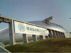 Sapporo Dome |
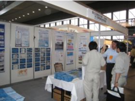 ICHARM´s exhibition booth with MLIT and IDI |
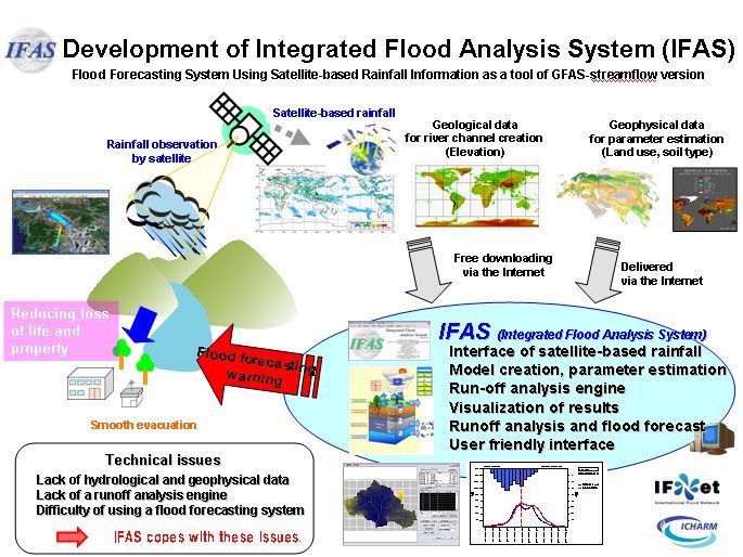 Conceptual image of IFAS |
The Integrated Exhibition of the Environment 2008 in Celebration of the Hokkaido Toyako Summit was held at the Sapporo Dome in Sapporo City, Hokkaido, from June 19 to 21, 2008. The exhibition site was filled with a showcase of environment-related efforts, including advanced techniques and technological products. Fun events also welcomed visitors and offered them interesting opportunities to have various types of hands-on experience. The International Centre for Water Hazard and Risk Management (ICHARM) of the Public Works Research Institute (PWRI) set up a joint exhibition with the River Bureau of the Ministry of Land, Infrastructure, Transport and Tourism (MLIT) and the International Development Institute (IDI) to publicize ICHARM´s research activities.
In recent years, the number of water-related disasters has been increasing, and the world, especially developing countries, has been suffered from grave human losses. Asia alone accounts for 83% of the disaster victims worldwide. It is also projected that the scale and frequency of violent storms will become greater due to climate change and sea level rise caused by global warming, which is likely to increase the risk of water-related disasters. Under these circumstances, it is important to promote safe, quick evacuation in case of disaster especially in regions and countries where river works has not been sufficiently developed. To realize such evacuation, effective measures should be implemented. Hazard maps should be provided for residents to inform them of risks they may face in case of disaster. Flood forecasting and warning systems should be installed to help people make appropriate decisions on whether evacuation is necessary. In reality, however, not much progress has been made in installing such systems due to financial constraints or lack of rainfall data.
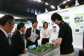
At the ICHARM exhibition booth, we prepared posters and pamphlets to outline a wide variety of activities in which ICHARM is currently involved, including research, development, and training to help prevent water-related disasters across the world. In particular, the ICHARM hydrological Engineering Research Team demonstrated two flood-related systems; the Global Flood Alert system (GFAS-Rainfall) using satellite-based rainfall data and the Integrated Flood Analysis System (GFAS-Stream flow, IFAS) to assist developing countries in reducing flood damage. IFAS is designed to automatically produce a runoff analysis model based on elevation, land use, rainfall and other kinds of data. The system is considered to be effective especially in poorly gauged or ungauged areas, because it allows the users to conduct runoff simulation necessary for flood forecasting and warning using satellite-based rainfall data.
The Integrated Exhibition of the Environment attracted over 80,000 visitors during the three-day period, and turned out to be a great outreach opportunity for ICHARM.
(Contact: Hydrological Engineering Research Team, ICHARM)
Integrated Exhibition of the Environment 2008 in Celebration of the Hokkaido Toyako Summit (Part 2) – River Environment, Aquatic Resources, and Biomass
 A meandering river model on display |
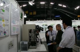 A biogass indoor fermentation-testing device on display 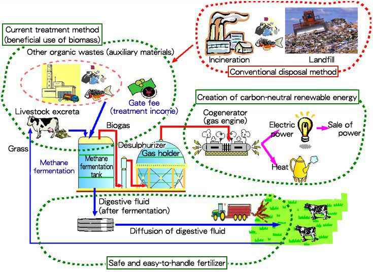 Cyclic use of biogass at Bekkai Biomass Plant |
With the global environment as its theme, the Integrated Exhibition of the Environment focused on the latest efforts and activities related to environmental issues undertaken by 333 corporations, administrative organs and research institutes both inside and outside Hokkaido. The Exhibit Zone was divided into four categories: (1) Environmental Education and Eco Life, (2) Biomass and New Energy and Energy Saving, (3) Environmental Technology and Consulting, and (4) Waste Treatment and Disposal and Recycling, and introduced advanced environmental techniques, products and services including those tackling global warming.
The Civil Engineering Research Institute for Cold Region (CERI) participated
in the Exhibition in cooperation with the Hokkaido Development Bureau,
MLIT, in line with the concept of "environmental initiative,"and
the initiative was taken by the four CERI teams actively engaged in environmental
issues, namely the River Engineering Research Team, the Watershed Environmental
Conservation Research Unit, the Fisheries Engineering Research Team, and
the Rural Resources Conservation Research Team.
The River Engineering Team and the Watershed Environmental Conservation
Research Unit exhibited models and panels on the theme of the "development
of techniques to create and maintain a river environment that is rich in
biodiversity by restoring meandering rivers."The meandering river
model that shows "how to restore the naturral environment of rivers"was
very popular, and the researchers were kept busy explaining their work
to the many visitors who came to see the model.
The Fisheries Engineering Team exhibited models of blocks that serve as
a nursery for spawning spear squid and panels based on the theme of "improving
the function of aquatic life habitats in the waters in cold region ports
and the development of water environment preservation techniques."
The Rural Resources Conservation Research Team exhibited indoor fermentation
testing equipment and panels on the theme of the "development of techniques
for turning biomass into fertilizers and energy and the clarification of
efficient transport techniques."Since biomass is a hot issue that
is currently attracting a lot of attention, many visitors asked such questions
as "What is a ´biomass plant´?"or "What is this machine
for?"This made us realize how strong an interest the general public
has in biomass.
(Contact: Planning Division)
Tsukuba Juvenile Doctor – Experiencing High-speed Travel and Demonstration of Construction Robot
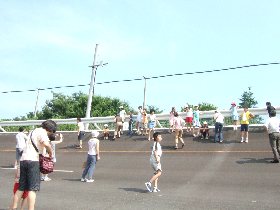 Children experiencing the bank slope |
 Gravity and centrifugal force shown by the red arrows are balanced 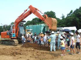 Visitors enjoying a closer look at the construction robot and its excavation results |
The annual event, Tsukuba Juvenile Doctor, was jointly held by Tsukuba City and the National Institute for Land and Infrastructure Management (NILIM) on July 25, 2008. Here is a brief outline of the event.
Six trips provided by a tour bus service brought a record total of 348 visitors including both adults and children (296 last year) to the event venue. The bus entered the test roadway in front of the main NILIM building and headed for the south loop while passing a red unmanned loading vehicle parked in the pavement driving test area.
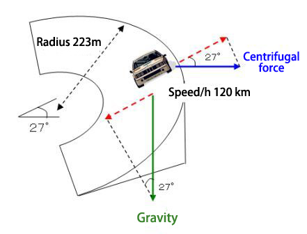
Children climbed the steep slope of the bank at the south loop. Although the slope seemed to be of no major interest to the adults, it turned into a really enjoyable place for the children who went up and down the slope repeatedly. The slope has a gradient of 27˚ and a radius of 223 m. When a car enters this sloped curve at a speed of 120 km, the centrifugal force and the gravitational force are balanced. When the visitors in the bus experienced this phenomenon as the bus drove on the slope at that speed, they all cheered loudly.
The visitors then went to the Consutraction machine test field and watched demonstrations of the hydraulic excavator of a construction robot. The visitors listened intently to the explanation of the Advanced Technology Team staff.
The robot, already mentioned in the PWRI News in Web Magazine No. 4, is a next-generation machine under development of the current remote-controlled construction machine that played a major part in restoration work after the Iwate-Miyagi Nairiku Earthquake. To automate digging and the loading work of the hydraulicexcavator as construction of a basic technology of the IT-construction system with the robot construction machinery,
it researches. A prototype of this IT-based construction system has been produced, and a verification experiment is under way.
Excavation with a hydraulic excavator is a difficult job even for human operators unless they are experts. Children watched a demonstration of a robot carefully excavating the ground as programmed by checking its operational status, witnessed the excavation result, and had a close look at the shovel.
The children, although slightly exhausted by the heat of the day, which
was over 30˚C, expressed such feelings as "I think we should encourage
the production of robots like this."or "It´s great that the robot
was moving automatically by itself."This demonstration of the robot
hydraulic excavator and its explanation were covered by NHK(Japan Broadcasting
Corporation) and aired on ´Shutoken-Network´, a news program for digital
terrestrial broadcasting provided by the Mito Broadcasting Station of NHK.
(Contact: General Affairs Division)
Former PWRI Researcher Dr.Samhee LEE Awarded The Civil Merit Medal
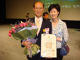 The award winner Dr. Samhee LEE and his wife Mrs. Mikyung KIM |
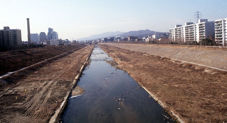 Before restoration 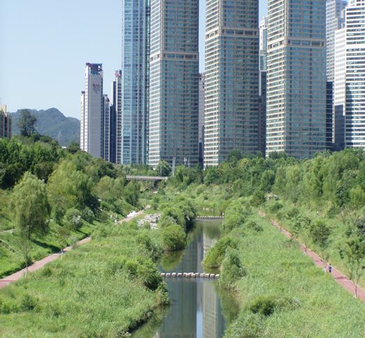 After restoration |
One of the former PWRI special researchers, currently a supervising researcher at the Korea Institute of Construction Technology, Dr. Samhee LEE, 47, was awarded the Civil Merit Medal on June 5, 2008 by Korean President LEE Myung-bak for many of his achievements as a Korean pioneer of river restoration. The medal is a prestigious award stipulated by the Korean Constitution, and the award to Dr. LEE means the honor was given to a river engineer. He applied the theory of natural river restoration and the practical techniques he learned at PWRI to South Korea for the first time, and successfully proved their effectiveness. Those achievements are highly valued; hence this award.
Dr. LEE formulated a restoration plan for the Yanje River as a trailblazing
program for South Korea´s urban river restoration in 1995, and continued
to lead this field by providing planning and research support for many
subsequent river restoration projects. The features of the restored rivers
he planned are a better landscape and a greater variety and size of fish
compared with the past straight channels of conventional urban rivers.
His achievement had a great impact on South Korea´s river administration
and helped greatly in increasing the people´s awareness of the river environment.
He is the authority, in deed as well as in name, as regards South Korea´s
"nature-friendly river engineering,"which is equivalent to the
Japanese concept of river restoration or the creation of rivers with multiple
natural features. The famous restoration of the Chonge River in Seoul was
realized following the trend set by Dr. LEE, who also played an important
role in the planning stage of that restoration project. And these achievements
resulted in this award.
There is a close relationship between Dr. LEE and PWRI, including today´s NILIM. He stayed in Japan as a JICA participant in 1992 and learned a lot about how to create a river with many natural features at PWRI. In 1995, to continue his study of the river environment techniques of Japan, he revisited Japan through the Cooperative Graduate School System with Tsukuba University. He conducted research on the river environment of the Tama River at the River Divisionand the River Environment Division of PWRI and acquired a doctor´s degree in 1999. He said, "The techniques and concepts I learned in Japan led me to this award. I really appreciate PWRI and the Japanese people."
(Contact: General Affairs Division)
Action Taken after the Iwate-Miyagi Nairiku Earthquake in 2008
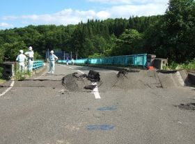 Field inspection of road damage |
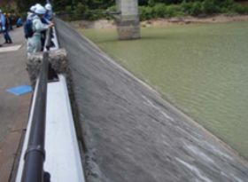 Safety check at the Ishibuchi Dam 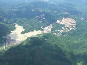 Landslide damage at Aratozawa, Kurihara City, Miyagi Prefecture |
A large earthquake with a magnitude of 7.2 at its epicenter occurred on June 14, 2008. A wide area in Iwate-Miyagi Prefectures, mainly Oshu City and Kurihara City, experienced a maximum seismic intensity of 6 plus. The earthquake caused a lot of serious damage including damage to roads and bridges, landslide and landslide dam. At the request of MLIT and local governments, PWRI immediately sent staff to provide technical support i.e. field investigation of the damage and restoration work.
(1) Road
A total of 34 members of PWRI were dispatched between June 15 and 25 to investigate road-related facilities. The onsite inspection covered the Matsurube-Ohashi of national highway Route 342, road embankments and side slopes along Routes 342 and 397, the Izawa Tunnel on Route 397, the Shin Tamayama Tunnel on prefectural road No. 42, and seismic faults around prefectural road No. 49.
(2) Dam
Dam inspection were undertaken by a total of five PWRI staff dispatched on June 15, 16, and 28, 2008. They inspected the Ishibuchi, Minase, Kamiohsawa, Koda, and Aratozawa Dams, and provided technical support to help the local authorities to judge dam safety and consider disaster countermeasures.
(3) Sabo (corrosion control)
Over 60 PWRI staff members were sent to the sabo field between June 15 and July 16 to make urgent checks of dangerous spots for sediment-related disasters , support rescue workers looking for missing people, and provide technical guidance and support for the monitoring of many landslide dam.
(Contact: Planning and Management Division)
Research Evaluation Conducted by PWRI in FY2008
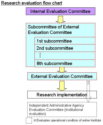 Research evaluation flow chart |
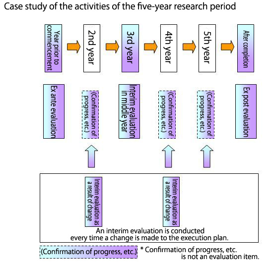 Case study of the activities of the five-year research period |
 Members of the External Evaluation Committee during discussion |
PWRI must conduct its research activities efficiently and effectively and feed the research results back to society. To this end, it is imperative to put in place a highly transparent evaluation mechanism and incorporate the research results positively into future R&D activities. Currently PWRI evaluates the R&D activities and results at the pre-research, interim and post-research stages with respect to the need for R&D, implementation, progress, quality of outcome, status of incorporation, research system, etc. based on the principle that every independent administrative agency should perform the task for which it is responsible.
There are two types of evaluation: internal evaluation by PWRI and external evaluation by scholars with a high degree of specialty such as university or private researchers. The evaluation results are examined and discussed first by the Internal Evaluation Committee, then by the subcommittees of the External Evaluation Committee and finally by the External Evaluation Committee. The Internal Evaluation Committee holds meetings twice a year, while the External Evaluation Committee and its subcommittees are convened annually. This year the Internal Evaluation Committee was held for a total of six days from April to May, the subcommittees of the External Evaluation Committee for a total of 8 days from April to May, and the external Evaluation Committee on June 24, 2008.
Since FY 2008 is the middle year of the five-year mid-term plan, we conducted an interim evaluation of our research activities. We also performed an interim evaluation related to the changes in the research, a pre-research evaluation and a post-research evaluation.
The External Evaluation Committee session discussed and examined the evaluation
results of its subcommittees. Evaluation Committee members expressed a
wide range of opinions and comments about the direction of research, the
utilization of research results, and personnel development. To end the
session, the Chairman of the PWRI Evaluation Committee, Prof. Takeshi Tamura
of Kyoto University, commented, "The research is being conducted smoothly,
and it is hoped that the results of the evaluation discussions of the Committee
and each subcommittee will be taken into consideration when pursuing this
research. As a whole, the activities of PWRI have shown a great improvement."
(Contact: Evaluation and Coordination Section)
Open House for CERI
 Demonstration of the liquefaction model experiment Meandering river model (popular every year) |
 (Left) Rumble strip experience (Right) Soil water draining and retention experiment 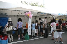 Highly popular quiz rally 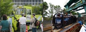 Cold Region Machine Technology Team Seismic motion experiment |
The annual Open House event of the Civil Engineering Research Institute
for Cold Region was held on July 4 and 5, 2008. Based on the theme "Let´s
Look at the Wisdom of the Northern People as regards Protecting their Livings,"14
research teams and one unit made their own unique presentations to enlighten
some 1,600 visitors during the Open House.
«Experience and Demonstration Program»
Every participating team offered experience and demonstration programs
as in previous years and attracted many visitors as participants in the
programs. The "liquefaction model"shook a model made of soil
and reproduced the way in which soil liquefaction occurs in the event of
an earthquake. The "meandering river model"answered the simple
question of why an originally meandering river had to be straightened.
In the "rumble strips"experience section, participants boarded
a passenger vehicle and actually felt the effectiveness of the "rumble
strips,"which are now being promoted as a preventive measure against
frontal collision. At the hands-on section called "Let´s Check How
Soil Drains or Retains Water,"visitors learned what soil is appropriate
for farming as they saw water poured into one plastic bottle filled with
clay and another filled with sand.
In addition, there were many other experience and demonstration programs and they won praise from the visitors.
«Quiz Rally»
14 research teams and one unit prepared quizzes related to research and
organized a quiz rally. Although some of the quizzes were difficult, hints
were hidden in the teams´open facilities and in display panels. Nearly
500 visitors gave correct answers to all the quizzes. The successful participants
were awarded the certification of ´Docter of Civil Engineering for Cold
Region´.
«Others»
Other features included an exhibition of snow removing machines and observation vehicles, demonstrations using PCs, display panels, and video presentations designed to help deepen the visitors´understanding of research activities.
We had many groups of guests from primary schools, junior highs, and kindergartens, in addition to groups from civil engineering high schools and technical schools, also many people in the neighborhood. They came to know more about our institute.
(Contact: Planning Division, CERI)