
Improving the Durability of National Highways Pavement: Development of High-performance SMA

Rough pavement surface created by coarse aggregate.
[Portion underlying the surface]
Highly dense, stable and durable.


high-performance SMA
1. Development of a pavement surface mixture for national highways in cold, snowy regions
Porous asphalt pavement has been used for national highways administered by the Hokkaido Regional Development Bureau, in consideration of safety at high travel speeds. But the surface of porous asphalt pavement has been damaged at a number of places in many road sections that have been in service for many years. This has resulted in problems, such as poor trafficability and an increase of cost for repairing the damaged surface.
To solve these problems, the Road Maintenance Research Team of the Civil Engineering Research Institute for Cold Region developed high-performance stone mastic asphalt (SMA), a durable pavement material that ensures safety at high travel speeds on national highways.
Figure 1 shows a cross-section of a high-performance SMA pavement. The coarse aggregate gives the pavement a roughness that resembles that of porous asphalt pavement. The portion underlying the surface is very dense because voids in the aggregate are filled with pulverized limestone and asphalt mortar. High-performance SMA is a mixture that has high durability and the ability to maintain safe driving conditions (Photo 1).
2. A guide to high-performance SMA (draft), and a test construction using high-performance SMA
A guide to high-performance SMA ("Guide (draft)") was created for the purpose of increasing the use of high-performance SMA. The Guide (draft) contains the following information: points to bear in mind in designing mix proportions, the necessary test items, construction techniques for securing the required mean profile depths (MPD) on the pavement surface, and technical standard values of MPD. The Guide (draft) is downloadable from the website of the Civil Engineering Research Institute for Cold Region. Downloads exceeded 1,800 as of the end of September 2016.
High-performance SMA was used in the test construction of a highway (Photo 2). In the three years after the construction, the standard value of MPD, 0.9 mm or higher, was maintained and no aggregate scattering has been observed. Satisfactory road surface conditions have been secured.
In the future, the Road Maintenance Research Team will continue to check the surface conditions at test construction sites in its efforts to realize the long-term durability of pavement.
(Contact: Road Maintenance Research Team, Civil Engineering Research Institute for Cold Region)
Study of the sediment transport at a river mouth on the basis of high-frequency topographic survey (Further report of Vol. 36)
Sediment supplied from a river to the ocean is transported to the nearshore region by wave action, resulting in the formation of sand-covered shoreline. Therefore, to estimate the shoreline variation, it is crucial to clarify the rate of the sediment supplied from the river to the ocean and its transport rate by wave action. High-frequency topographic survey at the river mouth is the most effective measure to evaluate the rate of sediment from the river and its transport rate by wave action. However, common public survey at a river mouth has been conducted one or two times in a year at most. In such a low frequency survey, it is very difficult to accurately evaluate the rate of sediment supply and transport at the river mouth because the sediment is significantly transported in a short time due to the wave action and outflow from the river.
We conducted a high-frequency topographic survey at the mouth of the Mu River in northern Japan, one or two times in a month from April 2013 to September 2014, and clarified the sediment transport process quantitatively.

Figure 1. Topographic variation based on the first survey
(red: accretion, blue: erosion, arrow: center of the river mouth)
The east of the river mouth was found to be eroded because the westward longshore sediment transport is almost blocked by jetty and revetment. The sediments in the east area was transported along the neareshore region (water depth: 0 m-5 m) to the west of the river mouth, developing the sandbar from the east to the west due to the westward wave action. The total erosion volume in the east area was about 25.0*104 m3, and the total accretion volume in the west area was about 25.0*104 m3 (Figure 1).
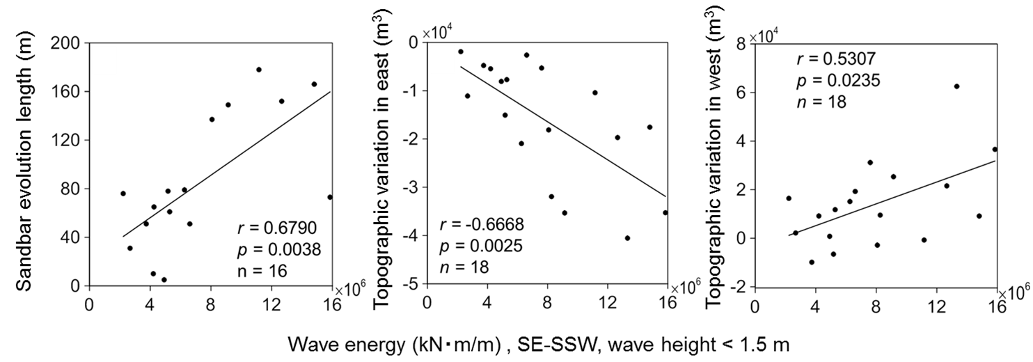
Figure 2 Relationship between wave energy and (a) sandbar evolution length,
(b) topographic variation in the east area, (c) in the west area
(wave direction: SE-SSW, wave height: lower than 1.5 m)
From the relationship between the wave energy and topographic variations in two consecutive surveys (Figure 2), it was found that wave action especially with the height lower than 1.5 m from SE-SSW, which was swell condition observed from June to September, significantly affected the sediment transport from the east to the west.
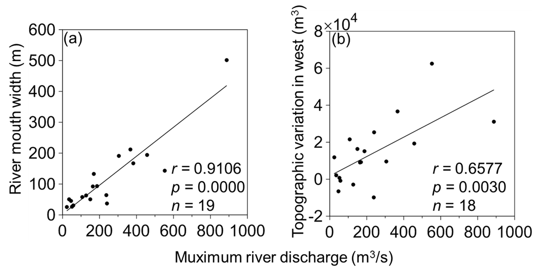
Figure 3 Relationship between the maximum discharge and (a) river mouth width,
(b) topographic variation in the west area
From the relationship between the maximum river discharge and topographic variations in two consecutive surveys (Figure 3), it was also found that the width of the river mouth and the accretion volume in the west area increase with increases of the river discharge.
In this study, we could not clarify the rate of the sediment supply from the river to the ocean. We are going to try it in the future study by conducting river and ocean surveys simultaneously with a high accurate survey system.
(Contact: Port and Coastal Research Team, Civil Engineering Research Institute for Cold Region)