
Fish that use Gaps between Rocks: Clarifying the Relationship between Gaps and Fish Habitats

Spaces that are formed by gaps between rocks are somehow thought to be good for the environment because they are used as places where fish and other aquatic life live. In fact, many different kinds of environment-friendly embankments that have spaces built into them have been developed.
Nonetheless, in only a few cases have the functions of such gap environments
been evaluated. Because gaps rank with plants as elements of waterside
environments, it is important to ascertain their functions as habitats
in the same manner as plants (for information on plant functions, please
see “ARRC NEWS No.6” of the Aqua Restoration Research Center(ARRC)). ARRC has conducted numerous
surveys on gaps using experimental streams. These tests have noted that
the types of fish that use gaps differ depending on rock size and shape,
and have clarified differences between spaces and plants as habitats.
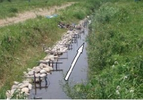
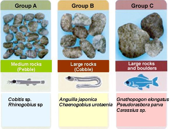
First, looking at the relationship between substrates and fish, there is
an apparent trend whereby smaller substrates attract greater numbers of
small demersal fish, and larger substrates bring more swimming fish. Field
gudgeons, stone morokos, and crucian carps tend to live in areas with boulders,
while Japanese eels, gobies, and other medium to large demersal fish live
where cobbles are present. Moreover, it has been confirmed that the number
of fish in rock-gap habitats reaches double that of waterside plant habitats,
and that they serve as winter habitats-a function that plants do not have.
Although this study is ongoing, ARRC plans to clarify environmental functions
from the riverbank to the water´s edge (including the ecological functions
of gaps), and to compile the results based on their relationships with
embankment construction methods during the current fiscal year. ARRC opens
its experimental tests to technical personnel and explains the roles of
environmental elements in gaps and other features at various times. Please
visit ARRC´s website for a schedule and other information.
(Contact: Aqua Restoration Research Center)
Creating Hydrogen Energy from Biogas
 Questions enthusiastically posed to foreign researchers |
 Participants and commemorative photography |
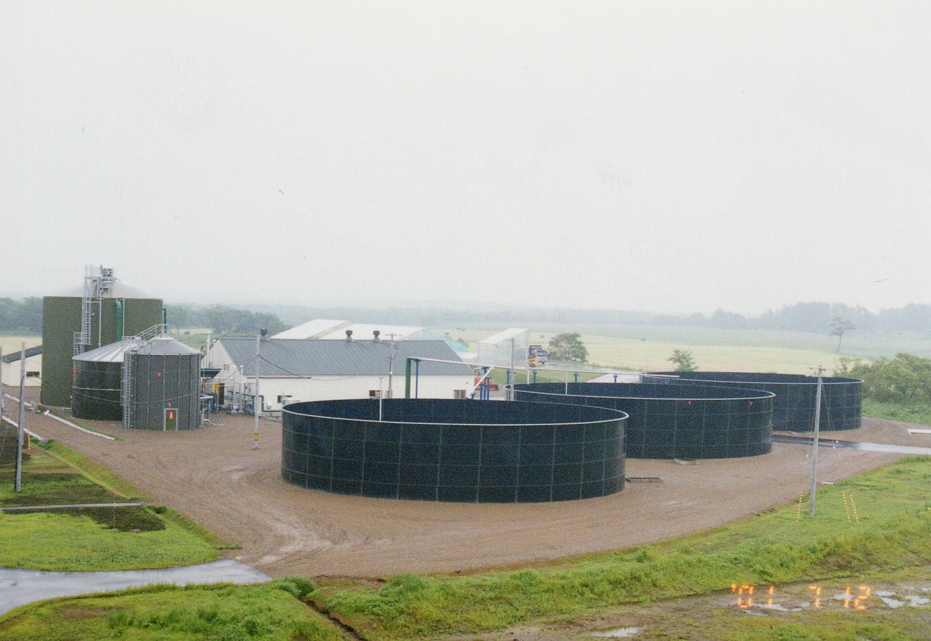 External view of the biogas plant |
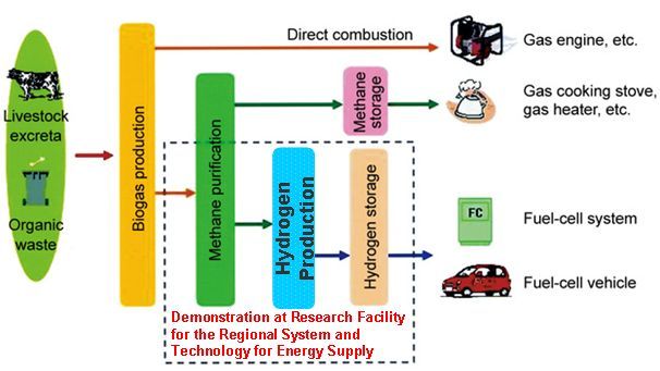
Biogas plants efficiently produce biogas from materials that include livestock
excreta and other organic wastes. Using such wastes has benefits that go
beyond effectiveness in measures against global warming; it also helps
reduce garbage through recycling. Among the most common uses of biogas
are power generation with gas-engines that directly combust it as well
as utilization of heat generated by gas boilers. However, if the methane
that is included in biogas is purified, it can be used in household water
heaters, gas cooking stoves, heating equipment, and other devices. Moreover,
refined purified methane can be used to produce hydrogen, making it usable
for power and heat energy through fuel-cell systems and in fuel-cell vehicles.
In 2003, the Civil Engineering Research Institute for Cold Region(CERI)
installed a demonstration plant for producing and storing hydrogen (Research
Facility for the Regional System and Technology for Energy Supply) in Betsukai
Town of eastern Hokkaido. It also conducted experimental studies on technologies
for producing hydrogen from biogas as well as technologies for storing
and supplying hydrogen using organic hydride. The following provides a
brief introduction to these technologies.
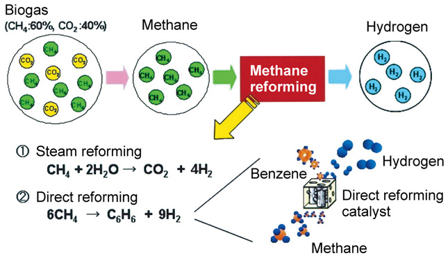
Hydrogen production technologies
The demonstration plant produces hydrogen from methane using two processes: the steam reforming method and the direct reforming method. The former is a practical method that produces hydrogen from methane and other hydrocarbons. The latter uses a new technology that is still under development to produce hydrogen as well as benzene (C6H6) and other aromatic conpounds as byproducts. Benzene is a useful substance that has become a basic ingredient of chemical products, and is expected to have effective uses together with hydrogen.
Hydrogen storage technologies
While methods for storing hydrogen include storage in compression cylinders, as liquid hydrogen, in metal hydrides, and in organic hydrides, this study demonstrated technologies for storing and regenerating hydrogen using organic hydrides. Organic hydride represents a method for storing hydrogen in a material state in which hydrogen has been added to an aromatic compound. Aromatic compounds thought usable as storage material include toluene, benzene, and naphthalene. Organic hydride has advantages that include being easy to handle, as it is in liquid form under normal temperatures and pressures, and ability to be used at existing petroleum infrastructure, such as gas stations.
(Contact: Rural Resoueces Conservation Research Team, CERI)
Cool Pavement: Pavement that Controls Rises in Road Surface Temperature
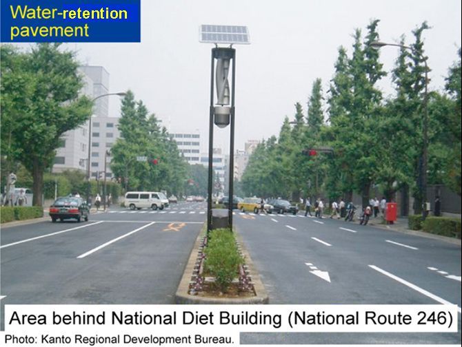 Example of construction with water-retention pavement |
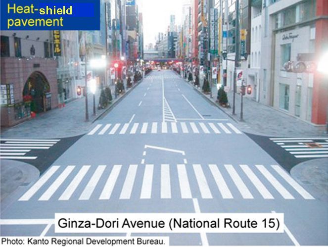 Example of construction with heat-sheild pavement |
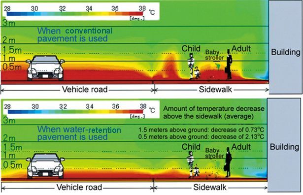 Example of simulation results |
During sunny summer days, the surface temperature of pavement can reach
as high as 60 degrees Celsius This heating is said to be a factor behind
the “heat island” phenomenon that occurs in urban areas. Thus, pavements that reduces surface
temperature-such as water-retention pavement and heat-shield pavement-are
receiving increasing attention. The Pavement Research Team is currently
involved in studies on the effectiveness of these technologies and methods
for evaluating them.
Water-retention pavement has water-retentive materials mixed into it. These
materials allow the pavement to reduce road-surface temperature through
the evapotranspiration of moisture. Heat-shield pavement is made by applying
a special coating that reflects near-infrared rays to the pavement surface.
In recent years, the national government, local governments, and others
have been using these technologies in an increasing number of construction
projects.
Both water-retention pavement and heat-shield pavement are effective in
reducing summer daytime road-surface temperature by more than 10 degrees
Celsius compared to conventional pavement. Moreover, it has been confirmed
from both actual measurements and simulations that they reduce the temperature
1.5m above the ground by approximately 1 degree Celsius. Given on these
findings, it is thought that the pavements have even greater effects for
roadside environments, and particularly for pedestrians in environments
near the road surface, such as children and babies in strollers.
In addition to water-retention pavement and heat-shield pavement, it has been confirmed that pavements that utilize natural materials, such as soil pavement, can also function to reduce road-surface temperature. While these technologies are already being used as scenic pavements in parks, the Pavement Research Team is moving forward with research toward making them suitable for sidewalks.
(Contact: Pavement Research Team)
“Scenic Northern Roads” that Present Hokkaido´s Roadside Environments: Study toward Creating Beautiful, Comfortable Roadside Environments in Hokkaido
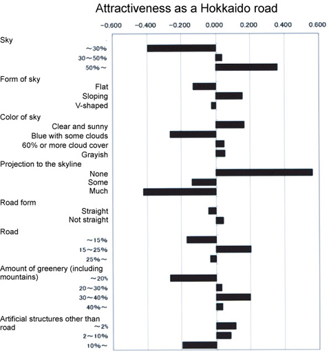 Analysis of factors that influence the attractiveness of Hokkaido´s roads |
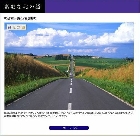 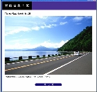 Left: Municipal Route 11 West, Kamifurano Town Right: National Route 453, Lake Shikotsu |
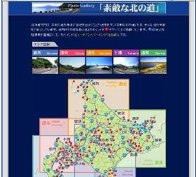 Front page of the Suteki-na Kita-no-Michi website (http://northern-road.jp/scenic/) |
The CERI´s Scenic Landscape Research Unit is studying the creation of beautiful
roadside landscapes and comfortable touring environments as well as information
services that support driving-oriented tourism. Through the “Study toward Creating Beautiful, Comfortable Roadside Environments in Hokkaido,” the unit is moving forward with concrete studies that are tied to improvement
of roadside scenery, and examining factors that influence the attractiveness
of Hokkaido´s roads.
In the figures at right, when the area of sky in the scenic photographs of Hokkaido meets or exceeds 50%, the horizontal axis becomes positive. This means that when a scenic photograph has a sky area of 50% or more, this sky area has a high degree of influence on the attractiveness of the particular Hokkaido road.
Much of the photographic data obtained through research studies conducted
thus far are scenic photographs of Hokkaido´s roads, including those that
feature Hokkaido´s grand natural landscapes. These photographs are being
put to secondary use through display on the “Suteki-na Kita-no-Michi” (scenic northern roads) website. In recent years, driving-oriented tourism has been increasing due to a shift toward individual travel (as opposed to group tours) and increased use of rental cars. In line with this trend, the website has been receiving an increasing number of hits, totaling more than 34,000 (or more than 90 hits a day) during FY2007. Data on scenic northern roads that are stored in this website are also linked to the “distance and time search” function of the “Northern Road Navi” website (http://northern-road.jp/navi/time), where they are presented
as information on recommended driving options in the results of distance
and time searches.
Today, 138 locations throughout Hokkaido-including such popular Hokkaido
tourist locations as Sapporo, Furano, and Shiretoko-are listed in the website.
Everyone planning a driving tour of Hokkaido is encouraged to use it.
(Contact: Scenic Landscape Research Unit, CERI)