
Levee Breach Experiment by Overflow with Full-scale Levee Model
Tokachi River Chiyoda Experimental Channel
 Tokachi River Chiyoda Experimental Channel 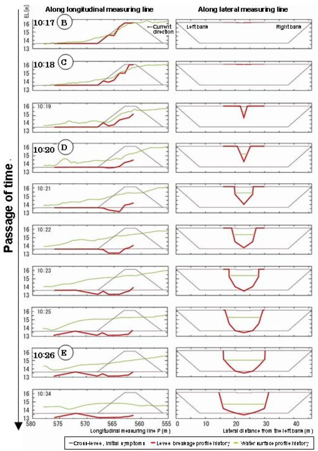 (Right) Break develops first vertically and then horizontally. (Left) Levee broken by overtopping. |
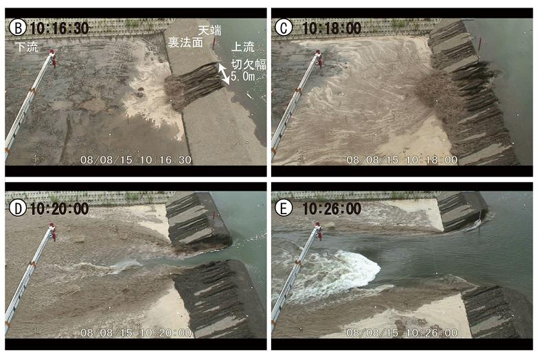 Levee being breached by overflow |
Recent years have seen many storm disasters due to typhoons and concentrated
rainfall, which in some cases are accompanied by levee breaches. Damage
caused by levee breaches in particular is enormous, and more than 80 percent
of levee breaks are estimated to be because of overflowing levees.
The current research on levee breaching by overflow has yet to explain the mechanism of full-scale 3D levee breach with the river flow taken into account. Clarifying this is expected to allow improvement of crisis management techniques for levee restoration after breaking, improvement in hazard map accuracy, and other results that can then be fed back to the government. This would also be very important for the development of future research on levee breach by overflow.
The Civil Engineering Research Institute for Cold Region (CERI) and the
Hokkaido Development Bureau, MLIT are currently using the Tokachi Chiyoda
Experimental Channel as a full-scale experimental channel to conduct various
tests. Tests on the subject of levee breaks have taken place since FY2008.
Techniques to verify the functionality of measuring instruments and measuring
methods were established in FY2008. In addition, a cross-levee was built
in the Chiyoda Experimental Channel to clarify the breaching process of
lateral over flow across levee by overflow (how a levee is destroyed by
overflow) , and we carried out a experiment of levee breach in 2D by a
front overflow.
The test results have revealed the following.
(1) We have found out that the breaching process of lateral over flow across levee by overflow is not caused by the effect of water flow, but rather the collapse develops first in the vertical direction, which renders the surrounding earth and sand unstable, thereby accelerating widening. While this was only an assumption based on the results of indoor tests in past studies, the present test confirmed the phenomenon with a full-scale model.
(2) The geometric characteristics of the pool dug by the water flow formed in the Chiyoda Experimental Channel were confined in the range of past indoor tests and cases of disaster damage. This means that the findings from the levee breach experiment by overflow in the Chiyoda Experimental Channel can be applied to other studies going forward.
(3) A method has been established in which a sensor is used to measure the acceleration to determine the breaching process in which the phenomenon is high speed and invisible without the need to stop running the water even with a full-scale model.
From FY2009 onwards, experiment of full-scale levee breach in 3D by overflow will start using the Chiyoda Experimental Channel to clarify the mechanism in greater detail.
(Contact: River Engineering Research Team, CERI)
Fish in Rice Paddies and Rivers: Ecological network
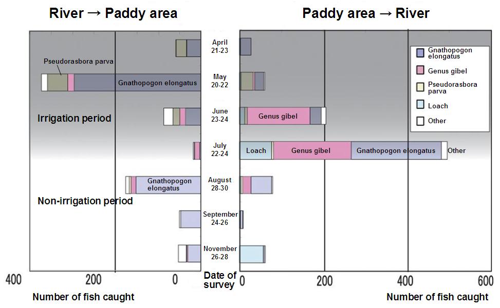 Figure 1 Number of fish moving between rice paddies and the river |
 Photo 1 Catfish spawning in a rice paddy 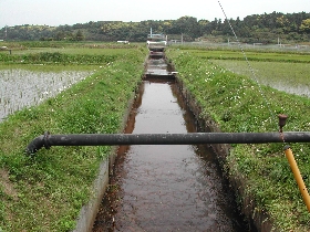 Photo 2 Example of rice paddy/channel near the rice paddy being more difficult for fish to enter |
Right after the holidays in May, the rice field seen from the window of
the lab are filled with water and look like a mirror. In the rice planting
season, various fish including loach, carp, gibel, and catfish can be found
in paddies and irrigation channels. Since some rice field become completely
dry in the winter, where do these fish come from?
Figure 1 shows the number of fish caught in a net set between a river and the rice paddies in order to find out how fish come and go between the rice paddies and the river. Around May, rice planting season was over at the observed rice fields , carp, gibel, and many other fish were found going from the river to the paddy area. In June and July, these kinds of fish go down from the paddy area to the river, the opposite direction of that in May. In fact, many of the fish heading toward the paddy area are adult fish with roe that spawn in irrigation channels and paddies. Some large catfish and carp were found spawning in rice paddies immediately after rice planting (Photo 1). In June and July, fry that have grown in the paddies and irrigation channels move toward the river.
Recently, however, some paddy fields are found without these fish. As a result of the improvement of rice paddies to increase the size of each paddy, reduce the burden of rice farming, and make water management simpler, differences in level were generated between the paddies and channels and in the middle of channels, making it difficult for fish to enter the rice paddies and the surrounding channels around (Photo 2). Additionally, in the paddy area shown in Figure 1, the pump that supplies water to the rice paddies is stopped at the end of July as part of the preparation for harvesting and the paddies and irrigation channels dry up. In the survey at the end of July, many fry and loach were found going down from the paddy area to the river and not a few fry were left behind in the middle of the irrigation channels as well.
In this way, rice paddies and irrigation channels have significantly changed for fish as compared with the past, but some fish are tough enough to take advantage of this change. For example, in an irrigation channel that is not connected to any river and loses water in winter, fish that used small pools to overwinter were found to have explosively multiplied in the spring. The fact that enemies cannot intrude evidently benefits those fish. In another irrigation channel, the differences in level were found to have prevented invasion of nonnative species from the river.
While rice paddies and irrigation channels are human-managed bodies of water, fish, amphibians, insects, and other creatures make use of them in various ways. Creatures nurtured in these areas are associated with other creatures in wider areas through rivers. To preserve the environment of rice paddies, information on human activities in paddy areas and creatures in rivers in the surrounding areas, and various factors - not the least of which is the ecology of the fish in the area - must be taken into consideration.
(Contact: River Restoration Research Team)
New Emergency Monitoring Technique for Natural Dams:
Aerially placeable floating water gauge (APF gauge)
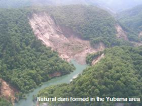 Aerial photo of a natural dam 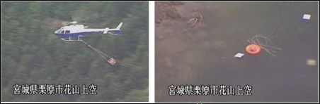 Air transportation and installation of APF gauge |
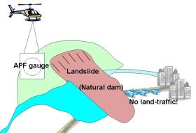 One of the cases in which the APF gauge should be utilized 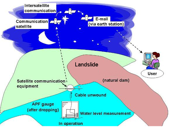 Data acquisition via satellite which is capable of acquiring data even under a situation of damage of information infrastructure |
The Iwate-Miyagi Nairiku Earthquake in 2008, which occurred on Jun. 14th, caused many large-scale landslides near Mt. Kurikoma, generating many natural dams that posed threat to downstream areas. Natural dams are formed by sediment due to landslides interrupting the flow of river water. Unlike artificial dams, water overflowing such dams erodes the sediment that interrupt the water, which may cause a large flash flood to hit downstream areas and consequently posed extreme danger. Accordingly, if any natural dam is found to have been formed by an earthquake or other cause, the water level rise must be immediately monitored carefully.
After any earthquake large enough to form a natural dam, however, traffic and communication networks are often interrupted and rushing to the site to measure the water level is often difficult. For this reason, there has long been a desire for the development of a technology to allow for water levels to be monitored after the earthquake has occurred. In response, PWRI's Volcano and Debris Flow Research Team has developed and constructed the aerially placeable floating water gauge (APF gauge) capable of water level measurement and data transmission simply by being placed from a helicopter as an emergency monitoring technique for use after the formation of a natural dam.
The APF gauge the team has developed is composed of a buoy integrating communication equipment, a cage-weight equipped with a water level sensor, and a cable connecting the two. Before use, the buoy and cable are stored in the cage-weight to allow air transportation. Once it has been dropped into the water, the cage-weight and water level sensor sink to the bottom and the buoy is separated from the cage-weight due to its buoyancy causing it float to the water surface. The key is that the cable is subsequently unwound by length according to the water depth to be immediately ready the buoy to measure the water level and send data. The satellite communication equipment then sends the measured water level data by e-mail to disaster management staff via the communication satellite, which allows the water level information to be acquired from a remote location. All that is necessary to do on site is to place the gauge from a helicopter.
His APF gauge was put for practical use for one of the natural dams (dam
height: approximately 40m) formed by the Iwate-Miyagi Inland Earthquake.
The water level data was sent in real time to the Tohoku Regional Bureau,
who was implementing emergency disaster prevention works, and used as basic
data for disaster management. This measuring equipment has been registered
as a utility model (No. 3149794).
(Contact: Volcano and Debris Flow Research Team)