
GUIDELINE TO GEOLOGICAL/GROUND RISK MANAGEMENT IN PUBLIC WORKS PROJECTS

information through linkages
1. Introduction
The distributions of geology and ground are complex and not necessarily uniform and it is difficult to clarify their distributions in advance, so they are characterized by great uncertainty, which is uncertainty which severely impacts efficiency and safety of projects by, for example, delaying work, increasing project costs and causing accidents. MLIT and PWRI published the Guideline to Geological/Ground Risk Management in Public Works Projects in March 2020 in order to that public works projects will be safely and efficiently conducted considering the impact of uncertainty regarding geology and ground (= Geological/Ground Risk).
2. Geological/Ground Risk Management System
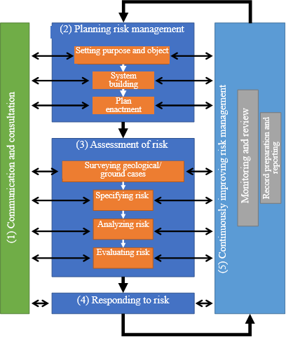
Geological/ground risk management done by systematically and methodically dealing with geological/ground risk formerly done unconsciously will be introduced and operated while utilizing certain efforts and systems as in the past. When it is introduced, a system will be constructed by concerned parties who possess specialized knowledge necessary to conduct technical studies. At this time, information which other concerned parties require will be shared and transmitted as shown in Figure 1 to forge strong mutual relationships, a process which is counted on to obtain results superior to those achieved when all parties play their separate roles.
3. Method of performing geological/ground risk management
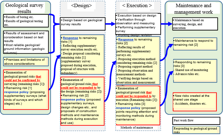
Geological/ground risk management is done by establishing project implementation strategies considering which stages and during which processes it is beneficial to deal with risk. As shown in Figure 2, while working through the process, "[2] Planning risk management", "[3] Assessment of risk", and "[4] Responding to risk", information about risks which have been overcome and remaining risks is handed on to the next stage (Fig. 3). It is also important that, beginning at an early stage of the project, the process and system are reviewed according to risks which are transformed as the project advances.
4. Conclusion
The PWRI plans to continue research and extension activities in cooperation with the MLITT and other concerned academic organizations in order to expand the application of and support the operation of geological/ground risk management
Note See the following web page for details concerning the guideline.
(https://www.pwri.go.jp/jpn/research/saisentan/tishitsu-jiban/iinkai-guide2020.html)(Contact: Geology Research Team)
Development of slit-type fishways which are now in demand
--Overwhelming "low cost" fishways--
1. What fishways are now in demand?
Recent years have seen a growing need for fishways which in addition to meeting the demand for the longitudinal continuity of rivers, also satisfy a demand for lateral continuity linking main river courses, tributaries, paddy fields, and flood plains, both necessary to preserve biodiversity. But in fact, economic circumstances and other factors faced by river managers have resulted in them neglecting to provide many lateral river structures (below, "structures"). Studies of the installation of fishways or the removal of other structures have been carried out in order to allow fish and other aquatic life (below, "fish etc.") to travel upstream in rivers, but in all cases, the cost of taking any measures to achieve this goal rises sharply as the height of the structure increases. A measure executed by performing simple excavation of a structure itself is considered to be an approach that fully guarantees structural safety as it allows fish etc. to travel upstream more efficiently, at lower cost, and with less maintenance. So, this study developed a low cost slit-type fishway by proposing forming slits in existing structures (Photo 1).
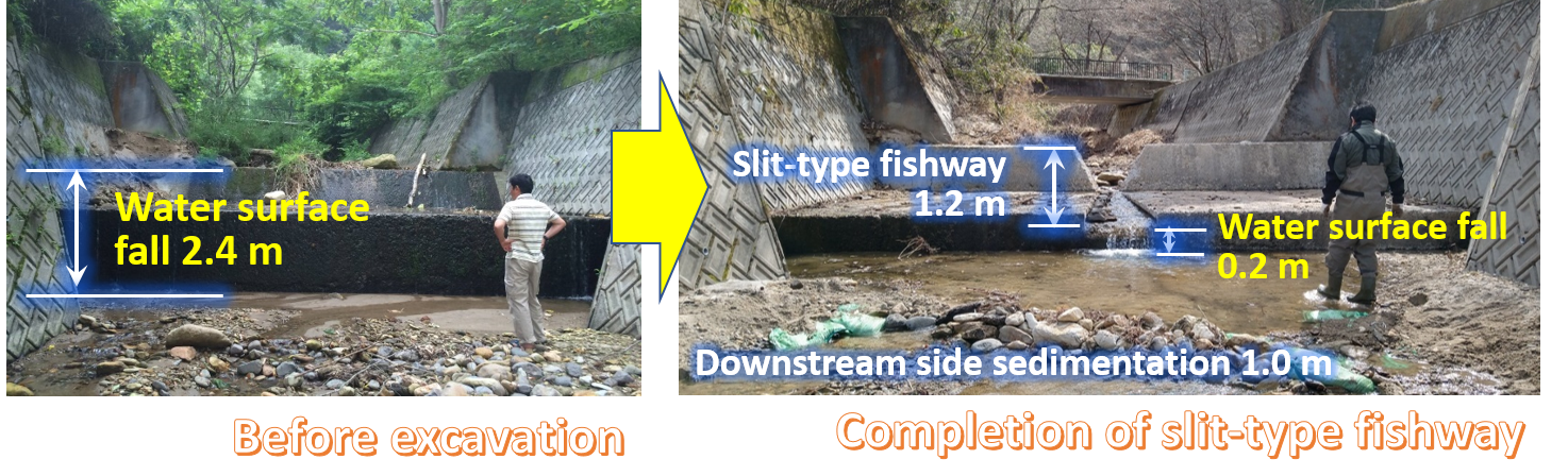
of the slit-type fishway (right) The 2.4 m water surface fall is reduced to 0.2 m.
(Slit-type fishway effects: 1.2 m, downstream side sedimentation effects: 1.0 m)
2. Installing overwhelmingly low cost slit-type fishways
It is possible to install a slit-type fishway by fully guaranteeing the safety of the structure itself and obtaining the permission of its manager. A slit-type fishway can be installed for a cost far below that of installing a normal fishway or removing a structure because the major work process is excavating the existing structure. A study of upstream travel of fish etc. with a structure that is 3 m in height for example has shown that installing this as a normal fishway would cost between 20 million and 30 million yen and take about half a year, but installing it as a slit-type fishway would cost only a few hundred thousand yen and could be done in between 1 and 3 days, permitting a great reduction of cost and shortening of the work period.
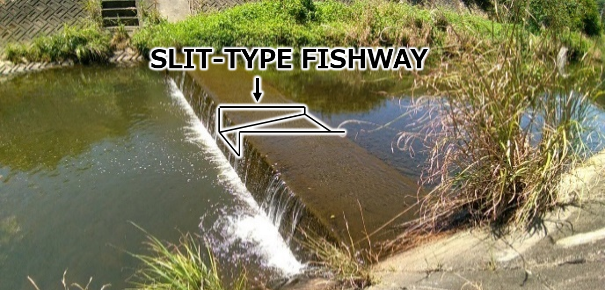
Other characteristics of the method include its high degree of suitability for environmental farming that brings fish back to the fields in addition to its applicability to projects on rivers both inside and outside of Japan. Separate studies are needed in cases of structures for which water rights have been enacted, but if it can obtain a water level on its downstream side similar to the case shown in Photo 2 and is no higher than about 3 m, installing a slit-type fishway can provide adequate upstream travel effects.
3. Allowing all aquatic life to travel upstream
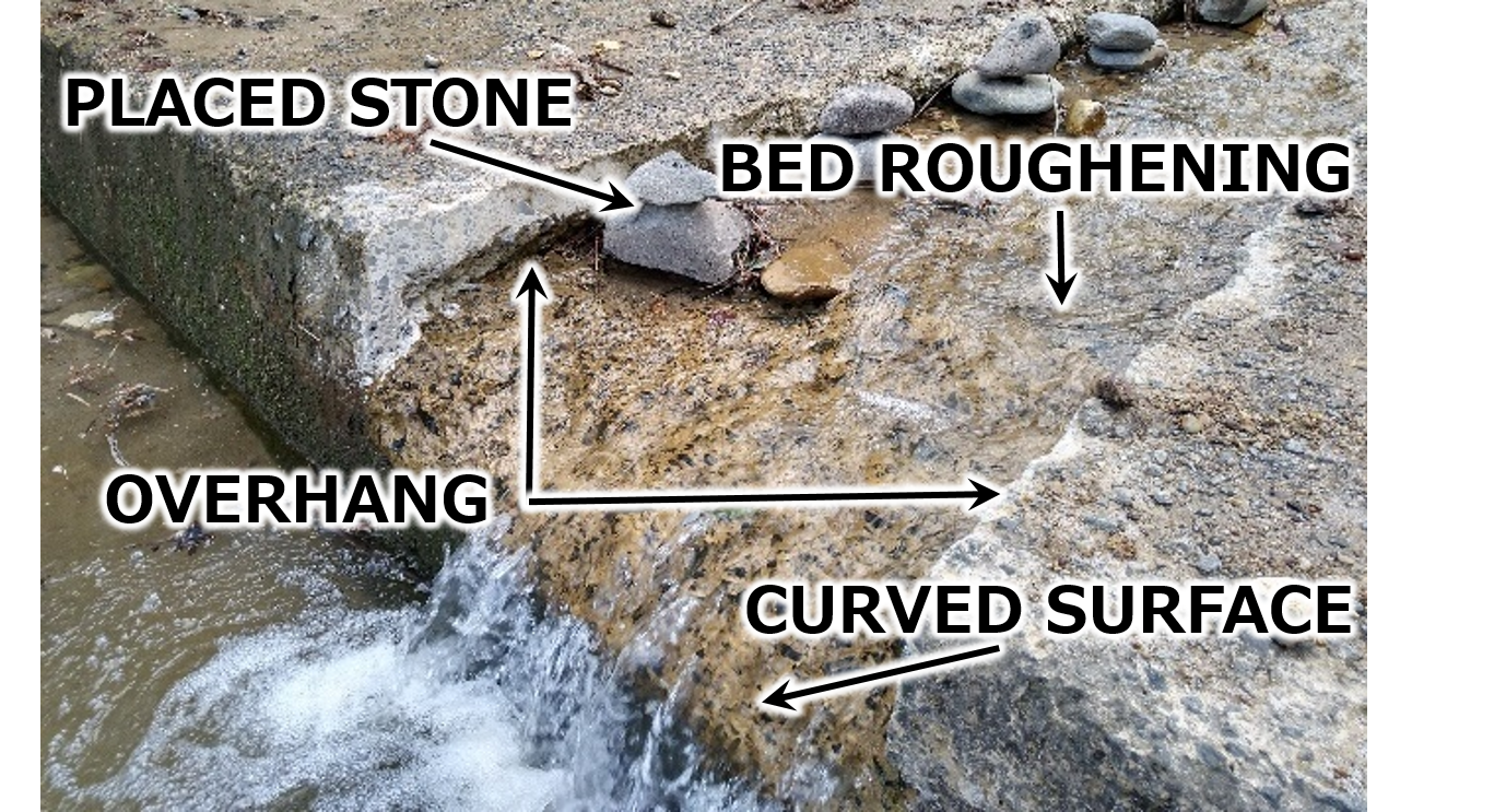
A slit-type fishway has, in order to allow upstream travel by a diverse range of aquatic life including small fish, shell fish etc., been constructed by as its basic details, [1] forming an overhang by cutting into the walls of the channel in order to create shaded areas on the fishway, [2] placing stones in order to create a variety of flow speeds in the fishway, [3] increasing the roughness of the bottom surface by coarsening it in order to lower the flow speed in the fishway, and by [4] forming a curved surface at its mouth so that fish etc. can effortlessly enter the fishway by keeping air out from under the water vein (Photo 3). Clarifying the upstream travel effects has shown that the simultaneous use of above four techniques simultaneously to design a single fishway is almost completely unprecedented.
4. Preserving biodiversity
Cash-strapped local governments and citizens groups can also install slit-type fishways to contribute to the preservation of biodiversity at extremely reduced cost. It can be predicted that nature conservation activities and enlightenment activities will be undertaken through cooperation between private citizens and CSR activities of corporations and slit-type fishway technology will also contribute to such activities. The first slit-type fishway has been installed on a weir in Sendai City and has begun to allow fish etc. to travel upstream. At this time, many neo-natural improvement workshops and a survey of fish etc. inhabiting the water upstream from the slit-type fishway are being conducted by administrative bodies, private organizations and academic groups.
※Please view an explanatory video and read a paper for details about excavation methods and how to ensure safety.
https://www.pwri.go.jp/team/kyousei/jpn/events/m5_r2_01.htm(Contact: Aqua Restoration Research Center)
The influence of the elements in the photo samples on the results of an evaluation of landscapes and other spaces using photos
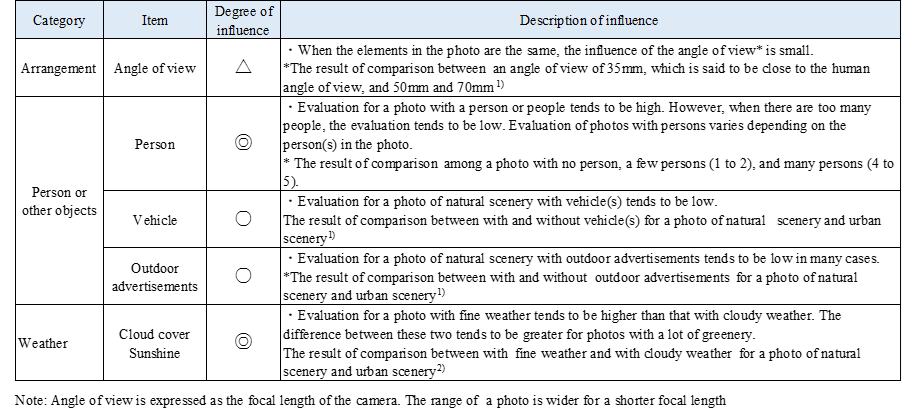
In implementing public projects, we sometimes evaluate landscapes and other spaces by using evaluation samples. The samples are often photos or photomontages (processed images using actual photos) and used for comparing plans, designs, or before and after construction. In using these evaluation samples, the impression of the project changes depending on the elements in the sample photos or photomontages, including persons, vehicles, weather, or the arrangement of the elements in the sample. Therefore, it is necessary to create sample photos for impression evaluation based on understanding the influence of elements used in the photos.
There have not been sufficient studies investigating the influence of elements in sample photos based on impression evaluation experiments. The Scenic Landscape Research Team conducted impression evaluation experiments using evaluation sample photos, in which the elements were changed, and analyzed the influence of the elements on the evaluation results. The influence of elements on the evaluation results varies depending on the subject landscape or space for evaluation. The results we obtained in one of our experiments are shown in Table 1. The examples of evaluation samples for which the weather and persons in the sample, which we thought to have considerable influence on evaluation results, influenced the evaluation (Fig. 1). By clarifying this point, we can improve landscape and space evaluations for public project planning. We are planning to publish the results of our research as a landscape evaluation point book.
Table 1 Major influence on the evaluation result [Legend: Degree of influence] ◎:High ○: Moderate △:Low
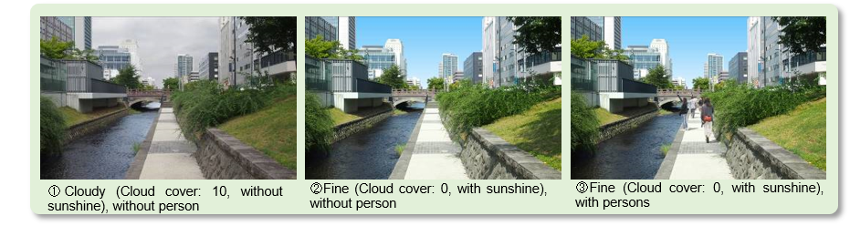
The test subjects are asked "Do your feel the space with a foot path by the river attractive?" The test subjects evaluated the photo using a 6-point scale. 2)The average evaluations for the photos were ①<②<③.Significant differences in the average evaluation values were found between ① and ② and between ② and ③.
[References]
1)Hitomi Oguri, Keisuke Iwata, and Yasuaki Matsuda: The Influence of Sample Creation Methods on Evaluation
Results -- Toward Packaging Landscape Evaluation Techniques using the Semantic Differential Method, Papers
of Research Meeting on Civil Engineering Planning, Vol. 52, 2015.
2)Keiji Tamiya, Satoshi Kasama, and Yasuaki Matsuda: The Influence of Clouds and Sunshine in Photos on
Landscape Evaluation Results -- Toward Proposal for Landscape Prediction and Evaluation Techniques,
The 64th Annual Research Conference of Hokkaido Development Technologies, 2020. (Submitted)
(Contact: Scenic Landscape Research Team, CERI)