Global Center of Excellence for Water Hazard and Risk Management
ICHARM The International Centre for Water Hazard

"Flood Hazard Mapping" Training Course & Follow-up Seminar
What is a "Flood Hazard Map"?
A "Flood Hazard Map" herein referred to is a map that graphically provides information on inundation (predicted inundation areas, inundation depth, etc.), as well as on evacuation (location of evacuation refuges, evacuation routes, dangerous spots on evacuation routes, etc.) in an easy-to-understand format. The goal is to quickly evacuate local residents in a safe and proper manner in the event of floods. The map is produced and publicized through a joint effort by those in charge of disaster prevention and those in charge of rivers and hydrology in the respective local municipalities. (By "Flood Hazard Map Manual for Technology Transfer", Ministry of Land, Infrastructure and Transport, Infrastructure Development Institute-Japan)
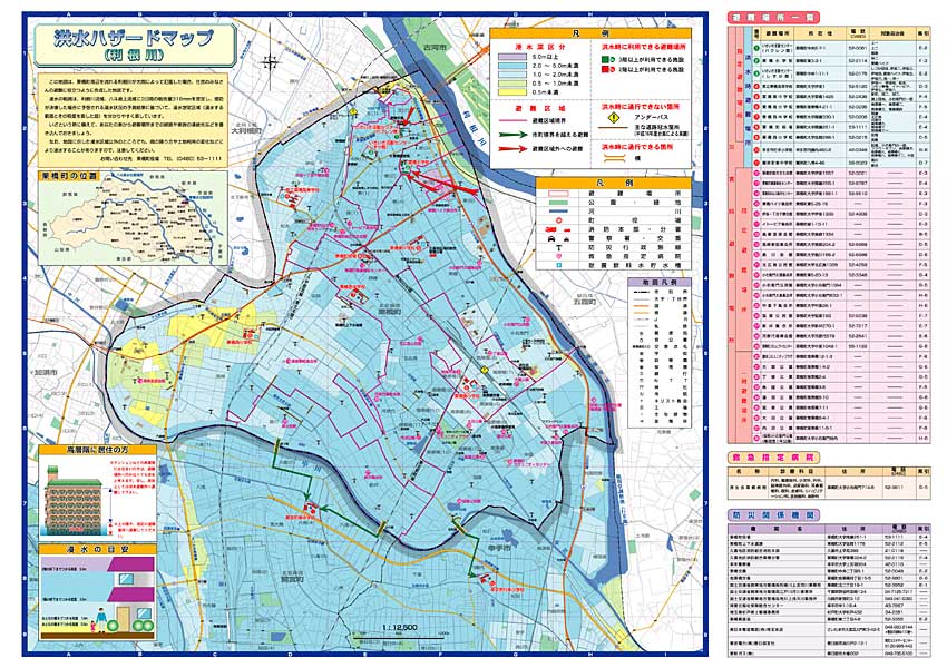
Example of "Flood Hazard Map" in Kurihashi Town, Saitama Prefecture
Click above photo!
[UP]
- ICHARM training policy & activities
- Doctoral Course "Disaster Management"
- Master's Course "Water-Related Risk Management Course of Disaster Management Policy Program"
- "Flood Hazard Mapping" Training Course & Follow-up Seminar
- Preface
- What is a "Flood Hazard Map"?
- Reports
- Follow-up Seminar
- "JICA Training Program: Capacity Development for Flood Risk Management with IFAS" Training Course
- "Comprehensive Tsunami Disaster Prevention" Training Course
- "Capacity Development for Adaptation to Climate Change –Climate Modeling and Analysis" Training Course